Castle Crag, Shoulthwaite

Overview
Height: 1,325 Feet - 404 Metres
Grid Ref: NY 299 188
Area: Central
Group: W/DER
Ordnance Survey: OL4
 

Map and Photo Gallery


Walks including Castle Crag, Shoulthwaite are:-

Raven Crag & Castlerigg Stone Circle


7th September 2014
ASCENT: 2,215 Feet – 675 Metres
MILES: 9.7
WAINWRIGHTS: 2,  Raven Crag – High Rigg
ROUTE: Castlerigg Stone Circle – Castle Lane – A591 – Nest Brow – Brackenrigg – Shoulthwaite – Shoulthwaite Gill – Castle Crag (fort) – Raven Crag – Thirlmere Dam – A591 – St Johns Beck – High Rigg – St Johns-in-the-Vale Church – Low Rigg – Tewit Tarn – Naddle Bridge – Goosewell Farm – Castlerigg Stone Circle
 

Raven Crag from Castlerigg Stone Circle

View this walk

9th June 2013
ASCENT: 2,215 Feet, 675 Metres
MILES: 9.6
WAINWRIGHTS: 1, Raven Crag
ROUTE: Castlerigg Stone Circle – Castle Lane – A591 – Nest Brow – Brackenrigg – Shoulthwaite Gill – Castle Crag (fort) – Sippling Crag (The Benn) – Raven Crag – Thirlmere Dam – A591 – St Johns Beck – Sosgill – Rake How – St Johns-in-the Vale Church – Low Rigg – Tewit Tarn – Naddle Bridge – Goosewell Farm – Castlerigg Stone Circle
 

Raven Crag & Armboth Fell

View this walk

13th October 2012
ASCENT: 1,800 Feet, 548 Metres
MILES: 7.5
WAINWRIGHTS:

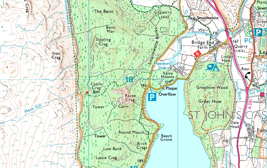
2, Armboth Fell & Raven Crag

ROUTE:

Armboth – Lake Path – Forest Track to Raven Crag – Sippling Crag (The Benn) – Raven Crag- Castle Crag (Fort) Forest Track – Armboth Fell – Fisher Gill – Armboth


Back to top