|
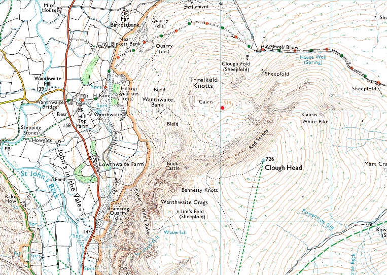
Threlkeld Knotts |
 |
 |
Overview |
 |
|
| Height: |
1686 Feet - 514 Metres |
| Grid Ref: |
NY 330 230 |
| Area: |
Eastern |
| Group: |
C/DOD |
| Ordnance Survey: |
OL5 |
|
| |
|
Map and Photo Gallery |
|
|
|
| |
|
Walks including Threlkeld Knotts are:- |
|
|
The Dodds from Sticks Pass |
|
|
 |
|
22nd February 2025 |
| ASCENT: |
2,870 Feet - 874 Metres |
| MILES: |
8 |
| WAINWRIGHTS: |
4, Stybarrow Dodd - Watson's Dodd - Great Dodd - Clough Head |
| ROUTE: |
Stanah - Sticks Pass - Top of Sticks Pass - Stybarrow Dodd - Watson's Dodd - Great Dodd - Calfhow Pike - Clough Head - Red Screes - Threlkeld Knotts - Old Coach Road - Hill Top Farm - Wanthwaite |
|
| |
|
Walking the Birketts, Over Clough Head to Great Dodd |
|
|
|
|
19th June 2021 |
| ASCENT: |
2,959 Feet - 902 Metres |
| MILES: |
8 |
| BIRKETTS: |
6, Threlkeld Knotts - Clough Head - Calfhow Pike - Little Dodd - Great Dodd - Randerside |
| ROUTE: |
Wanthwaite - Old Coach Road - Wanthwaite Bank - Threlkeld Knotts - Clough Head - Calfhow Pike - Little Dodd - Great Dodd - Randerside - Matterdale Common - Wolf Crags - Old Coach Road |
|
| |
|
The Dodds and Sticks Pass from Wanthwaite |
|
|
|
|
4th February 2018 |
| ASCENT: |
3,846 Feet - 1,173 Metres |
| MILES: |
11.5 |
| WAINWRIGHTS: |
4, Clough Head - Great Dodd - Watson's Dodd - Stybarrow Dodd |
| ROUTE: |
Wanthwaite - Old Coach Road - Threlkeld Knotts - Clough Head - Great Dodd - Watson's Dodd - Stybarrow Dodd - Sticks Pass - Stanah - Low Bridge End Farm - St-John's-in-the-Vale - Sosgill Bridge - Wanthwaite Bridge - Wanthwaite |
|
| |
| Back to top |
 |
|