|
Parking Information for - Car Park, Cow Bridge, near Hartsop |
 |
 |
Parking Details and Map |
 |
|
| Nearest Post Code: |
CA11 0NZ |
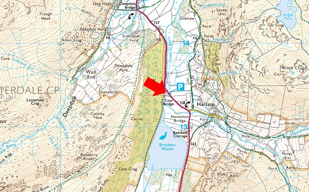
| Grid Reference: |
NY 402 813 |
| Notes: |
Found between Hartsop and Patterdale Cow Bridge car park is split into two by Goldrill Beck and is owned by the National Trust. The car park gives easy accses to Brothers Water the hamlet and Hartsop and of course a varity of eastern fells and valleys. Parking is free for National Trust Members but charges apply for non members. |
|
| |
|
Walks starting from this parking place |
|
|
|
Kirkstone Pass to Hartsop via High Street |
|
|
 |
|
2nd November 2024 |
| ASCENT: |
2,238 Feet - 682 Metres |
| MILES: |
7.7 |
| WAINWRIGHTS: |
6, Caudale Moor - Thornthwaite Crag - High Street - The Knott |
| ROUTE: |
Top of Kirkstone Pass - St Raven's Edge - Caudale Moor - Stony Cove Pike - Thresthwaite Mouth - Thornthwaite Crag - High Street - Straights of Riggindale - The Knott - Hayeswater Gill - Hartsop - Cow Bridge |
|
| |
|
Dove Crag via the Dovedale Valley |
|
|
|
|
24th September 2022 |
| ASCENT: |
2,583 Feet - 787 Metres |
| MILES: |
7 |
| WAINWRIGHTS: |
3, Dove Crag - Little Hart Crag - High Hartsop Dodd |
| ROUTE: |
Cow Bridge - Brothers Water - Hartsop Hall - Dovedale - Houndshope Cove - Dove Crag - High Bakestones - Bakestones Moss - Little Hart Crag - High Hartsop Dodd - Hartsop Hall - Brothers Water |
|
| |
|
Dove Crag via the Dovedale Valley |
|
|
|
|
2nd October 2019 |
| ASCENT: |
2,583 Feet - 787 Metres |
| MILES: |
7 |
| WAINWRIGHTS: |
3, Dove Crag - Little Hart Crag - High Hartsop Dodd |
| ROUTE: |
Cow Bridge - Brothers Water - Hartsop Hall - Dovedale - Houndshope Cove - Dove Crag - High Bakestones - Bakestones Moss - Little Hart Crag - High Hartsop Dodd - Hartsop Hall - Brothers Water |
|
| |
|
Fairfield via The Step |
|
|
|
|
2nd September 2019 |
| ASCENT: |
2,872 Feet - 875 Metres |
| MILES: |
7 |
| WAINWRIGHTS: |
2, Fairfield - St Sunday Crag |
| ROUTE: |
Deepdale Bridge – Wall End – Deepdale – Mossydale – Link Cove – The Step – Link Hause - Fairfield – Cofa Pike – St Sunday Crag – Gavel Pike - Lords Seat - Wall End - Deepdale Bridge |
|
| |
|
Dove Crag via the Dovedale Valley |
|
|
|
|
8th October 2017 |
| ASCENT: |
2,583 Feet - 787 Metres |
| MILES: |
7 |
| WAINWRIGHTS: |
3, Dove Crag - Little Hart Crag - High Hartsop Dodd |
| ROUTE: |
Cow Bridge - Brothers Water - Hartsop Hall - Dovedale - Houndshope Cove - Priest Hole - Dove Crag - Scandale Head - Bakestones Moss - Little Hart Crag - High Hartsop Dodd - Hartsop Hall - Brothers Water - Cow Bridge |
|
| |
|
Caudale Moor to Brock Crags via High Street |
|
|
|
|
1st July 2017 |
| ASCENT: |
4,374 Feet - 1,334 Metres |
| MILES: |
14 |
| WAINWRIGHTS: |
10, Caudale Moor (Stoney Cove Pike) - Thornthwaite Crag - High Street - Kidsty Pike - High Raise (Martindale) - Rampsgill Head - The Knott - Rest Dodd - Angletarn Pikes - Brock Crags |
| ROUTE: |
Cow Bridge - Brothers Water - Hartsop Hall - Sykeside - Kirkstone Pass - Caudale Beck - Caudale Quarry - Caudale Moor (Stoney Cove Pike) - Threshthwaite Mouth - Thornthwaite Crag - High Street - Straights of Riggindale - Kidsty Pike - High Raise (Martindale) - Rampsgill Head - The Knott - Rest Dodd - Satura Crag - Angle Tarn - Angletarn Pikes - Cat Crag - Brock Crags - Hartsop - Cow Bridge |
|
| |
|
A Kirkstone Skyline |
|
|
|
|
12th March 2016 |
| ASCENT: |
3,130 Feet, 954 Meters |
| MILES: |
8.3 |
| WAINWRIGHTS: |
4, Hartsop Dodd - Caudale Moor (Stonycove Pike) - Red Screes - Middle Dodd |
| ROUTE: |
Cow Bridge - Hartsop Dodd - Caudale Moor (Stony Cove Pike) - St Raven's Edge - Kirkstone Pass Inn - Red Screes - Smallthwaite Band - Middle Dodd - Hartsop Hall - Brothers Water - Cow Bridge |
|
| |
|
The Harry Griffin 2,000 footers Walk 21 -Summits from Kirkstone |
|
|
|
|
25th July 2015 |
| ASCENT: |
2'561 Feet - 781 Meters |
| MILES: |
7.5 |
| SUMMITS OVER 2,000 Ft: |
3, Little Hart Crag West Top - Little Hart Crag East Top - Red Screes |
| ROUTE: |
Cow Bridge - Brothers Water - Hartsop Hall - Caiston Glen - Top of Scandale Pass - Little Hart Crag - Scandale Tarn - Top of Scandale Pass - Red Screes - Smallthwaite Band - Middle Dodd - Hartsop Hall - Brothers Water - Cow Bridge |
|
| |
|
The Kirkstone Pass Fells |
|
|
|
|
2nd March 2014 |
| ASCENT: |
3,130 Feet, 954 Meters |
| MILES: |
8.3 |
| WAINWRIGHTS: |
4, Hartsop Dodd – Caudale Moor (Stony Cove Pike) – Red Screes – Middle Dodd |
| ROUTE: |
Cow Bridge – Hartsop – Hartsop Dodd – Caudale Moor (Stony Cove Pike) – John Bell’s Banner – St Raven’s Edge – Kirkstone Pass – Red Screes – Middle Dodd – Hartsop Hall – Brothers Water – Cow Bridge |
|
| |
|
The Kirkstone Pass Fells |
|
|
|
|
28th April 2012 |
| ASCENT: |
3,215 Feet, 980 Metres |
| MILES: |
8.8 |
| WAINWRIGHTS: |
4, Middle Dodd, Red Screes, Caudale Moor (Stony Cove Pike) & Hartsop Dodd |
| ROUTE: |
Cow Bridge – Brothers Water – Hartsop Hall – Middle Dodd – Smallthwaite Band – Red Screes – Kirkstone Pass – St Ravens Edge – John Bell’s Banner – Caudale Moor (Stony Cove Pike) – Hartsop Dodd – Hartsop – Cow Bridge |
|
| |
|
The Dovedale Horseshoe |
|
|
|
|
15th August 2010 |
| ASCENT: |
2,760 Ft 841 Mtrs |
| MILES: |
7 |
| WAINWRIGHTS: |
5, Hartsop Above How, Hart Crag, Dove Crag, Little Hart Crag High Hartsop Dodd |
| ROUTE: |
|
|
| |
|
Middle Dodd & Red Screes |
|
|
|
|
19th December 2009 |
| ASCENT: |
776Mtrs 2541Ft |
| MILES: |
xxx |
| WAINWRIGHTS: |
2 Middle Dodd, Red Screes |
| ROUTE: |
xxxx |
|
| |
|
| |
| Back to top |
 |
|