|
Walking the Birketts, Grisedale Pike by the East Ridge |
 |
 |
28th April 2019 |
 |
|
Who'd have thought that bending down to put something back into the TV cabinet would be enough to put my back out because that's what happened to me on Easter Saturday causing me to miss out on a walk where I'd planned to walk a circuit of the Shap fells starting from Wet Sleddale. After plenty of rest, ice and heat two days later I was back on my feet although still painful, I could get about alot easier. That was over a week ago and although I can still feel the twinges today I decided to take on Grisedale Pike from Braithwaite otherwise known at Grisedale Pike east ridge.
The route is pretty straight forward claiming just three summits along the way starting with the cairnless grassy top that is Kin. Continuing along the ridge it starts to gain height passing Sleet How before gaining the walks main target summit, Grisedale Pike. After time getting ones breath back Hobcarton Head falls next which is found easily by continuing in a south westerly direction as views of Hopegill Head dominate the skyline. After a short ascent the summit is gained where on a clear day views extend as beyond the Hobcarton Valley towards the Lord's Seat Fells. I descend southerly crossing an infant Pudding Beck as my view is now dominated by Grasmoor and Crag Hill (Eel Crag) both perched high above Coledale Hause. It's from Coledale Hause I continue my descent into the Coledale Valley first flanking the impressive Force Crag while the sound of Low Force falls accompanies my descent to the valley floor after which, it's a lovely two mile walk back to the car. |
|
| The Complete Lakeland Fells |
 |
| By Bill Birkett |
-The East Ridge
The long aesthetic line of its east ridge takes a high profile and is understandably the most popular way to tackle the might of Grisedale Pike. |
|
|
|
| |
|
Overview |
|
|
| Ascent: |
2,434 Feet - 742 Metres |
| Birketts: |
3, Kin - Grisedale Pike - Hobcarton Head |
| Weather: |
Varied Cloud With Some Sunny Spells, Feeling Mild. Highs of 14°C Lows of 8°C |
| Parking: |
Car Park, Whinlatter Pass, Braithwaite |
| Area - Group: |
North Western - GRI |
| Miles: |
6.8 |
| Walking With: |
On My Own |
| Ordnance Survey: |
OL4 |
| Time Taken: |
3 Hours 40 Minutes |
| Route: |
Whinlatter – Kinn – Sleet How – Grisedale Pike – Hobcarton Head – Coledale Hause – Force Crag Mine – Coledale Valley – Whinlatter |
|
| |
|
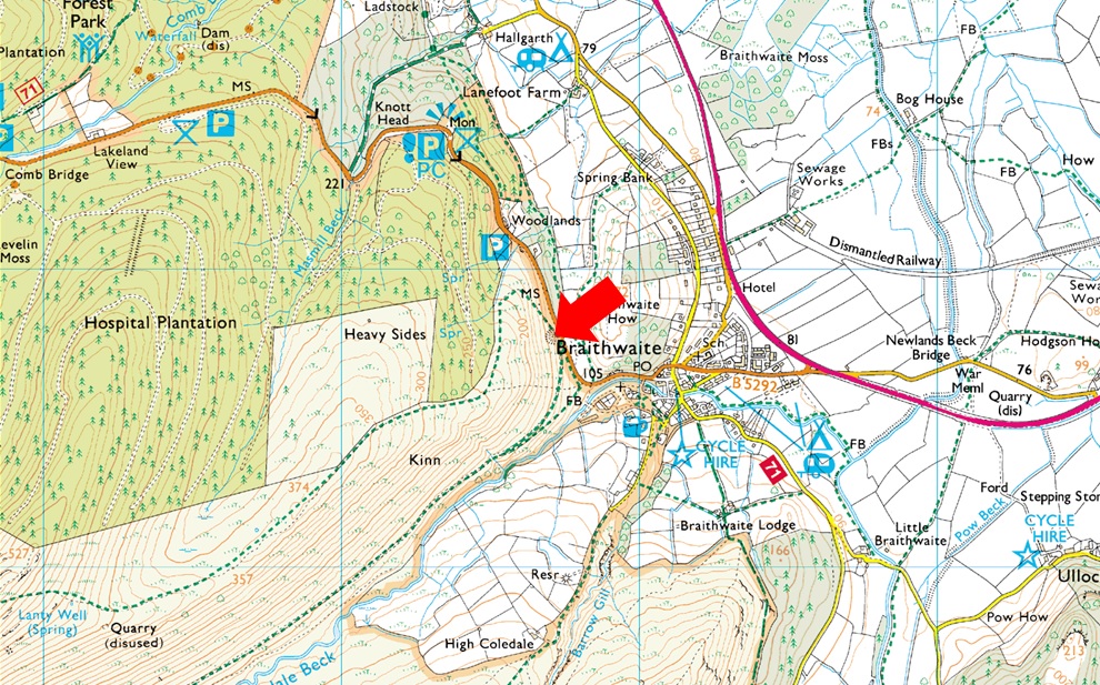
Parking Details and Map |
|
|
| Nearest Post Code: |
CA12 5TL |
| Grid Reference: |
NY 227 223 |
| Notes: |
Follow the B5292 through Braithwaite Village before joining the bottom of the Whinlatter Pass, here the road steepens after a tight right hand bend, look out for a Parking sign partially hidden by trees on the left hand side an turn left onto the car park. This car park just above Braithwaite is quite small and is very popular especially during the Summer months. The car park provides instant access to Grisedale Pike via Kinn and Force Crag mine. Parking is free. |
|
| |
|
Map and Photo Gallery |
|
|
 |
| Skiddaw, Dodd and the Ullock Pike ridge seen as I head towards Kin 08.20am 8°C |
| I've never not been able to park at the carpark just outside Braithwaite (the old sand pit) but today I grabbed the very last parking space after I arrived just gone 08:00am. I managed to shoe horn my car at the top of the car park as another car arrived whose owner was as equally as shocked as I was and reversed his car out and double-backed towards Braithwaite. It's mild but I add a soft shell anyway knowing full well within half an hour it's gonna be wrapped up back in my pack. It's been three years since I was last here and thankfully nothing has changed other than it's got busier, but so have the fells wouldn't you agree? Anyway, I left my car and began the steep slog up the steps and soon I was rising above the tree tops which revealed Skiddaw below a canopy of cloud which was actually forecast to break away through after dawn and to be honest the cloud in almost every direction is doing just that. |
 |
| Morning. |
| This cheeky chappie accompanied my ascent through the woodland skipping from branch to branch up ahead of me, he even let me take this photo. |
 |
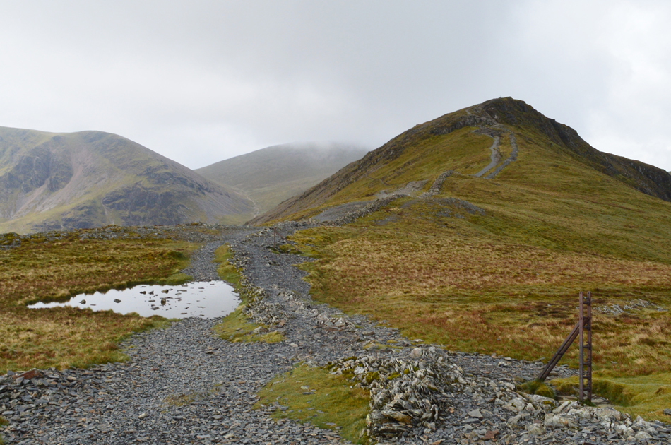
| Ascent of Kin. |
| The ascent through the woodland was short but steep which kinda prepares you for this next bit, the ascent of Kin, it's pretty steady all the way although it gets the blood flowing, it was around here I decided I'd had enough of sweating so I took my jacket off, rolled up my sleeves and got on with it. |
 |
| Grisdale Pike from Kin summit. |
Although it's been nearly three years since my last visit during the ascent of Grisedale Pike I always wander off path at Kin to take in this fabulous view of the ridge ahead, that's Sleet How up ahead which is part of the ridge walk below the summit. Grisedale Pike has no false summit but the ridge always feels like it's made up of two tiers, Kin being the first soon followed by Sleet How.
Hey-ho lets go. |
 |
| Just as forecasted. |
| The cloud is clearing nicely over the summit. |
 |
| Grisedale Pike as I head over Sleet How. |
| Mmm... I think I spoke to soon, lets see what develops. |
 |
| ...okay |
| Maybe the cloud has different ideas... |
 |
| That's better. |
| Here I pause to look back over Sleet How (foreground) and Kin in the distance beyond the trees. It was while here I studied Birketts Grisedale Pike north ridge walk which descends Sleet How then drops into Grisedale Gill via the fence line alongside Hospital Plantation (the wooded area on the left) The name Hospital Plantation derives from Lakeland View, a home at the side of the Whinlatter Pass which was once an isolation hospital for contagious diseases. |
 |
| Murky views over Outerside, Stile End, Causey Pike towards a distant Catbells. |
| |
 |
| Nearing Grisedale Pike summit. |
I'd stopped so many times either to take photos or study Hospital Plantation that this very sweet lady had caught up, then overtook me which if I'm truly honest she would have done anyway after the tell tale signs of her being an ex-fell runner started to show through like ascending with hands on hips, hands clasped behind the back all the while maintaining a constant and speedy ascent.
I only hope I'm still as fit when I reach her age. |
 |
| Hopegill Head from Grisedale Pike summit. |
The lady disappeared over the summit crest and I wasn't too far behind finding the summit cairn occupied by two walkers drinking from a flask who I'd been observing their ascent since Kin.
Summit hogging is my one pet hate but I say nowt but a cheery hello. The lady was by now descending the north ridge, hands firmly clasped behind her back. |
 |
| Hobcarton Head is just ahead with Eel Crag (Crag Hill) on the left and Grasmoor seen centre. |
| Hobcarton Head is actually un-named on the OS although Birkett claimed the name suitably as Hobcarton Head which sits at the head of the Hobcarton valley directly above Hobcarton Crags. |
 |
| Hopegill Head from Hobcarton Head. |
| Another chap who I'd seen from Sleet How was this chap who was ascending with a mountain bike above his head (seemed like very hard work!) By the time I reached Grisedale Pike he vanished off into the cloud and I caught up with him on the summit of Hobcarton Head, after a brief 'hi' he descended rapidly over Hobcarton Crags and then picked his bike up again for the ascent of Hopegill Head. |
 |
| Broody views back towards Grisedale Pike. |
| That's the Grisedale Pike north ridge seen slopping away over on the left. |
 |
| Descending towards Coledale Hause with impressive views of Eel Crag (Crag Hill) and Grasmoor. |
From Hobcarton Head I descend south westerly and I pick up the path which de-tours around/behind Hobcarton Head. I had a few brief sunny spells at this time which were most welcome which lead me to believe they were here for the duration.
If only!! |
 |
| Grasmoor and Grasmoor North Ridge seen over Coledale Hause. |
| That's the south slope of Sand Hill seen sweeping in from the right with the whereabouts of Pudding Beck bottom right. |
 |
| I concentrate on Eel Crag. |
| |
 |
| Descending into Coledale. |
| I must have been dawdling because the couple who had been enjoying coffee back at Grisedale Pike where now on my tail whose dog, a cheeky Spaniel named Harry often ran ahead of both me and his owners behind me, by the looks on Harry's jowls he was having a whale of a time. |
 |
| A close up of Force Crag Mine. |
| Force Crag Mine was only abandoned as late as 1991 and had mined Lead, and later Zinc since 1839. |
 |
| Force Crag and Low Force Falls. |
| It's been sometime since I last descended the path into Coledale and I had forgotten how rough in places (especially the mid section) was. I pass a young couple who didn't appear to be enjoying their ascent then I'm passed by a fell runner and his dog who ran as he was on air. Further down closer to Coledale Beck a trio of mountain bikers are about to start their own ascent first by pushing their bikes, later they too can be seen with their bikes above their heads. |
 |
| Looking back towards the head of Coledale with Force Crag below the dominance of Eel Crag (Crag Hill) |
| Well it doesn't feel like I've really broke a sweat today and for once that's fine, all that's left now is the blissful two mile walk back to Braithwaite along the old mine track. |
 |
| Nearing the end of the Coledale Valley. |
| I took this photo overlooking the village of Braithwaite with Skiddaw, Latrigg, Blencathra, Clough Head and the Dodds and even Great Mell Fell in the distance. |
 |
| Here I look back beyond the Gorse bushes towards Stile End, Causey Pike, Outerside, Scar Crags, Sail and Eel Crag (Crag Hill) |
| |
 |
| Braithwaite rooftops. |
| It's not very often I have the time to dawdle but today I did just that more so on the delightful two mile mine track back to Braithwaite where I walked boy like with my hands in my pockets even finding the time to tie in walking poles to my pack instead just carrying them like I normally would. I reach the gate above Braithwaite and I know just around the corner, beyond the car park barrier my car awaits but It had only been just over three and a half hours and although my walk was almost over I found myself slowing down even more not really wanting this walk to come to an end. |
|
| |
| Back to top |
 |
|