Loughrigg Fell from Rydal

22nd February 2020

With February almost written off due to Storm Ciara then Dennis my fell walking has taken a massive nosedive this month and with more stormy weather forecast for the rest of February I'm not sure If I'll ever get high enough to enjoy the Lakeland fells in Winter. David has been lucky enough to 'snatch' quite a few walks during the storm period whereas Rod and I have been housebound so last weekend we agreed that come hell or high water we'd be walking this weekend.

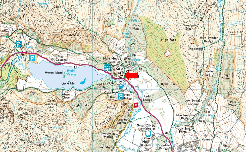
I came up with a walk where we'd gain Nab Scar from Rydal, then retrace back to Rydal via the Corpse Road before crossing the A591 from where we'd gain Loughrigg Fell, it was a great route given todays high winds and showers; that was until David noticed from the road that the Weir linking Grasmere with Rydal Water had flooded the footpath. It was no biggie we just needed to come up with a plan B which we agreed to summit Loughrigg Fell then drop into Ambleside and return to Rydal via Rydal Hall, to be fair as we all agreed, we just needed to get out and feel the wind in our faces.

 
Wainwright Guide Book Three
The Central Fells
Loughrigg Topographically, Loughrigg Fell is the corner-stone of the high mass of land lying south-west of the Rothay valley system, with High Raise as the loftiest point, but is almost isolated.
 

Overview
Ascent: 1,407 Feet 429 Metres
Wainwrights: Loughrigg Fell
Weather: A Cloudy, But Dry Start, Showers Later With Strong Winds Over The Summits. Highs of 8°C Lows of 7°C
Parking: Roadside Parking, Rydal
Area: Central
Miles: 6.2
Walking With: David Hall & Rod Hepplewhite
Ordnance Survey: OL6
Time Taken: 4 Hours
Route: Rydal Church - Pelter Bridge - Loughrigg Cave - Loughrigg Terrace - Loughrigg Fell - Lanty Tarn - Miller Bridge - Ambleside - Rydal Hall - Rydal Church
 

Parking Details and Map
Nearest Post Code: LA22 9LR
Grid Reference: NY 364 706
Notes: The roadside parking at the side of Rydal Church has always been a very popular place to start your walk especially those walking the Fairfield Horseshoe of visiting Loughrigg Fell, Rydal Hall and Rydal Tarn. There once was room for up to twenty cars plus but this was limited after Storm Desmond during the Winter of 2015 when the road and the drains where damaged resulting in limited parking. If you arrive early you shouldn't have any problems parking but if left late you may struggle. At the side of the Church there is an Honesty Box.


Map and Photo Gallery


Rydal Church 08:30am 7°C
It's a bright start but it's not to last, from Rydal Church we head back along the A591 towards Pelter Bridge.

The River Rothay had burst its banks at Pelter Bridge.
 

The results of Storm Ciara and Dennis.
We agreed it's going to take weeks of dry weather until river levels return to normal, only then can the clean up begin..

Pelter Bridge.
Luckily the car park and footpath on this side of the river are unaffected and we are able to continue with our walk.

A dash of sunlight over Nab Scar from Rydal Water.
It's probably just as well we weren't venturing too high today with high winds predicted over the summits, a few people I know through social media had attempted the Fairfield Horseshoe but were forced to turn back due to high winds.

Loughrigg Cave.
Looks like a camera club are setting up so we had a quick wander towards the back of the cave then left and got out of the way.

Walking towards Loughrigg Terrace.
More hints of sunshine.

The view over Silver Howe towards a distant Crinkle Crags and Bowfell.
It's looking like it could rain at any minute towards The Langdales.

The brief spell of sunshine continues as we take in the view over Grasmere towards Helm Crag, Steel Fell, the top of Dunmail Raise, Seat Sandal and Stone Arthur.
You can just make out the Weir in the bottom right of the photo which was part of todays intended route, the path on the other side of the footbridge is flooded which is why we had to change the walk.

More sunlight over Great Rigg.
 

Windermere and Esthwaite Water from Loughrigg summit.
If we were having trouble standing here I wouldn't want to be on top of Skiddaw right now, blimey it was windy enough to send you sideways.

High Pike, Low Pike, Dove Crag and Red Screes from Loughrigg Fell.
We left the summit and started to make our way towards Lilly Tarn where as you can guess, it was very wet underfoot.

The River Brathay had also burst its banks between Skelwith Bridge and Clappersgate.
It's difficult ro see due to the low light but within the trees below property had also been flooded.

Looking back on Loughrigg Fell as we approach Lilly Tarn.
 

The Fairfield Horseshoe and Snarker Pike from Loughrigg Fell.
 

Moody Lilly Tarn.
It was noted that the tree that once stood in the middle of the tarn has blown over with its branches now lying semi-submerged in the water.

The Fairfield Horseshoe.
 

Snarker Pike and Red Screes seen above Ambleside.
Taken during the descent from Lilly Tarn while on route to Miller Bridge, Ambleside.

Miller Bridge, Ambleside.
As expected the river levels around Miller Bridge were also high with flooding extending into nearby fields. The tarmac footpath/road which links Ambleside to Pelter Bridge remains closed due to flooding but there was still plenty of folk about enjoying a day out.

Low Pike and High Pike are engulfed in cloud as was the whole Fairfield Horseshoe.
Taken during a rather heavy downpour as we walked alongside Rothay Park towards Ambleside.

The cloud clears revealing snow on Fairfield.
What was falling as rain here at valley level was falling as snow across the higher summits.

Lots of water at The Grot.
 

Rydal Hall.
The sudden gust was sending the water pouring from the fountains in all directions and by the looks of it we're in for another heavy downpour. The good news is we are just minutes from our cars. Our plan B turned out to be a fantastic walk covering exactly the same mileage as our intended walk just less the height which, when it was as windy as today, was probably a good thing.


Back to top