|
Steel Edge, Wetherlam & Wet Side Edge from Tilberthwaite |
 |
 |
1st May 2023 |
 |
|
It's not unheard of for me to pack three or four pairs of gloves, more beanies than you can shake a stick at, and the odd pair of extra socks that have been in my pack so long now that I think they are past their sell by date. Come spring, however, it's time to shed the extra layers and replace them with extra hydration, sun cream, and energy drinks. But for some reason, low pressure has outstayed its welcome on the Lakeland fells, meaning I'm still carrying all of the above. I really do think it's time to stop weather watching and start relying on some good old-fashioned spring weather.
I should have walked on Saturday, but I was too burned out with work and relished a lie-in instead, which paved the way to cut my lawns and take Brad and Holly on an extra long dog walk. Sunday was a washout, it rained from dawn through to late afternoon, but Monday looked much drier. The initial forecast predicted a bright day, but the brightness edged into the afternoon, leaving the Lakeland fells in extensive cloud, Come what may, I was going to walk.
The Coniston fells were calling, and initially I'd planned to re-walk our 2019 Remembrance Day route from Seathwaite to Grey Friar, then head as far south as Brown Pike before returning to Seathwaite. It had been a route I'd longed to repeat, but maybe too long a walk in extensive cloud, which was when I remembered about this walk, which stems back to 2017 which seemed perfect for a day like today. |
|
| Wainwright Guide Book Four |
 |
| The Southern Fells |
| Great Carrs
Curved like a scythe, the shapely ridge springing form the fields of Little Langdale to the crest of Rough Crags and climbing gradually thence along the grassy rim of Wet Side Edge to a lofty altitude between deep valleys, has little to arouse interest until the mild excitement of boundary stairway skirting the edge of crags promise better things ahead. |
 |
|
|
|
| |
|
Overview |
|
|
| Ascent: |
2,946 Feet - 897 Metres |
| Wainwrights: |
3, Wetherlam - Swirl How - Great Carrs |
| Visiting: |
Hell Gill Pike |
| Weather: |
Extensive Cloud With Isolated Showers. Brightening Up PM. Highs of 16°C Lows of 9°C Freezing At Summit Level. |
| Parking: |
Car Park, Tilberthwaite |
| Area: |
Southern |
| Miles: |
9 |
| Walking With: |
On My Own |
| Ordnance Survey: |
OL6 |
| Time Taken: |
5 Hours |
| Route: |
Tilberthwaite – Above Tilberthwaite Gill – Steel Edge – Wetherlam – Swirl Hawse - Prison Band – Swirl How – Top of Broad Slack – Great Carrs – Wet Side Edge – Greenburn Beck – Low Hall Garth - Slater Bridge (Little Langdale) – Moss Rigg Wood – Tilberthwaite Farm – Tilberthwaite |
|
| |
|
Parking Details and Map |
|
|
| Nearest Post Code: |
LA21 8DG |
| Grid Reference: |
NY 306 100 |
| Notes: |
Nestled within the Yewdale fells Tilberthwaite car park is perfect for taking on Wetherlam and the Yewdale Fells. The car park is spacious but during peak season can fill up quite quickly, late arrivals maybe disappointed. Parking is free. |
|
| |
|
Map and Photo Gallery |
|
|
 |
| |
| |
 |
| Wetherlam and Steel Edge seen beyond Tilberthwaite Gill 8:00am 9°C |
As I was driving towards Yewdale most summits were below cloud, all except Wetherlam, which even had pockets of blue skies above it. Minutes later, as I arrived at Tilberthwaite those blue skies were beginning to disappear but the good news was that Wetherlam's summit remained clear. For a bank holiday Monday, the car park was surprisingly quiet, with just two other cars parked up, one of whom belonged to two women and their golden Lab who left with a 'morning' as I laced up.
It was cool enough to add a jacket but mild enough to keep the beanie and gloves close by should I need them later. With the exception of cutting the lawns and dog walking, I'd had a lazy day yesterday, and the climb out of Tilberthwaite brought my calfs and lungs out of hibernation mode. By now the two women were up ahead and had opted to take the path around the head of the gill rather than the path that descends in and out of the gill (you can see one side of the path over on the right) which was the right thing to do as the bridge had been washed away sometime ago and is still waiting to be replaced. I was only here back in December and had crossed the gill which, unlike today, wasn't in spate. I too, would opt for the higher path. |
 |
| Looking back on Tilberthwaite from Tilberthwaite Gill. |
| Between the drizzle and dense cloud pockets of sunshine would often break through which added to the cloud dramatics. |
 |
| Steel Edge. |
| I soon arrived at the base of Steel Edge, where I took in the impressive views of the ridge, crags, and rock buttress. |
 |
| Looking back on Blake Rigg as I begin my ascent on Steel Edge. |
| After crossing the head of Tilberthwaite Gill I caught up with the two women who were waiting to cross Crook Beck which, although not in spate, looked to be a tricky crossing with its deep pockets of water and submerged, slime covered rock. Watched on by the two women, I crossed the beck aided by my walking poles, trying not to make a hash of it. I was thankful to have succeeded emerging on the other side with just damp trouser bottoms. |
 |
| Dramatic views towards Holme Fell and Black Crag. |
| It's a pretty steep start as I weave my way up the lower section of the ridge which was holding onto water like a sponge. |
 |
| Looking down on Steel Edge. |
| Once the grassy bank was reached I was able to pick up my pace rather than labour through wet peat and swollen ground. I really enjoy the steep, twisting ascent of the upper ridge, including the two rock grooves. Give me steep and craggy any day. |
 |
| From the top of Steel Edge I took in the view towards Hen Tor and the top of Wetherlam Edge. |
| Not before paying a quick visit to the unamed tarns close by. |
 |
| Windermere from Lad Stones (south ridge) |
| There's actually three tarns found here but the smallest (beyond the craggy outcrop) had almost dried up. |
 |
| On the opposite side of the ridge... |
| ...Coniston Old Man immersed in cloud. |
 |
| Heading towards Wetherlam summit. |
| From Lad Stones there's still half a mile and 400ft to ascend to the summit where I found myself ascending into cloud, a bitter wind and pockets of drizzle. |
 |
| Wetherlam summit appears. |
| I was passed by a fell runner whose exposed legs looked red raw just just as my hands were starting to look and feel the same way I de-shouldered my pack and added a pair of gloves and my beanie. Jeeez welcome back Winter! |
 |
| Prison Band on Swirl How seen beyond Swirl Hawse. |
Summit time was kept to a minimum, but before I left, I noticed a trail race GPS tracker surrounded by a sponsor flag wedged into the summit cairn, but for now it was just me and a howling wind. I began my descent from the summit in drizzle and walked into a headwind towards Swirl Hawse while being flanked by Black Sails somewhere over my left shoulder. It was here I passed a solo walker, and despite the conditions, a cheery 'morning' was shared.
Back to the path labelled Keld Gill Head on my map, I passed a deceased lamb, its death a complete mystery other than a five pence size incision on the side of its stomach. A cut so clean it looked like it had been done with a surgeon's knife - I felt sad, this poor thing lying there in the wind, cloud, and drizzle. No photograph - instead, I wondered how it came to its untimely death, what made the cut, and why it was so high on the mountain when most lambs were still in the valleys. Could it have been separated and wondered up here from the Greendale valley below and died of exposure during the night before the Ravens struck. |
 |
| Looking down on Prison Band. |
I heard voices and the sound of rock falling well before I saw the dozen fell runners clambering down Prison Band, who were all in good spirits, including the girl I scared to death as we rounded the same crag.
Prison Band was the last 'real' ascent in todays walk, where I was brought back to basics. We all crave sunshine, but to ascend crag in thirty-meter visibility took me back to my foundations of fell walking, this was it; this was what I loved doing. It's just that every so often I get side blinded by blue skies when really, this is what it's all about. |
 |
| Swirl How summit. |
| Despite the cloud I knew I was close to the summit confirmed by a trio of fell walkers who were 'checking in' One of the fell runners studied a map which took them in to a world of cloud Brim Fell bound. I would have been happy to help but despite conditions, not one of them looked up from the map, they trusted their skill and lead the way. I really liked that. |
 |
| Top of Broad Slack. |
| I began the slight descent, leaving Swirl How behind and crossing the top of Broad Slack towards Great Carrs. I was exposed to the elements again in declining visibility but at the same time relishing every moment. |
 |
| Top of Broad Slack. |
| |
 |
| LL505 call sign 'S' for Sugar. |
| Through the mist and drizzle, the memorial cross appeared where, in conditions similar to today's, a Halifax Bomber crashed into Broad Slack resulting in the deaths of eight crew members. |
 |
| Great Carrs summit. |
I left the memorial and found my way back on the path, which, in good visibility, would offer grand views over the sweeping curve of Broad Slack towards Swirl How. There was no chance of that today. I arrived at the summit to find a solo walker drinking from a flask who offered to 'duck' his head down while I took this photo. 'no need, mate, I'll be on my way," and no sooner had I arrived, I'd left. |
 |
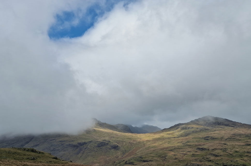
| The view beyond Hell Gill Pike towards Cold Pike. |
| With Great Carrs behind me I continued my descent flanking Little Carrs before witnessing gaps appearing in the cloud. After two hours of low visibility the site of Hell Gill Pike appearing was a huge highlight of the walk. |
 |
| Further down the ridge. |
| More dramatic views of Cold Pike appearing through the cloud. |
 |
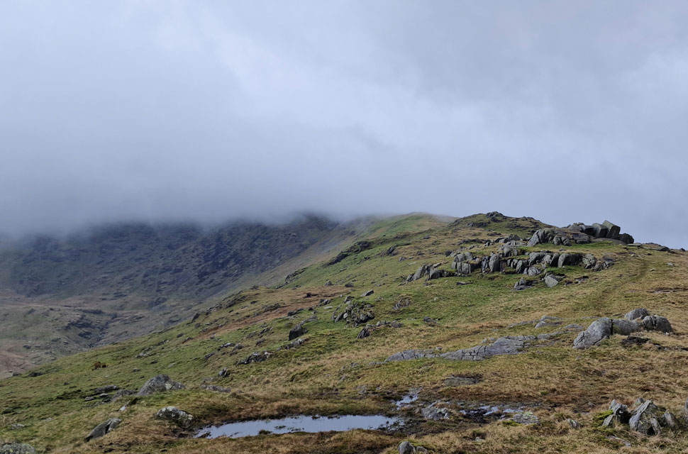
| Wet Side Edge comes into view. |
| Along with Greendale, Greendale Tarn, Lingmoor Fell and of course, Little Langdale Tarn. |
 |
| The view back up Wet Side Edge. |
| Towards Great Carrs and Broad Slack. |
 |
| As morning turned into afternoon. |
| Rays of sunshine poked through the cloud seen here over Pike O'Blisco. |
 |
| As the cloud lifts views begin to reveal... |
| ...Great Knott, Crinkle Crags and Bow Fell. |
 |
| Wet Side Edge. |
| With the head of Greendale (Broad Slack) appearing below the cloud over on the left. |
 |
| Great Intake prior to crossing Greendale Beck below. |
Although the cloud was lifting, it was followed by a sun shower and cloud so low it had almost followed me to the base of the ridge, but as soon as the showers had passed, it made way for white cloud that teased blue skies beyond. It was warming up now and before I made my full descent, I stopped to de-layer and sip hydration at will.
The base of the ridge opened up to swollen ground, which I followed as far as the corner of this wall, which descended steeply to the footbridge spanning the gorged Greendale Beck. From here, I officially enter Little Langdale by following the footpath seen over on the right, passing Little Langdale Tarn as far as the Ford at the head of Little Langdale Quarries. |
 |
| The Langdale Pikes and Side Pike from Bridge End. |
| |
 |
| Langdale Pikes close up. |
| |
 |
| Lingmoor Fell seen beyond Little Langdale Tarn. |
I continued along the path, passing through Low Hall Garth, which was once a climbing hut but now resides as a holiday cottage. As I continued along the path, I began to pass holiday makers enjoying the bank holiday who flocked to Slater Bridge posing for photos or just enjoying the welcome spring sunshine. Things were a little uglier as I passed the sty, which led up to Cathedral Cave where impatient large numbers of people waited to cross. It wasn't good viewing.
The high numbers continued as I made my way towards the footbridge, where I turned right towards Little Langdale Quarries and Moss Rigg Wood. The bank holiday had drawn the crowds to some of Lakelands most famous hot spots, but the footpath through the woodland contained its quietude where I was passed by just one fell runner. The woodland gave way for farmland, where sheep grazed and lambs dozed nearby. I was beginning to overheat, but with Tilberthwaite moments away, I decided to sweat it out. I passed through Tilberthwaite Farm before joining the tarmac lane towards Low Tilberthwaite where I was passed by a young family, the father racing with his youngest daughter. Beyond the stone wall, more sheep graze in the midday sunshine, and while it's very spring-like here in the valley, the summit of Wetherlam was still lost in cloud as it had been hours earlier. |
|
| |
| Back to top |
 |
|