 |
Illgill Head Wild Camp |
 |
 |
9th - 10th June 2023 |
 |
|
I hadn't planned to do a wild camp, but last weekend, while we were doing the Ramps Gill walk, David asked me how I was fixed for a wild camp. He explained that he could get Friday afternoon off, and all we had to do was come up with a location to choose from, of which there were many; sadly, Rod couldn't make it. My first reaction was to reply, "I want to wild camp Helvellyn" which is something that I'd wanted to do after reading Ron Black's "Night in Heaven." In fact, I'll go so far as to say that in Ron's memory, I'd like to replicate the route Ron took, with David sounding just as optimistic.
Days later, one evening whilst walking the dogs, I felt somewhat troubled knowing that given how nice the weather has been, we might not be the only ones camping on Helvellyn, which for me would ruin the experience, and I know it had been on David's mind too. Right there, I began to write an email to David suggesting that for now, we ditch the Helvellyn wild camp, and, after a few moments of thinking where else we could try, I typed the words 'IIIgill Head'. Instead of replying, David rang me, and I could tell by the enthusiasm in his voice that he was up for it too. We had the forecast, we had one of the best locations none of us had thought of before, and all we needed to do was to arrange the route. |
|
| Wainwright Guide Book Four |
 |
| The Southern Fells |
| The top of the fell is a smooth sheepwalk; these many acres of loose and shifting debris must therefore resulted from the disintegration of crags that, ages ago, rimmed the top of the fell: some rocks remain still in a state dangerous decay. |
 |
|
|
|
| |
|
Overview |
|
|
| Ascent: |
2,050 Feet - 762 Metres |
| Wainwrights: |
2, Whin Rigg - Illgill Head |
| Visiting: |
Irton Fell |
| Weather: |
Bright & Sunny Over Both Days, Gusty At Height Highs of 23°C Lows of 22°C |
| Parking Using x2 Cars: |
Irton Pike Car Park, Bowerhouse Bank, Santon Bridge - Roadside Parking, Greendale Junction, Wast Water |
| Area: |
Western |
| Miles: |
10 |
| Walking With: |
David Hall |
| Ordnance Survey: |
OL4 - OL6 |
| Route: |
Irton Pike Car Park - Irton Fell - Top of Greathall Gill - Whin Rigg - Illgill Head - CAMP - Straighthead Gill - Brakenclose - Overbeck Bridge - Road Back to Greendale Junction |
|
| |
|
Parking Details and Map Car Irton Pike Car Park, Bowerhouse Bank, Santon Bridge |
|
|
| Nearest Post Code: |
CA19 1UY |
| Grid Reference: |
NY 121 012 |
|
| |
|
Parking Details and Map Roadside Parking, Greendale Junction, Wast Water |
|
|
| Nearest Post Code: |
CA20 1EU |
| Grid Reference: |
NY 151 505 |
|
| |
|
Map and Photo Gallery |
|
|
 |
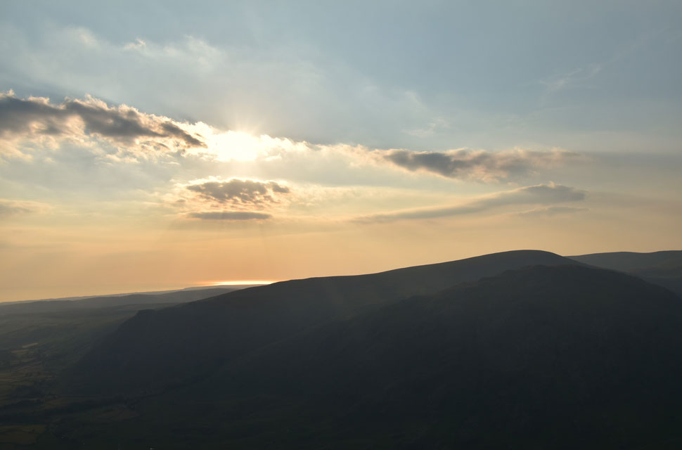
| Great Gable, Lingmell, Scafell Pike, Illgill Head and Whin Rigg taken from the road between Santon Bridge and Nether Wasdale 13:41pm |
| Making the use of two cars, we had come up with a linear route that would start at the car park below Irton Pike and end at the Greendale junction in Wasdale. While on route to meet David in Wasdale, I had this fantastic view of Illgill Head, and given that I was running well ahead of schedule, I decided to stop the car and take a few photos. |
 |
| Great Gable and Whin Rigg across Irton Fell 24°C 14:26pm |
We had arranged to meet at the Greendale junction at 14:30pm where I arrived half hour early to find David sat on a fold away chair next to his car. We had predicted this parking area to be busy and were surprised to find there were still quite a few places left. Wast Water was especially busy with camper vans, paddle boarders and even divers setting up on the shoreline as we swapped David's gear into my car. It was a hot and dusty afternoon, and we had given ourselves four hours to reach Illgill Head over a distance of just four miles. It doesn't take a genius to work out that's less than a snail's pace, which was exactly why we had allowed it given the heat and the weight we were carrying.
We hung about in Wast Water for a few extra minutes before deciding to head to the car park below Irton Pike; it's a place I know well but have never parked there. It only took about twenty minutes to arrive where we found the car park had just one place left to park, and even that meant David had to reverse at a peculiar angle, which left David's car open to being double parked. I spotted a clear area close to the entrance, even if it meant David parking within a whisker of the trees. At least the car would be safe.
In the middle of the car park, a middle-aged couple and their staffy were getting ready to leave, and as they passed, we swapped pleasantries on the hot weather as packs were transferred from boot to car park; blimey, they weren't getting any lighter, and they certainly wouldn't shoulder themselves. We had opted to miss summiting Irton Pike and instead follow the track below its tree rich east flank as far as Irton Fell. With packs shouldered, we left the car park and began the steady but short walk up along the track, sometimes stopping to take in the view over Muncaster, and the Devoke Water Fells. |
 |
| Aberdeen Angus cows, Irton Fell. |
We bumped into the couple again close to the gate in the previous photo who were returning to the car park because they'd took the wrong path while looking for Irton Pike summit. "No need to head back I explained you can pass through the plantation 'pointing towards the trees' which will lead you directly onto the summit.
Even though they had only been out for less than half an hour, they had concerns for their dog, who was panting heavily in the heat. The couple went on to explain that this was a dry run as they were planning to walk up Scafell Pike in a few days. We left the couple, who then headed into the plantation where at least the dog could take advantage of the shade. |
 |
| Yewbarrow. Kirk Fell and Whin Rigg from Irton Fell. |
The heat was peaking, but we were coping well with our loads, often stopping to take in the view or to chat despite being mobbed by horseflies. Although neither of us said it, I'm sure we were both thinking, "I hope the horseflies aren't this bad on Illgill Head." |
 |
| We pass the top of Greathall Gill. |
| With views towards Lank Rigg, Buckbarrow, Seatallan, Haycock, Scoat Fell, Red Pike (Wasdale) and Middle Fell. |
 |
| Looking back on Greathall Gill towards Irton Fell with the Cumbrian coast beyond. |
| Besides the couple, we hadn't seen anyone until we were passed by a woman and her dog who had just descended Whin Rigg and 'hi's' were exchanged. We still had loads of time to spare, so when David said, "There's nothing stopping us from spending an hour on Whin Rigg," I jumped at the chance. |
 |
| Views beyond Wast Water towards Buckbarrow, Seatallan, Haycock, Scoat Fell, Red Pike (Wasdale) Pillar, Yewbarrow and Middle Fell. |
| We soon arrived at Whin Rigg summit, where we found a spot out of the wind and de-shouldered our packs before being joined by a young couple who did the same a short distance away. We killed time by chatting and taking in the fantastic views over the Western Fells, Seascale Nuclear Station and beyond. Well over an hour had passed before we decided it was time to leave and head for IIIgill Head summit. |
 |
| Pillar, Yewbarrow, Kirk Fell, Great Gable, the Scafells and Slight Side from Whin Rigg. |
| Time for one last photo before we leave. |
 |
| Scouting for a place to camp, Illgill Head. |
| We had known about the wind which had been forecasted between 10-15mph which we were fine with but as we crossed the saddle between Whin Rigg and Illgill Head it was noted the wind was blowing beyond 20mph and with a nightime temperature in the low teens ideally we need to find a sheltered area which isnt easy to come by on Illgill Head. |
 |
| Kirk Fell, Dore Head, Great Gable, Lingmell, Scafell Pike, Sca Fell and Slight Side from Illgill Head lower cairn at 1,970 feet (604 metres) |
| We scouted the area east of the lower cairn, where we found craggy, scattered limestone above hollows, but the grassy tussocks underfoot meant it was too lumpy to set up camp. We tracked off path and headed back towards the lower cairn when, at almost the same time, we spotted the hollowed area seen left of the cairn. "Do you see what I see, David?" David was off like a bullet. |
 |
| Red Pike (Wasdale) Pillar, Kirk Fell, Dore Head, Great Gable, Wasdale Head and Lingmell NY 167 050 |
| Heart rates increased the closer we got to what turned out to be a grassy shelf about 100 feet nor-west of the main summit cairn, it wasn't just ideal it was perfect. |
 |
| Pitched up and ready for bait 18:30pm |
Tent locations were fixed, and we set about pitching the tents, which should have only taken us no more than ten minutes but dragged on because, unbeknown to us, the ground underfoot was rocky and we couldn't stake our tent pegs, forcing us to shift locations slightly even if it meant the pegs were going in almost horizontally.
There was only a slight breeze when we broke out for bait not quite believing how good a location we had found. Mind you, it's a good thing none of us are sleepwalkers with vertical drops above High Iron Crag just twenty yards away. After we had eaten, it was time for the first of two scouts around the area, the first of which took us towards the north east cairn at 1,918 feet (590 metres) where as the evening progressed, light was beginning to be replaced by shade as it inched its way up the valley.
David spotted a couple of walkers heading back to Wasdale Head from the direction of Burnmoor Tarn before we decided to head back to the tents, absorbing the silence as the Lakeland fells turned in for the the evening. |
 |
| Watching the sun inch down over the Irish Sea beyond Middle Fell, Buckbarrow and Seatallan 19:55pm |
| We returned to camp and settled down watching the light slowly being drawn from the valley below. |
 |
| Looking back on our camp location as we set off on another scout 20:16pm |
| Sitting idle got the better of us so we set off for another scout this time along the head of The Screes. |
 |
| Sunset from lllgill Head lower cairn. |
| With Seatallan over to the right. |
 |
| Looking down on Wast Water with Bell Ribb seen in the foreground. |
| Not wanting to miss the sunset we decided not to walk over the head of The Screes instead we found a sheltered spot from above Bell Ribb and Vickers How. |
 |
| Slowly sinking into the Irish Sea. |
| |
 |
| Golden hour. |
| Shade had succumbed to much, if not most of the Wasdale valley below allowing us to experience that golden light higher up as we made our way back to the tents watched on by some very curious sheep. |
 |
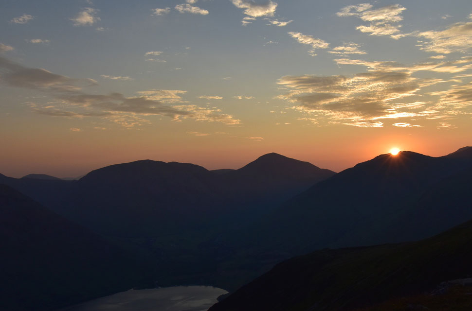
| Sun setting 21:28pm |
| Due to sun setting behind Seatallan we would lose sight a good fifteen minutes before it was due to set around 21:45pm. |
 |
| Dusk. |
| The sun fell behind Seatallan leaving a fiery afterglow extending across the horizon from west to east. Here we take in the view towards Seascale Nuclear Power Station whose lights had been flickering on for the last ten minutes. Venus can be seen in the night sky towards the right. |
 |
| The afterglow 22:26pm |
Despite the wind and drop in temperature, it was difficult to tear ourselves away from the spot, which was momentarily ruined by the sound of loud music, David and I looked at one another first, thinking, "Did you hear that?" Dusk was settling, and although we had light, we wouldn't if we were going to explore where this music was coming from.
The music faded, and silence returned, only to be disturbed again by the same music: "Where the hell is it coming from?" It sounded like it was around the summit lower cairn area, or at least in that direction. The music came and went, and we came to the conclusion that it was being carried, possibly from as far as the Woolpack Inn in Eskdale where live bands are known to play. Incredibly, it wasn't just the music that was on our minds the increasing strength of the wind was too. |
 |
| Time to turn in 22:44pm |
We had previously added extra layers due to the fact that, along with the temperature drop, it had gotten significantly windier. Down jackets were added, which allowed us to soak up the last of the light before we made the snap decision to 'turn in," by which time we could only just hear ourselves talk over the wind.
We turned around towards our tents, which by now were being funnelled by the wind directly off the summit, oh dear, nowt I could do except turn in. |
 |
| Sleep didn't come easy 2:42am |
I was dog tired when I turned in - so tired in fact that I thought my sleep wouldn't be affected by the wind. I was looking forward to sleeping even as I slid myself into my sleeping bag, extending one arm above my air mattress and the other, alongside my chest. The wind was relentless, rat-a-tat tatting like a machine gun against the outer skin of my tent, I knew my tent lines were tought but it made no difference. Sleep came again, but I was semi-conscious throughout, thinking I was sleeping and listening to the wind. Jesus, this was not forecast. Oddly, I craved the protection my tent gave me - just two layers of nylon that felt like steel, I took a strange comfort from it.
We didn't agree on a time to get up to have a star gaze; whichever one was up first was the usual method. Dazed, I unzipped the door of the tent and felt a blast of air in my eyes. The pillow of my airbed was almost touching the entrance anyway, so I flipped over onto my back to see what stars I could see and let my eyes adjust to the darkness; sadly, none. "David, are you up?" "Yeah, David replied." "Fancy a walk around?" "Are you out and about, Paul?" "Not yet, but I soon will be," I replied. With my head torch on, I eased myself out of my tent and slipped into boots, only bothering to tie the laces around the tops instead of through the hooks. I was groggy from not sleeping, and I suspect David was too.
I found my feet and remembered how close we were to the edge, so I backed up towards the ruined wall, where I was joined by David. The first thing we realised was that Wasdale does not sleep, with the mini-buses of Three Peakers heading towards Wasdale Head before sighting the head torches of those who had already summitted as they made their way back down. |
 |
| Kirk Fell, Great Gable, Lingmell and Scafell Pike 2:45am |
After a quick chat we both agreed that we had only drifted in and out of sleep at best and yet despite the lack of sleep it was worth it just to experience Wasdale Head in the dead of night.
The lights of Wasdale Head could be clearly seen, as could the lights from Greendale Farm but nothing from Bowerdale Farm while to the west Seascale Power Station was lit up like a small town. Our head torches seemed to be attracting the attention of whoever was below on the Lake Road whose head torches gazed back quizzically. |
 |
| Dawn 4:29am |
We'd returned to our tents, where I slid my mobile phone into a net pocket that I'd never seen before. Great, now I can see the minutes tick by, so I flicked the phone around and, for good measure, turned on my side and closed my eyes, during which time I was sure I could feel the wind lifting the lower half of my tent but in hindsight I'd probably dropped off and was dreaming it.
Still feeling groggy, I woke up and turned my mobile phone back around. It was 4:40am I could see light entering the tent through its entrance. I grabbed the zip and pulled it half the way around, the same for the outer zip, and poked my head out the tent, flipping eck, it's Dawn. |
 |
| Sun rising 5:03am |
| The sunrise began at 4:40am as we began our kit down, helping each other to fold our tents in the wind that had now lessened into a strong breeze. It took another 23 minutes for the sun to climb above Lingmell while witnessing one of the fastest sunrises ever. You can actually see it moving. What an incredible few moments. |
 |
| Taking it all in. |
| |
 |
| Almost above Lingmell now. |
| With the tents down we began to pack up which we have got to an art from camp to ready to leave in around 15 minutes. |
 |
| Lingmell sunrise. |
| Both David and I follow the website SunCalc.net which provides information on sunrise, sunset times and its location on any given day of the year. We had already researched where the sun would set and where it would rise, right over Lingmell. What a brilliant tool. |
 |
| David, IIIgill Head summit. |
| With camp packed up and one final sweep of the area we made our way towards Illgill Head summit whislt my legs protested at having not woken up yet. |
 |
| Yewbarrow, Pillar and Kirk Fell as we head towards Brackenclose 6:26am |
We left the summit and began the steady descent down Illgill Head northern flank as the sun continued to climb, surrounded by sheep and bleating lambs. We look east and spot tents next to Burnmoor Tarn. It now dawned on us that the music we had heard last night must have come from these tents, which exactly matched the location we could hear the music from. Bastards, we sighed. |
 |
| Looking back on IIIgill Head from the entrance to Wasdale Head Hall Farm. |
| The conversation turned to morons who had been playing the loud music, which had the potential to wreck our descent had it not been for the mooing sheep that thought it was a cow that we passed on the lower slopes of IIIgill Head. It was absolutely hilarious! |
 |
| IIIgill Head, The Screes and Irton Fell from the Lake Road. |
| |
 |
| The Screes and Irton Fell from the Lake Road 7:19am |
Brackenclose was awash with activity, mostly three peakers returning to their mini-buses as drivers and competitors looked on. By the time we had crossed Lingmell Beck we were stepping aside for mini-buses leaving Wasdale for Fort William, rather them than me. We reached the Lake Road, where I kicked my feet into the back of my boots, ready for the two and a half-mile walk back to the Greendale junction all over smooth tarmac. Clouds were beginning to build over the Scafells consequentially casting the valley in shade for a mile or so, but with the morning temperature already in the low twenties, you wouldn't think it. We were soon passed by a young solo girl who, after sharing a morning, uttered the words, "It's going to be a sticky one." We smiled and agreed. Overbeck Bridge came next, where last night, we had spotted a camp fire. Really, in this heat, the place is like a tinder box, but sadly, it doesn't seem to sink in.
By now the girl had disappeared as we passed over the cattle grid at Netherbeck Bridge as I took in the view towards Bowderdale Farm. Still in shade, the road climbed gently as I looked back on Yewbarrow where I spotted the girl climbing the south ridge. "Good on her great ascent," we uttered. " Cars and mini-buses came and went; the car park at Wasdale Head and Brackenclose must surely be full by now and its not yet 7:30am frightening we agreed. Legs awake but feeling the mileage; I need fuel. The sun reappeared, illuminating the whole valley in morning sunshine. It was hot again, and with the car just a few hundred yards away, we arrived back to find a chap reading a book in the car parked next to mine.
Packs de-shouldered, my back relishes the weightlessness as I route around my boot looking for the spare Lucozade Sport I'd left in there the previous day. Heat increasing, sticky, and humid, I thought about the girl heading up Yewbarrow which would be a struggle for the fittest of athletes. Boots swapped for mids now as we ease ourselves into the car and switch the air conditioning to full power. Against the traffic, we drove back to the car park below Irton Pike finding it empty with the exception of David's car. Amid the horseflies, we arranged our next walk as I looked down at the ground where I placed my pack before shouldering it yesterday afternoon, then at the short rise through horsefly-infested trees we took before we reached the track, which was exactly the moment I realised it was over and I felt my stomach drop. |
|
| |
| Back to top |
 |
|


