|
Helvellyn by the Edges |
 |
 |
9th August 2023 |
 |
|
I had two more walks planned for the week, one of which was an exact replica of a route I followed onto Sca Fell via Piers Gill and Deep Gill back in Summer 2014. Back then, I was on the wrong side of an incorrect forecast and ended up completing the route in fog so low I could barely see the treetops. For me, that walk was the pinnacle route onto Sca Fell, should you have the legs for it, but I was sidetracked after David Rod and I had planned a wild camp for this Friday night where we would hopefully catch the Perseid Meteor shower, but with rain forecast through the night, we had to shelve the wild camp.
The best of the forecast was for Wednesday (today) and Thursday, and initially I turned down the offer to join David and Rod tomorrow to walk a high-level circuit above Troutbeck, a walk that gained over 4,000 feet of ascent over 14 miles. It sounds like a cracker, but with my Sca Fell walk planned the day before, I might be biting off too much. The more I thought about the Troutbeck walk, the more I liked it, and I emailed David and Rod back, explaining I'd love to join them. The trouble was, with the Sca Fell walk shelved I now needed a less demanding walk, and seeing that I hadn't traversed Striding Edge in over four years (I can't believe it's been that long), what better way to spend the day than on one of Lakelands most exhilarating edges. |
|
| Wainwright Guide Book One |
 |
| The Eastern Fells |
| The gap in the wall -a familiar object on this route. It is a sight during the long climb along the flank of Birkhouse Moor, and it is always reached with thankfulness. |
 |
|
|
|
| |
|
Overview |
|
|
| Ascent: |
2,950 Feet 899 Metres |
| Wainwrights: |
Helvellyn |
| Weather: |
A Bright Start Clouding Over By Mid-Morning. Moderate Winds Where Exposed. Highs of 21°C Lows of 16°C |
| Parking: |
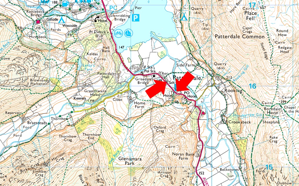
Patterdale Village |
| Area: |
Eastern |
| Miles: |
7 |
| Walking With: |
On My Own |
| Ordnance Survey: |
OL5 |
| Time Taken: |
5 Hours |
| Route: |
Patterdale - Grisedale Lane - Grisedale Brow - Hole-in-the-Wall - Striding Edge - Helvellyn - Swirral Edge - Red Tarn - Hole-in-the-Wall - Grisedale Brow - Patterdale |
|
| |
|
Parking Details and Map |
|
|
| Nearest Post Code: |
CA11 0NW |
| Grid Reference: |
White Lion Hotel - NY 395 315 - Patterdale Primary School NY 394 516 |
| Notes: |
Patterdale alongside Glenriddging acts as a hub for the eastern and far eastern fells yet unlike Glenridding Patterdale doesn't have a centralised car park. With this said parking in Patterdale, especially during the height of Summer can be a problem with only two main sites to leave your car. The first is very popular with fell walkers which is just opposite the White Lion Hotel, here you will find a short layby with room for up to five parked cars. Parking is free. The second place to park is found just outside Patterdale Primary School where you can park on the kerb right outside the School, here you will find spaces for around three to four well parked cars. Parking is free. |
|
| |
|
Map and Photo Gallery |
|
|
 |
| |
| |
 |
| Birks, St Sunday Crag, Steel Fell, Dollywagon Pike and Nethermost Pike from Grisedale 16°C 8:00am |
| Today was the first time I had driven over Kirkstone Pass, which had been closed due to the excavation of new drainage culverts, stone walling, and finally a re-surface, which will be completed around the end of September. I only just managed to park outside Patterdale Primary School, edging my car into the last available space without blocking the school gate, which someone would later do upon my return, but more on that later. Apart from the odd passing car and jogger, it's a lovely quiet morning, and I'm able to soak up my surroundings under the bluest of skies. Bearing in mind that I have a big day ahead of me tomorrow, I kept today's walk to a minimum, opting to skip a summit of Catstye Cam due to logistical reasons. Others might call me a lazy bugger, and I wouldn't blame them.
I locked the car and made my way towards Grisedale Lane, passing Patterdale Church yard and the home of Patterdale Mountain Rescue on the opposite side of the road. From the direction of Glenridding, three walkers checked their maps before turning right onto Grisedale Lane, who I followed until we reached the metal gate where views into valley instantly opened up. The three walkers opened the gate, which left just me turning right over Grisedale Beck before I began the slog up the steep grassy slope, where I was treated to more views of the Grisedale valley. On reaching the next gate, I found that it had been closed using a thick wooden post. I didn't know why, but off to the right, I used a second gate to gain access to the footpath above Grisedale Brow. |
 |
| More views into the heart of the Grisedale valley. |
| What a glorious morning. |
 |
| Birks, St Sunday Crag, Fairfield, Steel Fell, Dollywagon Pike and Nethermost Pike from the path. |
| I traced the three walkers as they made good pace through the valley, losing sight of them after they passed through Crossing Plantation (centre left), keeping my eye on the dark cloud seen far right, which looks to be right over Helvellyn summit. |
 |
| Striding Edge, Helvellyn, Swirral Edge and Catstye Cam from Hole-in-the-Wall. |
| Incredibly, I had the path from the valley floor all the way to Hole-in-the-Wall to myself, where it soon became apparent that high-level clouds were replacing the sunshine. Oh well, it was good while it lasted. It was also here that I noticed quite a few walkers heading from the direction of Birkhouse Moor having ascended from Glenridding.
Counting two large groups heading towards me, I hung around for a while, taking photos and enjoying the views. When the first group arrived, they de-shouldered and, like me, added extra layers due to the wind chill. The second group was still a distance away, and satisfied with the gaps, I made my way towards Striding Edge. |
 |
| Red Tarn comes in view. |
| As did Lower Man seen beyond Swirral Edge, that's Catstye Cam over on the right, but you already new that. |
 |
| Helvellyn from Striding Edge. |
| On reaching Low Spying How I was joined by this fell runner who seemed to appear from nowhere! |
 |
| Robert Dixon Memorial, Striding Edge. |
The Memorial reads - In memory of Robert Dixon of Rooking, Patterdale who was killed on this spot on the 27th day of November 1858 following the Patterdale Foxhounds. |
 |
| Striding Edge. |
| I'd already been passed by two young lasses who skipped past me like I was stood still, now't like the young un's to make us old un's feel old! |
 |
| Living on the edge. |
| The group I'd left back at Hole-in-the-Wall have now joined the ridge from Low Spying How. |
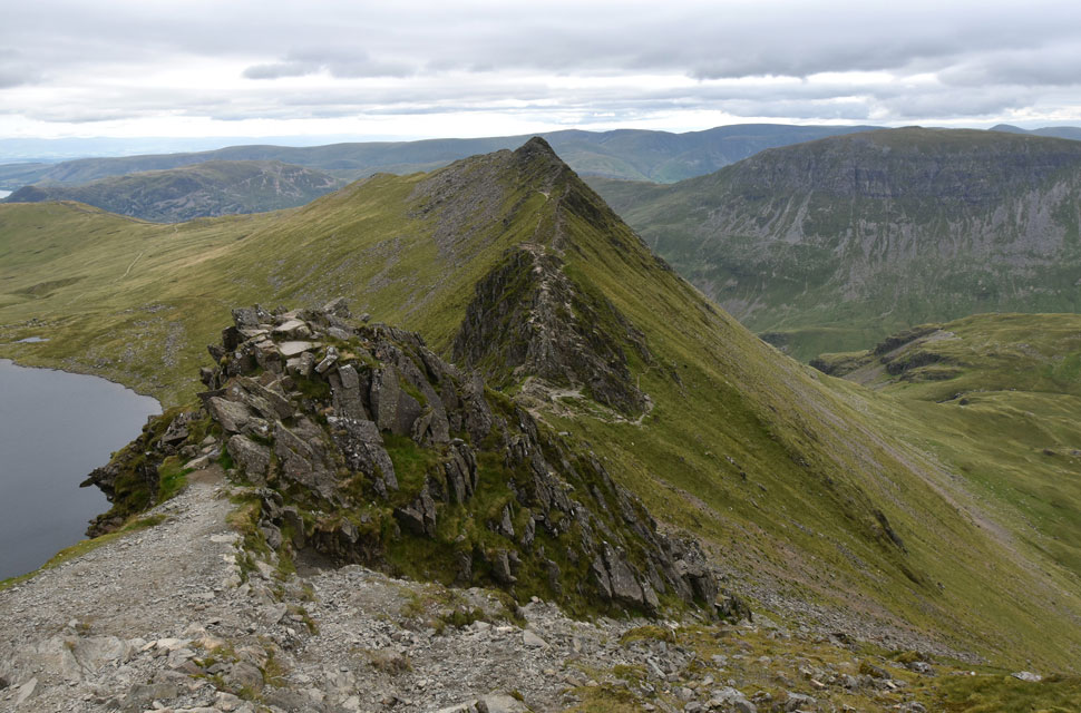 |
| Striding Edge from High Spying How. |
| With my traverse over, it was now time to enjoy the climb up the headwall, which was just as eroded as I had remembered it, passing a young couple who I stopped to have conversation with. The lad went on to say that this was his first traverse of Striding Edge, while his girlfriend added that she was scared of heights. My first reaction was to congratulate her, but I was left baffled as to why anyone would bring someone up here if they were scared of heights. It could have gone terribly wrong for the young girl had she gotten herself cragfast or worse, resulting in another thoughtless call out for MR. |
 |
| The Charles Gough Memorial. |
| Found at the top of Striding Edge. |
 |
| Fairfield, Great Rigg, Dollywagon Pike, High Crag and Nethermost Pike from Helvellyn summit. |
| I made my way towards Helvellyn's summit watched on by walkers enjoying time out at the cross shelter. It was here I passed a walker who was feeding a large seagull, the first gull I'd seen at Helvellyn's summit. |
 |
| Helvellyn summit plateau from the summit cairn. |
| With Swirral Edge leading off down to the right. I'm not sure if the large group at the top of Swirral Edge is waiting to descend or if they just arrived at the top; either way, I'm hoping they make a move soon. |
 |
| Looking down on Red Tarn and Striding Edge from Helvellyn summit. |
| I made my way across the summit plateau to a deserted trig point, which would only stay deserted for another twenty seconds before a family and their dog arrived. I was lost in my own world for those few moments and nodded a hello to the family as I made my way towards the top of Swirral Edge. |
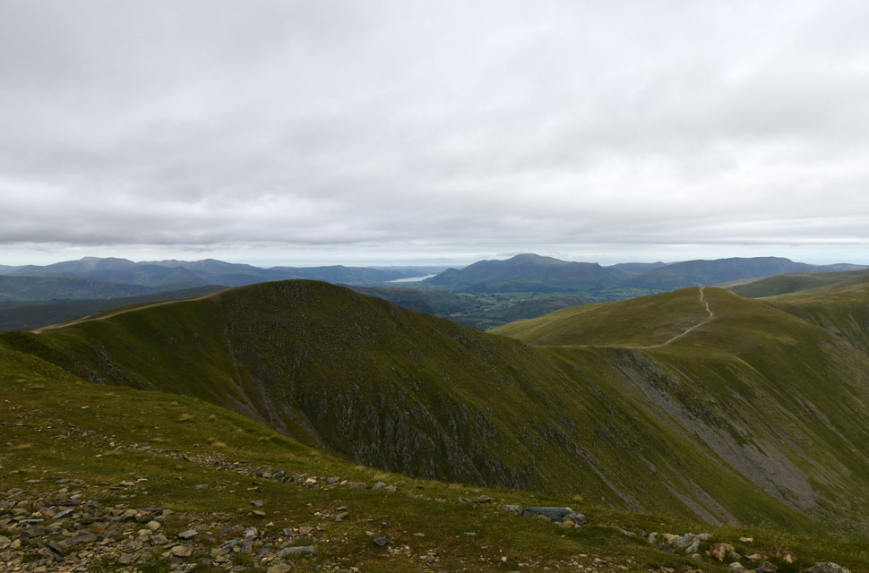 |
| From the top of Swirral Edge. |
| I look over Brown Cover towards Lower Man and White Side. |
 |
| Descent on Swirral Edge. |
| The large group had begun their descent, whose voices I could hear beyond the rock tower below. I usually choose to descend left of the rock tower, but after my last descent, all be it four years ago, I found the ridge incredibly eroded, so today I descend right, which is the rockier but more stable descent. |
 |
| Swirral Edge. |
| With Brown Cove seen beyond. |
 |
| Looking back on Swirral Edge. |
| It was nice to come away with a little Swirral Edge grit under the finger nails. |
 |
| Looking back on Striding Edge, Swirral Edge, Lower Man and Catsye Cam from Hole-in-the-Wall. |
| Whoo whoo the sun has come out! |
 |
| Descending back through the Grisedale Valley. |
| With Striding Edge behind me, I began my descent, taking in the view over Red Tarn towards the crowds now traversing Striding Edge, some of whom were gathered above the Bad Step at the end of the ridge. I hate seeing walkers waiting here. The two girls I had followed over Striding and down Swirral hooked a left alongside Red Tarn Beck while I crossed the Beck at the tarn's outflow before making my way towards Hole-in-the-Wall. Hoards of walkers were now gathering at this meeting point, and with more on route from Glenridding and Patterdale, the sensible in me felt like telling them to shake a tail, make a move, and create gaps so they could enjoy their traverse safely, but I kept quiet.
Two walkers were eating lunch below Hole-in-the-Wall, whom I passed before making my way down the stone staircase. As I inch my way back into Grisedale, more walkers are heading towards me, and hi's and hello's are shared as we pass one another. As I continue my descent, each step causes the backs of my toes discomfort, which I later trace to my gel insoles being too bulky for my boots. I perservere. "Excuse me," asked two young girls, "how far to Red Tarn?" They were half the way up the path, and I was half the way down. "See that wall" pointing to the Hole-in-the-Wall. "You just have to climb to that point." "Red Tarn is a ten-minute walk beyond; you can't miss it." The girls thanked me as I continued my descent, pressure still building in both boots. I must have passed another dozen walkers, all friendly, before the silence of the valley is shattered by shouts of yeehaa's from across the way: "Where's all that noise coming from?" as I scour the valley below. As it turns out, the screams are coming from youngsters aided by mountain leaders rock climbing the steep-sided crags below Birks.
Hot and humid with intermittent sunshine. I reach the valley floor, cross Grisedale Beck, and rise back to the metal gate, which I open to allow a Post Office van through, for which I am thanked kindly. Grisedale Lane now canopied by Waterfall Wood, trees, cascading water, and repeat. I love these gorged woods. I left Grisedale Lane and passed Patterdale Mountain Rescue before crossing the road bound for the Primary school just yonder. I spot my car, but it's hemmed in by some thoughtless person who thought it was OK to ignore the 'do not block the gate' sign and shoehorn his or her car so close to mine that their rear bumper is only a few centimetres from my front bumper, but for now all I can think of is removing my boots. Laces untied, I ease both my boots off, and the pressure releases instantly. Has my plantar fasciitis returned? Nope, your bloody insoles are too big. What a great day, though. |
|
| |
| Back to top |
 |
|