|
A Wasdale Horseshoe |
 |
 |
27th April 2024 |
 |
|
Other than working this morning, I had no plans for Saturday afternoon, but my lack of free time must have gotten the better of me because by 8am Friday morning I was planning this walk. I think it was back in May last year during our Bretherdale walk when David mentioned that the Shap Falls are a great place to visit where you don't usually need to arrive early to park, as their lack of popularity means that, like I did today, you can arrive by mid-afternoon and be guaranteed somewhere to park on one of the two large laybys at Shap Road Summit.
I left work at exactly 12:00pm and with hardly any traffic to contend with I unwound during my drive north and despite leaving work just just over an hour ago by the time I arrived at Shap Road Summit I was in fell walking mode. No matter the time of year, understandably, the summit road is exposed to the wind, and despite the sunshine, it was feeling a tad on the cold side as I began my kit up watched on by an elderly couple further up the layby who had stopped to have a cuppa. With the gaps in this month's walking calendar visibly wide it seems a while since I last did a fell walk on my own in an area of Lakeland known for how quiet it is, and after that had sunk in, this afternoons wander was starting to feel special already. |
|
| Wainwright Guide Book |
 |
| The Outlying Fells |
| Here is featureless desolation, and solitude, and silence; and if not for that once-busy ribbon of tarmac, the A6, this would seem a no-mans-land, a wilderness relieved by a few stone walls. |
 |
|
|
|
| |
|
Overview |
|
|
| Ascent: |
1'200 Feet - 366 Metres |
| Outlyers: |
4, Whatshaw Common - Little Yarlside - Great Yarlside - Wasdale Pike |
| Weather: |
Sunshine & Cloud With Fresh Winds at Height. Highs of 10°C Lows of 10°C |
| Parking: |
Parking Spaces A6, Shap Road Summit |
| Area: |
Far Eastern |
| Miles: |
6.2 |
| Walking With: |
On My Own |
| Ordnance Survey: |
OL7 |
| Time Taken: |
2 Hours 45 Minutes |
| Route: |
A6 Shap Road Summit - Whatshaw Common - Wasdale Mouth - Little Yarlside - Great Yarlside - Wasdale Pike - Wasdale Head Farm - A6 Shap Road Summit |
|
| |
|
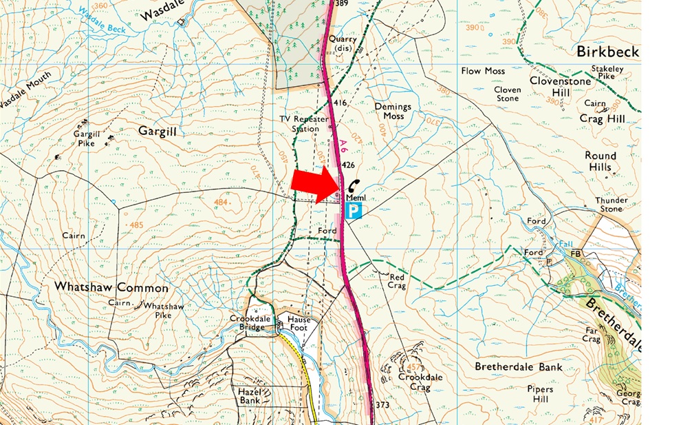
Parking Details and Map |
|
|
| Nearest Post Code: |
LA8 9LG |
| Grid Reference: |
NY 553 706 |
| Notes: |
The parking spaces are found about two and half miles south of Shap village at Shap Road Summit where a plaque stands in memorial to the drivers and crews who made the building of the A6 possible over Shap Fell at 1,350ft above sea level. There is room for around eight to ten well parked cars. Lookout for the Repeater Station and the many Electric Pylons which is where you will find the parking spaces. Parking is free. |
|
| |
|
Map and Photo Gallery |
|
|
 |
| Long Fell and Pink Quarry from Shap Road Summit 11°C 13:10pm |
| It's just me, the wind, and the old couple as I kit up behind the car, not quite knowing whether to wear my Rab stretched hoodie or keep things simple and go with a technical T and my Alpkit softshell, which won in the end. I'm back to wearing long trousers again, which will help against the notoriously boggy sections of the route. Hopefully, I won't need my gaiters, which get left in the boot. I walk past the couple who were still supping tea from a flask before sighting the gate up ahead, where I need to turn right towards Whatshaw Common. |
 |
| The view South towards Ashstead Fell, Mabbin Crag and the Whinfell Ridge. |
| I joined the track bound for Whatshaw Common and noticed the track had been churned up by tracked machinery, which extended all the way to the summit. Just in case you were wondering how boggy it was, it was actually dusty underfoot, but I don't think it's going to remain that way for long. |
 |
| Beyond the wall, the Crookdale Valley while up ahead are Little and Great Yarlside. |
| I was passed by an elderly chap soon after summiting Whatshaw Common, who advised me to steer clear of the bogs below its shoulder. The chap went on to say that he'd just sank up to his knees and advised me to go as far right as I could. Once I arrived at the bog, I jokingly told myself that I only needed to avoid the hole the chap's legs had left, which I did my best to spot but found nothing! I did take his advice and gave the bogs the widest berth I could, while treating my boots to a good soaking. |
 |
| Splendid views... |
| Over Wasdale Mouth. |
 |
| High House Bank and Robin Hood. |
| Seen over the Crookdale Valley. |
 |
| Another view into Wasdale. |
| Not wanting to curse it but I was loving the extra hours of sunshine as I'd expected to be walking under grey cloud by now. |
 |
| Wasdale. |
| Wasdale Pike, todays final summit can be found to the left along the ridge line from where I'll descent back into Wasdale towards the ruins of Wadale Head Farm. |
 |
| Looking back on Little Yarlside. |
| As I begin my ascent on Great Yarlside. |
 |
| Little Yarlside from Great Yarlside. |
| Instead of taking the narrow direct path on Great Yarlside, I struck right and ascended via a wide grassy trod via two long zigzags, which ultimately took the steepness away from the ascent and soon reached the summit plateau. The trouble was that the summit circular trig point was on the other side of the stone wall, meaning I had to continue towards the end of the wall where it joined a wire fence less in height. |
 |
| Heading for Wasdale Pike. |
| I spotted the first herd of Deer soon after leaving Great Yarlside, who were leaping over a deer fence about half a mile east of Harrop Pike. All the deer regrouped ahead of me, with the exception of two who seemed reluctant to take the leap. After watching them for a while, they finally jumped the fence and joined the rest of the herd. What a cracking sight! |
 |
| Not all of Lakeland is crag. |
| I just love the wide open, isolated grassy ridges just as much as I do the rocky stuff. |
 |
| Second herd of Deer spotted. |
| I spotted movement again, this time between Little Saddle Crag and Great Saddle Crag. In the poor light and with just a mobile phone, I was unable to get a clear picture, but I could tell that this wasn't the same herd I'd spotted earlier who had taken off in the direction of Little Yarlside. |
 |
| Wasdale Pike summit. |
| I'd lost any brightness, which seemed to be confined over the North Pennines for now, and with it came a drop in temperature which forced me to add a pair of mitts. Still a cracking view, though. |
 |
| Time to head right through the gate. |
| I couldn't remember if I needed to hop over the fence to make my descent towards Wasdale Head Farm but soon spotted this gate a short distance away from the summit. |
 |
| Long Fell from the descent of Wasdale Pike. |
| With the ruins of Wasdale Head Farm seen lower right. |
 |
| Looking back on the ruins of Wasdale Head Farn with Long Fell in the distance. |
| I made my way towards the ruins before picking up the old farm track and followed it until the plantation was reached below Hazel Bank. Here I pass over the wall before making my way towards Wasdale Beck. |
 |
| Long Fell from Wasdale Beck. |
The last time I crossed Wasdale Beck it was heavily swollen, and I only just managed to cross after making an Olympic leap from one river bank to the other. Today, the beck was much easier to cross as I leaped onto a bank of shale, where I swilled my boots and walking pole tips in the beck water. I joined the track just a short distance away before passing the wooden observation tower, which I had remembered from my last visit.
Even though the summit road was well within earshot, I needed to climb out of the valley by means of a grassy track, which I joined as it started to rain. Looking deep into Wasdale, I wondered where the deer were and pictured them grazing without fear of being disturbed. I'd only seen one person all day, and my car was the only one in the vicinity. As the rain began to fall heavier, I thanked my timing as blue sky made way for grey. |
|
| |
| Back to top |
 |
|