|
Fairfield via Cawk Cove |
 |
 |
21st July 2024 |
 |
|
You'd think that trying to find three dry, consecutive sunny days for our Dartmoor wildcamp would be easy; after all, it's the peak of summer, but I think we'd have a better chance of winning the lottery than driving down to Dartmoor at the moment. Tuesday evening, David and I were optimistic that the coming weekend looked good to go, so routes were finalised and last-minute items were bought. By Wednesday, my kitchen looked like a bunkhouse. I'd even added David to my car insurance so we could share the driving. By Thursday, just one day before we were set to drive down the forecast changed from sunny spells to a 90% chance of heavy rain. How can that happen? To say that we were pissed off would be an understatement, but all was not lost because as Baldric used to say, "I have a cunning plan"
All three of us are always bouncing walk ideas off one another, tweaking them here and there, which is where this walk originated from. Last weekend, David and Jennifer had planned a walk up Seat Sandal and Fairfield, but just as it had for me, the cloud closed in, and they decided to cut their losses after summiting Seat Sandal and head down. The word Fairfield hadn't left David's mouth when, in my head, I was planning a route through Deepdale from where I would gain Fairfield via Deepdale Hause and Cofa Pike. That was until we spotted the narrow col above Cawk Cove linking Fairfield with Cofa Pike. We'd have to rough it, and it looked steep as hell, but that wasn't enough to put us off. |
|
| Wainwright Guide Book One |
 |
| The Eastern Fells |
| The gradual revelation of the savage northern face of Fairfield as the view up Deepdale unfolds gives a high quality to this route. Deepdale itself is desolate, but has interesting evidences of glacial action; Link Cove is one of the finest examples of a hanging valley. |
 |
|
|
|
| |
|
Overview |
|
|
| Ascent: |
2,680 Feet - 817 Metres |
| Wainwrights: |
3, Fairfield - Hart Crag - Hartsop above How |
| Visiting: |
Cofa Pike - Gale Crag |
| Weather: |
Hazy Sunshine Through High Cloud to Start With Summit Cloud & Drizzle at Height. Highs of 18°C Lows of 12°C |
| Parking: |
Parking Spaces, Deepdale Bridge |
| Area: |
Eastern |
| Miles: |
7.5 |
| Walking With: |
David Hall |
| Ordnance Survey: |
OL5 |
| Time Taken: |
5 Hours 10 Minutes |
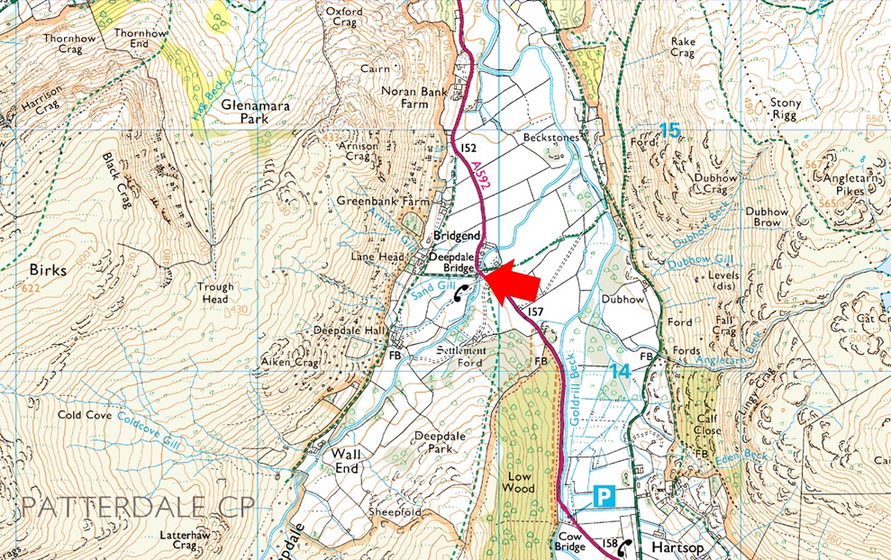
| Route: |
Deepdale Bridge - Deepdale Hall - Wall End - Deepdale - Deepdale Beck - Mossydale - Cawk Cove - Cofa Pike - Fairfield - Link Hause - Hart Crag - Hartsop above How - Gale Crag - Deepdale Bridge |
|
| |
|
Parking Details and Map |
|
|
| Nearest Post Code: |
CA11 0NS |
| Grid Reference: |
NY 399 414 |
| Notes: |
There are limited parking spaces at Deepdale Bridge with spaces for around half a dozen well parked cars. Due to the popularity of the fells around the Deepdale Valley parking here can be difficult after mid morning, my advice is to arrive early and you shouldn't have any trouble parking. Parking is free. |
|
| |
|
Map and Photo Gallery |
|
|
 |
| |
| |
 |
| Views towards Hartsop Dodd, Caudale Moor, Red Screes and High Hartsop Dodd from Deepdale Bridge 6:50am 12°C |
David wasn't supposed to be joining me today after the Dartmoor walk had fallen through; he planned to walk with Jennifer, which also fell through at the last minute. I'd received an email asking if I was walking and if he could tag along. I replied, explaining my route briefly and my arrival time, and heard nothing back. It was 6:40am when I arrived, slowing down to reverse my car against the wall, when David's car appeared. Bloody great timing. Before we'd even touched on the subject of today's walk, we both expressed our frustration at having to cancel the Dartmoor walk for the third time; admittedly, we had more notice for the first two, which is why we were so down and out about it. I suppose if one good thing came out of not travelling to Dartmoor was at least we had time to change our plans, I couldn't imagine how miffed we'd been after driving for five hours then having to put the tent up while it was lashing it down.
The air was cooler as of late, and without question I added a softshell jacket while David slid his Paramor windproof smock on; shorts are mandatory at this time of year. Other than Deepdale Beck murmering below, it was a quiet start to the morning, with only the odd car passing as we completed our kit up. We left the parking spaces before heading up the narrow lane towards Lane End Farm, where a luxurious new build had been completed, which I remembered being under construction in September last year. To say we were impressed would have been an understatement, but we can dream I suppose. From the new build, we turned left, passed through a gate, and followed the track towards Deepdale Hall. |
 |
| Deepdale Hall circa 1670 |
| After numerous visits through Deepdale today was the first time I stopped to view Deepdale Hall both agreeing that it looked either sixteenth or seventeenth century, a good guess as I later found out. |
 |
| Views into Deepdale towards Erne Nest Crag, Hart Crag, Link Hause, Fairfield and Greenhow End. |
| We left Deepdale Hall behind and entered the valley proper from where we took in the impressive views towards Greenhow End and Link Cove. Deepdale and indeed the Dovedale valley are as impressive to me as the Wasdale or Ennerdale valleys. |
 |
| Erne Nest Crag, Link Cove and Greenhow End from Deepdale Beck. |
| The forecast was for sunny spells but through a mix of haze and high level cloud we were yet to see any sunshine. That's Fairfield over on the right whose summit has been below cloud for the time we've been walking through the valley. |
 |
| Looking back through Deepdale with Gale Crag and the Hartsop above How ridge over on the right. |
| The path forks left for Link Cove or right for Deepdale Hause which up until now, was still our intended route of ascent. Not seen in the photo are the three tents we passed where Deepdale Beck snakes through the valley close to the moraines like a giant letter 'S' A great place for a wild camp we both agreed, must have been a very wet night though. |
 |
| Greenhow End, Hutaple Crag, Black Tippet and Cofa Pike come into view. |
| We leave Deepdale behind and entered the micro valley of Mossydale before the narrow path climbs up alongside the now ravined Deepdale Beck. |
 |
| Amazing rock scenery as we continue our ascent into Cawk Cove. |
Aside having a moan about this summers weather it was during this ascent we decided to put the world to rights generated after I'd told David about my recent Audible book purchase 'Nuclear War' I don't get the time to read and as I'm in the car more than I'm at home which has allowed me to build a collection of over 180 Audible titles mostly about Mountaineering or British Military operations around the world which I'm also very interested in.
After reading the reviews on Nuclear War I thought 'nah not for me' but no matter how gruesome its words are I can't switch it off. It's the kind of listen that reminds of me what my Mum used to say; 'if David put his hand in the fire would you do the same" I would and I can't stop burning my hand at the minute listening to a real time scenario of a nuclear attack on the east coast of America. |
 |
| Cofa Pike (ahead) and Sleet Cove (right) from the Sheepfold, Cawk Cove. |
| It was David who first suggested we try a direct ascent on Fairfield via an area of Fairfield's north face known as Flinty Grave, my ears pricked up when I heard David's suggestion replying enthusiasticly "I'm up for it" |
 |
| Our line of ascent. |
By now the sun had briefly come out, and we were basking in warm sunshine tempered by cool mountain air. From the Sheepfold, we still had the option to head right for Deepdale Hause, but we decided to ascend around 500 feet of steep grassy tongue and evaluate an ascent via Flinty Grave from its top. After crossing the origins of Deepdale Beck after the Sheepfold, we began the steep ascent of the tongue, each forward step, feeling like we were wading in and out of deep snow, such the boggy grass underfoot which absorbed water like a sponge.
It was hard work to reach the top of the tongue from where we made our decision. The option to ascend via Flinty Grave looked as advertising as its name sake suggests, the area being made up of steep loose scree. During our ascent of the tongue, we were weighing up other possible ascents. I spotted two shelf routes on Cofa Pike, but on closer inspection, these were buttressed by steep rock. David suggested gaining the col linking Fairfield with Cofa Pike, a narrow ridge around 250 feet in length. After agreeing an ascent by eye, we went for it. |
 |
| Cloud pours into Cawk Cove. |
| Minutes after making the decision to ascend the col cloud began to pour into the cove and although we never spoke of it I'm sure it was on David's mind as it was mine, that we'd made the right route choice. |
 |
| The only way is up. |
| We spent a few more minutes deciding which side of the scree we were going to ascend by. 50 feet lower both options looked credible. Two threes and three twos both arrive at six. We opted left as it was the side that naturally ascends towards the head of the col. |
 |
| Watching the cloud dramatics from our ascent. |
| The cloud thickened and continued to pour into the cove until it stretched across the entire width of Deepdale. With the cloud came drizzle. Non of us expecting either! |
 |
| I have some catching up to do. |
| With around 100 feet to go the valley wall steepened to the extent our walking poles were well above our heads. I needed to pee but the ground was too steep to stop and damp in the rain. I spotted a flat spot and after a quick pee I turned around to see David ascending while clutching at grass, Jesus I muttered "Can't wait Paul I don't want to lose momentum" David shouted back. |
 |
| Cofa Pike summit. |
| Feeling much lighter I traced David's ascent; I too clutching at the wet grass and ringing the sods out in the process. |
 |
| Fairfield summit. |
Cofa Pike felt as eerie as it looked from where we spent a few moments looking down into the mist at the shelf routes and rock walls I'd spotted earlier. We both agreed that even in perfect conditions, we'd have been asking for trouble. We retraced our steps back to the col, opting for different descents before linking up with the summit path Fairfield bound. Although we never said it I'm sure we both agreed that it was nice to have firm footings underfoot again. By now Cofa Pike was disappearing in the mist, as was the col we'd ascended by. "There's life in the old dog yet," David joked. At nine years my senior David practically ran that last 50 feet of ascent. "Aye, I nodded."
We shouldered Fairfield as the mist clung to layers, hair included. Through the cloud, we heard voices and then silence until we spotted two fell runners topping out on Cofa Pike. The outlines of their bodies barely visible as we continued over the shoulder, sighting the familiar cairns that led us towards the summit shelter. The wind had dropped but there was no let-up with the mist, which had turned into rain. We continued towards Link Hause, passing the head of the gully we so nearly ascended by. From out of the cloud, a chap and a black labrador appeared, one hand glued to his phone and the other holding the pooches lead. He veered sharply towards us without summiting and passed with a 'morning' shortly followed by the two fell runners we'd seen on Cofa Pike minutes earlier. |
 |
| Hart Crag summit. |
| The mist and cloud was relentless as we crossed Link Hause, visibility down to the end of our toe caps while others just the outline of rock in the near distance. Cold now, my fingers & hands crying out for a pair of gloves which I obliged them by. Our path began to descend both of us never fearing our position as we left Link Hause behind for the short but steady ascent on Hart Crag. Over to our right the secondary summit cairn; in conditions as we had could have easily been mistaken for the main summit which we knew was just a few feet away to the south, sure enough after rock hopping between the two cairns the summit appeared. |
 |
| Leaving Hart Crag for Hartsop above How. |
| We track east and pick up the path which will descend us steeply from the summit both hoping that we'd also drop out of the cloud. |
 |
| Hartsop above How from the descent of Hart Crag. |
| Sure enough we descended from the cloud first sighting three tents below Dove Crag who had pitched up right at the side of the path. This was the third time we'd seen such a thing in as many weeks and we still couldn't understand why folk would pitch up at the side, or on top of a path frequently used by walkers. |
 |
| Cloud lingering above Hart Crag and Fairfield. |
| By now we were starting to pass walkers all heading towards Hart Crag summit with the exception of a trio who passed across the head of Houndshope Cove towards Dove Crag, their route looked like hard work and we gave every credit to them. |
 |
| Looking back on Hart Crag, Fairfield, The Step and Greenhow End. |
| Although the cloud was beginning to lift we were still waiting for the promised sunshine to develop. Not long from Hartsop above How summit now. |
 |
| Views over Erne Nest Crag towards The Step, Greenhow End and Deepdale Hause. |
| It's impossible to see the path that climbs up from Mossydale into Cowk Cove via the ravined Deepdale Beck in the distance. |
 |
| Classic Hartsop above How views. |
| |
 |
| Place Fell, Boredale Hause and Angletarn Pikes from Gale Crag. |
Hartsop above How soon came from where we took in the views into Dovedale below, remembering last year when we summited Dove Crag before going onto explore Stand Crags with Rod and his daughter Louise. Continuing down the ridge we are passed by dozens of walkers all heading towards Hartsop above How and beyond. The sun eventually came out, bringing with it instant heat, causing David to de-layer to his t-shirt, 'I'll put up with the heat," as we we're close to the cars but in reality, we still have half an hour of walking to do yet. The heat increases, and I'm sure I'm getting funny looks from the folk we pass who'd set off in shorts and t-shirts. We spot the new build over the Deepdale valley and dream some more, agreeing on its near-perfect location. I start to complain that I'm overheating again. David laughs it off.
The path leads us through woodland; tree routes and pine needles are the perfect combination for a slip, and I'm still boiling over. I joke for David to release the pressure valve so my body heat can escape. The sound of traffic travelling along the A592 below brings me back to civilization, which at one point backs up over Deepdale Bridge but begins to flow again as we cross the field where I spotted our cars next to the bright red telephone box. Taking care not to get nettled, we cross the stepped wall and walk the twenty feet back to our cars as I de-shoulder while at the same time bringing my front zip down. Pack and soft shell come away as one as I kick my feet into the backs of my boots, the shift felt heavenly. The feeling of frustration of not being able to get to Dartmoor was real, we broke bread through Deepdale discussing how gutted we felt but you know what, I'd forgotten all about Dartmoor deep within the crags and coves of Fairfield. |
|
| |
| Back to top |
 |
|