Nantlle Ridge Circuit

3rd April 2025


Overview
Ascent: 2,781 Feet - 847 Metres
Summits: 4, Y Garn - Mynydd Drws-y-coed - Trum y Ddysgl - Mynydd Tal-y-mignedd
Weather: Bright & Sunny. Strong Gust Where Exposed. Highs of 17°C Lows of 6°C Feels Like -2°C
Parking: Rhyd du Station, Caernarfon
Area: Eryri National Park (Snowdonia)
Miles: 7
Walking With: On My Own
Ordnance Survey: OL17
Time Taken: 4 Hours 30 Minutes
Route: Rhyd-Ddu Station - Afon Gwyrfai - Drwsycoed Uchaf - Y Garn - Mynydd Drws-y-coed - Trum y Ddysgl - Mynydd Tal-y-mignedd - Bwlch-y-Ddwy-elor - Rhyd-Ddu Station
 

Parking Details and Map
Nearest Post Code: LL54 6TL
Grid Reference: SH 570 525


Map and Photo Gallery


Mynydd Mawr from Rhyd Ddu Station Car Park 07:30am 6°C

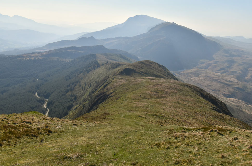
It's been an incredible start to Spring as we look forward to a fourth week of prolonged sunshine but don't be fooled by all the brightness it's still well below freezing on the highest peaks adding to this is an easterly wind that's brought the temperatures down making it feel much cooler than it actually is. The Nanttle Ridge Circuit has been on my radar for quite sometime and with the run of great weather I couldn't think of a more perfect time to head to Snowdonia so I can draw a line through this sought after walk. The Nanttle Ridge spans Rhyd Ddu to Nebo (Near Llyn Cwm Dulyn) covering 9 miles over seven summits between 600-800 metres which although not technical, offers that edgy feeling throughout. To traverse the full ridge would require two cars, public transport or a very long walk back to the start point, however, the route can be compressed into this circuit summiting four of the seven peaks while still having that ridge feel to the walk, this walk had my name written all over it. With the run of good weather I booked a day off work and and as usual did as much research into the route as I could, as mentioned the route isn't technical with the exception of a Grade One scramble to gain the second summit of Mynydd Drws-y-coed which can be airy although the full extent of the scramble can be avoided but I would urge the walker to ascend the spine as I did. As usual I had pre-walk nerves blending into excitement the evening before in anticipation of getting up onto the ridge, I'm sure if I could of missed out on a nights sleep and somehow been tele-ported to the car park at Rhyd Ddu I would have.

It was still dark when I left home with dawn rising as I drove through Colwyn Bay the light of the morning growing stronger with each minute passed. By the time I had driven through the quaint villages of Waunfawr and Betws Garmon I was looking at the Snowdon foothills all blessed in golden morning light. By 07:30am I'd arrived at Rhyd Ddu Station Car Park (Welsh Highland Railway) finding just one other car parked up I set about getting my kit together. The first thing I noticed the moment I opened the car door was how gusty it was, not just windy but gusty enough to rearrange my gear including one of my Montane gloves which left the boot of its own accord only spotting it as it tumbled across the empty car park, flipping eck I thow't (I may have used stronger language) As the wind swirled around my ears I continued my kit up my heart sinking a notch as I faced the realistic fact I might not be able to complete the round. I left the car to empty six pound coins into the ticket machine but the machine didn't want to accept the coins trying each one separately I did everything bar bite the bloody things. I returned to my car to get my wallet and I was able to use chip and pin, thank god for that. Fifteen minutes had passed trying to sort out payment - I put it to the back of my mind as just a minor set back.


Y Garn and Mynydd Drws-y-coed from the ornate gate opposite the Station Car Park.
With the car locked I crossed a deserted A4085 and passed through the ornate gate, its pull handle formed in the shape of a shepherds crook, nice touch that. From the gate I walk the gravel path before crossing Afron (River) Gwyrfai by what looked like a new footbridge before the path swerves right within spitting distance of the Outdoor Centre (white buildings seen right) Whether the wind had died down I wasn't sure but It was no longer on my mind, my main objective overtaking Summit Y Garn.

Sun rising over the Alt Maenderyn ridge (left) and Yr Aran (right)
The car park clearly visible below! What a cracking sunrise though.

Moel Hebog, Moel yr Ogof and Moel Lefn seen as I cross the Afon (river) Gwyrfai
With Llyn y Gadar seen in the foreground.

Y Garn ahead.
After crossing the footbridge the path parallels against a farm track where a farm worker stopped to close a gate before returning to her pickup smiling through sunglasses as she passed. I returned the gesture before passing through the final gate opposite Rhyd Ddu Outdoor Centre onto a second track which would lead me to the base of Y Garn.

Views over Llyn y Dywarchen (Reservoir)
 

Y Garn summit shoulder.
I broke the ascent into two predominantly where the steepness of the climb gave way for two grassy plateaus before the summit crags came into view along with a lone hawthorn that swayed in the summit winds. Grass eventually gave way for boulder as I strode towards the summit wall ahead.

Mynydd Drws-y-coed and Trum y Ddysgl from the summit wall.
Boulder gave way for the summit wall and this incredible view of Mynydd Drws-y-coed and Trum y Ddysgl. Todays final summit of Mynydd Tal-y-mignedd can be seen to the lower right with Garnedd-goch, the fith of seven summits (if completing the full ridge) in the distance.

Mynydd Mawr and Moel Eilio from Y Garn summit.
With the carin reached I walked over to the summit edge to take in this fantastic view of Mynydd Mawr. Standing lone Mynydd Mawr is the northern outlier of the Moel Hebog group.

Mynydd Drws-y-coed and Trum y Ddysgl from Y Garn.
I reluctantly left Y Garn as nerves began to build in anticipation of the scramble up Mynydd Drws-y-coed ahead. With the clearest of views I began to 'eye' my route up the ridge the strong winds however, were starting to take over thought process.

Views towards Mynydd Drws-y-coed and Trum y Ddysgl.
I approach to the right of the wall noting that if the scramble isn't to every ones taste the walker can stray left and ascend the steep grassy ridge all the way to Mynydd Drws-y-coed summit.

I begin the scramble on Mynydd Drws-y-coed.
The approach to the base of the scramble led me over boulder and at times, precariously close to the edge of the ridge before winding its way back into boulder. I keep as central as possible to the spine of the ridge comparing it at times to that of Hall's Fell Ridge on Blencathra only more rockier.

Almost at the top as I take in the views over Y Garn.
I had learned through my research that most people thought the scramble was over too quickly and I could only agree. With the adrenalin still pumping I had reached the top stopping twice where hands on contact was required to lever myself over crag and boulder, other than that it was a thoroughly enjoyable scramble.

Rock pinnacle Mynydd Drws-y-coed summit.
For those with a death wish you can follow a narrow path that passes between the summit rocks and the rock pinnacle. given that it's blowing a gale and, that's a little too much exposure for my liking, I keep left.

Mynydd Drws-y-coed and Trum y Ddysgl.
From the rock pinnacle the summits of Mynydd Drws-y-coed and Trum y Ddysgl come into view...yes I know I thought the top of the rock slab and pinnacle was the summit too.

Trum y Ddysgl from Mynydd Drws-y-coed summit.
Forgive me for referring to the Lakeland fells again but this view of Trum y Ddysgl really reminded me of Hopegill Head minus Ladyside Pike of course.

Ridge route to Trum y Ddysgl.
Nerves had settled now that I had the scramble behind me and this wonderful ridge to gain Trum y Ddysgl.

Trum y Ddysgl.
There was a narrow path that follows the ridge line to get that full ridge experience but it was far too windy to get so close to the edge.

Looking back on Mynydd Drws-y-coed summit.
With Y Garn seen beyond.

The view back along the ridge...
...towards Mynydd Drws-y-coed and Y Garn.

Hazy views South towards Moel Lefn, Moel yr Ogof and Moel Hebog.
The ridge to the right is my descent route into the Beddgelert Forest below from where I will follow a forestry track back to Rhyd Ddu via Llyn y Gader (tarn)

Views over Mynydd Drws-y-coed and Trum y Ddysgl towards Snowdon.
After reaching Trum y Ddysgl summit I strode across this lovely grassy connecting ridge towards my final summit.

Mynydd Tal-y-mignedd (right) and Garnedd-goch (left)
I won't be travelling as far as Garnedd-goch instead after summiting Mynydd Tal-y-mignedd I will double back, that means traversing the wonderful narrow band of ridge below twice.

Mynydd Tal-y-mignedd.
Not seen in the photo but there's a mini scramble to be negotiated along the first section of the ridge.

Mynydd Tal-y-mignedd and Garnedd-goch.
The wind was beginning to build more so over exposed ridges. MWIS had forecasted 'strong sudden gust with no warning' MWIS got the first part correct as keeping balance was becoming a struggle however at least I could hear the gust before they arrived giving me a few seconds warning to dig my walking poles into the ground and hold on until they passed.

Mynydd Tal-y-mignedd summit obelisk.
Despite the winds crossing the ridge was an absolute pleasure finding shelter where the ridge narrowed over scramble it was surreal to hear the wind over my head but be completely unaffected by it. I emerged back onto the ridge finding the sudden gust affecting the south western corner of the ridge where the wind funnelled up from the valley picking up debris along its way including grass and heather. Between the sudden gust I arrived at the summit wall and passed through a gate which rattled in the wind. I estimated the wind to be in the region of 50mph plus.

Garnedd-goch from Mynydd Tal-y-mignedd.
It would have been nice to stop for a quick bite to eat but it was getting exhausting trying to keep upright confirmed during a null in the wind when I heard my panted breath while stood at the summit.

But at least I get to enjoy this fantastic view.
During my descent it had occurred to me that I might not have to re-ascend Trum y Ddysgl instead hoping that there might be a traverse path to the right at the end of the ridge. There was indeed a path but it looked harder work passing over all those rocky spines than it did to make the re-ascent.

The only walker I'd seen all morning.
I passed this retired Policeman who lived at the foot of Snowdon in Llanberis who as it turned out had relatives in Wigan and has frequented many of the pubs that I used to drink in. I warned the chap about the winds along the exposed areas of the ridge.

Making my descent with views of Moel Hebog.
The sun still shone brightly into a cloudless sky and it was during this descent that I would experience winds equal to those that battered me on the Trum y Ddysgl ridge.

Views of Snowdon as I enter the Beddgelert Forest.

I thought the worst of the winds were behind me more so as I began my descent towards the Beddgelert Forest where the strongest gusts funnelled over the ridge, taking away all thought process my ears screamed and my eyes and nose poured relentlessly until I reached the shelter of the forest where you could drop a feather and watch it float to the ground, again it was surreal as I stopped to soak in the silence and soon I began to overheat. Before continuing I removed my jacket, rolled up the sleeves of my base layer and began the walk through the forest which the retired Policeman told me "you'll enjoy it through there" It was difficult to tell for how long windblown trees had blocked the track - some I could get around by ducking under or striding over the tree trunks but others blocked the track for up to a hundred yards at a time meaning finding an alterative route over felled plantation which for anyone who has had to do this will know how slow, and unpleasant it can be.

Keeping the forestry track to my left its gravel base coming in and out of view as I stepped over broken tree trunks and broken branches my legs often disappearing between branches up to the knee, not only was it hard work I was in fear I was going to break something. I rejoined the track at a crossroads as I looked back at what can only be described as a bomb cratered forest, I guessed the retired Policeman hasn't been down here for a while. I collected myself as the wider track allowed the sunshine to pour through the breaks in the forest canopy, it was hot and I was relishing the warmth the approaching midday sun provided. I was still a mile away from Rydu Ddu as I continued to follow the track Snowdon popping in and out of my view above the treeline until my view changed to one I didn't recognise. Damn! I had missed my turning realising I should have turned left at the narrow track I'd passed a minute earlier. It was no bother just a hundred yards or so back track. I found the path and turned right from where Llyn Y Gader came into view the path below my feet flanking Drwsycoed Uchaf and eventually Y Garn. The path was sheltered, dusty and hot and for the first time this morning I could hear the lambs in the nearby fields whilst a gentle breeze broke the surface of Llyn Y Gader as it shimmered in the sunlight below.


Back to top