|
Mardale Head to Cawdale |
 |
 |
21st June 2025 |
 |
|
|
| |
|
Overview |
|
|
| Ascent: |
2,708 Feet - 825 Metres |
| Wainwrights: |
6, High Street - The Knott - Rampsgill Head - Kidsty Pike - High Raise (Martindale) - Wether Hill |
| Visiting: |
4, Rough Crag - Red Crag - High Kop - Low Kop |
| Weather: |
Sunny Intervals Breezy at Height, Showers Later. Highs of 20°C Lows of 19°C |
| Parking Using x2 Cars: |
Car Park Mardale Head - Roadside Parking Moorihill Farm,Cawdale |
| Area: |
Far Eastern |
| Miles: |
11 |
| Walking With: |
David Hall |
| Ordnance Survey: |
OL5 |
| Time Taken: |
6 Hours |
| Route: |
Mardale Head - The Rigg - Rough Crag - Caspel Gate - Long Stile - High Street - Straights of Riggindale - The Knott - Rampsgill Head - High Raise (Martindale) Raven Howe - Red Crag - Wether Hill - High Kop - Low Kop - The Hause - Hause End - Cawdale |
|
| |
|
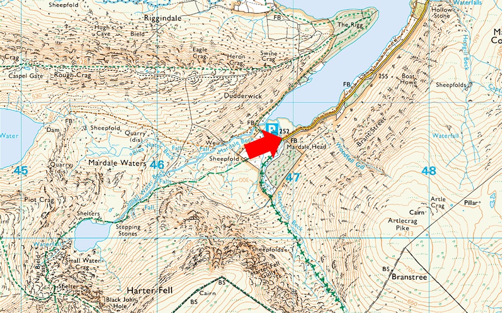
Parking Details and Map |
|
|
| Nearest Post Code: |
CA10 2QT |
| Grid Reference: |
NY 469 310 |
| Notes: |
Probably one of the most scenic car parks in Lakeland found at the head of the Mardale Valley offering easy access onto the High Street fells plus many more. The car park during Summer can fill up quickly but with most car parks in Lakeland if you time your arrival early enough you're always guaranteed a parking place. Parking is free. |
|
| |
|
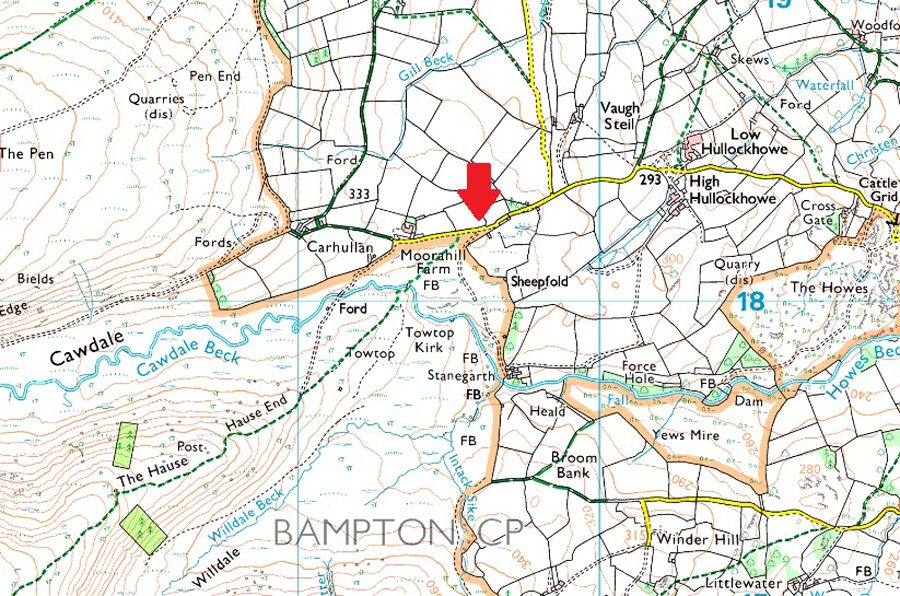
Parking Details and Map for Limited Parking Spaces, Moorahill Farm Cawdale |
|
|
| Nearest Post Code: |
CA10 2QL |
| Grid Reference: |
NY 493 182 |
| Notes: |
There is limited parking at Moorahill Farm. Opposite the farm is a small patch of land which appears as limited off road parking, however the farmer has used this land to stock pile gravel possibly because of inconsiderate drivers who would block the farmyard entrance opposite. During my visit I parked approximately sixty yards further down the road on a large patch of grass, it hadn't rained for days and the grass was dry although there was evidence of cattle hoofs which leads me to believe I may have been wrongly parked. My advice is to ask if unsure. |
|
| |
|
Map and Photo Gallery |
|
|
  |
| |
| |
 |
| Harter Fell (Mardale) from Mardale Head 7:05am 19°C |
It had been an incredibly hot and humid week but I was still looking forward to walking Pen and The Scafells from Eskdale, a walk that I had to put off at the beginning of June to a poor forecast. As the week progressed I began to have second thoughts, maybe I was taking too much on in that temperatures were reaching the high twenties. A couple of years back I climbed Cam Spout Crag in similar heat and was caught out by heat stroke during my ascent, feeling nauseous coupled with the cold sweats and the shivers I persevered; but to fall ill so far out was a tad nerve racking, anyway I ended up looking for different options surrounding my favourite fell, High Street.
David had emailed me on Thursday evening asking me a question about his new car and in the same email the subject changed to where we'd be walking the coming weekend. David had climbed Helvellyn that afternoon (Thursday) and explained how the heat and humidity made the walk twice has hard adding he wouldn't be going out on Friday as planned. I explained I was looking at walking High Street from Moorahilll Farm in Cawdale which was when David chirped in "that would make a great two car walk" With Rod and Michael walking a rather epic route up onto Seat Sandal, down the south ridge before ascending Helm Crag for a complete round of Greenburn David and I concreted our plan and had arranged to meet at Cawdale at 6:45am.
I arrived early around 6:30am after a witnessing a beautiful sunrise to find David already parked up, he was even facing the right way for the return journey later. After a quick swap of gear from my car to David's we left Cawdale, drove through Bampton before heading south to Mardale Head arriving about twenty five minutes later where we managed to grab the last parking space sparking the words "7:00am starts are the new 8:00am starts of old" It was a lovely mild morning with just a hint of a breeze to keep the rising temperature at bay. More cars began to arrive each struggling to park as I performed a sweep of the boot making sure I'd packed my waterproof jacket as rain was forecast for early afternoon, with any luck we'd be in Cawdale by then. Wearing just shorts and a T-shirt and with laden packs, we passed through the deer gate and began our walk towards The Rigg. |
 |
| Low water levels, Haweswater Reservoir. |
| Cumbria is officially in a state of drought with low water levels across the counties reservoirs including Hawsewater and Thirlmere. The water level has been low for so long grass has started to grow with walls and ruined buildings from Mardale of old appearing, for me, the grass growing takes you back to how perhaps Mardale would have looked like before the times of the rservoir. |
 |
| Looking into the Riggindale Valley with Kidsty Pike seen centre and Kidsty Howes seen right. |
| We climbed up towards The Rigg then turned left towards Swine Crag passing this prime spot for a great view into the Riggindale Valley. |
 |
| Looking down on Haweswater Reservoir and The Rigg. |
| With the sun on our backs we got stuck in to the ascent of Swine Crag stopping to take in the view back down on The Rigg where beyond, the sun shimmered into a glistening Haweswater. |
 |
| Views over Mardale Waters towards Harter Fell (Mardale) Small Water, the top of Nan Bield Pass and Piot Crag. |
| Any worries about over heating, or indeed heat stroke were laid to rest once height was gained where the breeze had strengthened which helped to contain the humidity further, happy days. |
 |
| Long Stile, High Street, Short Stile and Two Penny Crag from Rough Crag summit. |
| Despite the full car park we were yet to see another walker, that was until we spotted a solo chap descending towards Blea Tarn from Long Stile. |
 |
| Mardale III Bell and Blea Water from Rough Crag. |
| Time to head down to Caspel Gate now. |
 |
| Riggindale Crag, Long Stile, Short Stile and Two Penny Crag from Caspel Gate Tarn. |
| From Rough Crag we followed a familiar trod towards Caspel Gate wondering whether the tarn might have dried up, we soon got our answer. Despite the tarn being full it was unusually dry around the circumference of the tarn. Now would be a great time to wild camp the area I thought. |
 |
| Looking down on Riggindale Crag and the Rough Crag ridge from our ascent on Long Stile. |
| While distant views were beginning to get lost in a thickening haze. |
 |
| High Street summit trig point. |
We made good time ascending Long Stile taking the ascent in our stride until we reached stone cairn at the top. The heat was stifling, oddly the wind had weakened at summit height and we found ourselves walking into pockets of heat as if we'd 'just opened the oven door'
From the direction of Thornthwaite Crag a fell runner appeared and we stopped to chat for a good ten minutes, turns out he was from Workington and was reckying what he said was 'The 50' which we guessed was the Montane 50K fell run. He'd set off from Kentmere and was heading back via Mardale III Bell, Harter Fell and Kentmere Pike, a really likeable fella who we could level with. Top chap, didn't get his name though. |
 |
| Through the haze, we took in the view towards the Eastern fells. |
| It appeared the sun was climbing into high cloud, some of it dark and brooding, once clear it was hot and humid again. |
 |
| Descending towards The Straights of Riggindale with views of The Knott, Rampsgill Head and Kidsty Pike. |
| We were soon caught up by two more fell runners who stopped on the shoulder of High Street to release a drone which in turn would record them descending the fell. But instead of waiting until both David and I were clear they released the drone which totally destroyed the ambience. I don't mind drones but if your going to use them, at least wait until other folk are clear. |
 |
| Looking back on High Street from The Straights of Riggindale. |
| |
 |
| Rampsgill Head and High Raise (Martindale) from The Knott summit. |
| The sun continued to shine but more in the way of patches as more high cloud arrived. By the time we'd crossed The Straights of Riggindale it was noted that the wind was increasing in strength, probably in anticipation of the rain which was due in a couple of hours time. Just two more short ascents now before we get to enjoy the grassy ridge linking High Raise with Wether Hill. |
 |
| Looking back on The Knott. |
| |
 |
| High Raise (Martindale) Wether Hill, Gowk Hill and Steel Knotts from Rampsgill Head summit. |
| Time to pay a quick visit to Kidsty Pike. |
 |
| Mardale III Bell, Long Stile and High Street from Kidsty Pike summit. |
We followed a familiar grassy trod before linking back up with the main path just below Kidsty Pike summit where we spotted a chap lying down looking at his phone, the wind didn't seem to bother him as we passed with a 'morning' before reaching the summit rocks from where we took in the view into the Riggindale Valley below.
It was David who first spotted half a dozen Deer on the slopes below the summit when we were joined by a young girl who came over to see what we were looking at. By this time more Deer were starting to appear arround the dammed corrie below the summit. While it was blowing a gale up here it looked nice and peaceful down at valley level. |
 |
| Leaving Kidsty Pike for High Raise (Martindale) |
| We left the young girl still looking at the Deer and began the short, but delightful ascent on High Raise. |
 |
| Wether Hill and Loadpot Hill from High Raise (Martindale) |
| We were still making good time but were also conscious of the changing conditions, with the increase in wind speed we could see cloud building up towards the south and west, the weather front that we'd been warned about. Adding to this there was also a change in atmospherics, the same charge you would feel just before a thunder storm. Despite these changes we took a quick five minute rest in the summit shelter and scoffed down a couple of slices of Soreen Banana cakes. |
 |
| Hey-ho here we go. |
| Beyond the wall is Red Crag and beyond that, Wether Hill while over to the right is High Kop and Low Kop todays route of descent. |
 |
| Wether Hill and Loadpot Hill from the descent of Red Crag. |
| As I said to David "it's almost like a treat walking across here" The sunshine was breaking yet the humidity was through the roof and we were thankful of the wind, which I swear, continued to strengthen. |
 |
| Views over Ramps Gill towards the general gloom as the fells mould into a thickening haze. |
| I don't think a picture can see the true conditions we were feeling because right about now we were deciding whether it was a distant rumble of thunder or a plane that we could hear approaching. |
 |
| David side stepping High Kop. |
| We traced our way back for a short while before finding a trod which skirted around the head of the Cawdale Valley. We had really been looking forward to walking between High Kop and Low Kop but right now it felt like we were trying to out run an impending thunder storm or at least, a heavy rain shower. We had passed a solo walker carrying a large pack and we wondered if he knew rain was imminent. |
 |
| Heading towards Low Kop (centre) with views of Haweswater Dam. |
| Our route veers left from Low Kop, across the fell top before descending into Cawdale, it's actually a lot further than it looks! |
 |
| Descending into Cawdale via The Hause. |
| |
 |
| The Hause (left) Wether Hill (distant centre) and Loadpot Hill (distant right) |
The rain, and thankfully no thunder eventually reached us tapping at tanned skin while being whipped around by the ever strengthening wind. We still had a good mile and half to go and wondered if we'd make it back to Cawdale before the onslaught arrived. The rain continued to fall but the humidity remained, do we or don't we add our waterproof jackets? Sod it we'll continue a bit further. We could hear the gusts coming from behind and with it, more rain causing us to eventually stop and give in. Out came the jackets flapping in the wind as my arm failed to find the sleeve, I only zipped my jacket a few inches just so my chest could breathe out the humidity, I suspect David, the same.
We reached The Hause and passed between the tree copse as my car came into view. It was still half an hour away and during that time the rain teased us, looking back I should have never added my jacket, I'm sure David felt the same. We reached the valley floor and passed through an open field my car getting closer and closer before crossing Cawdale Beck at a wonderful clapper bridge. From our right we crossed paths with two women who told us they'd been for a swim, or did they mean paddle? not sure, friendly though and we joined the tarmac together both our cars just minutes away now. I looked back at The Hause to find blue skies appearing between the grey, rolling my eyes I turned to David "would you bloody adam and eve it" |
|
| |
| Back to top |
 |
|