Parking Information for - Grasmere Village

Parking Details and Map
Nearest Post Code: Stock Lane LA2 29SJ - Red Bank LA22 9PU - Broadgate LA22 9TA - Grasmere C.E Primary School LA22 9SJ
Grid Reference: Stock Lane NY 339607 - Red Bank NY335 907 - Broadgate NY338 077 - Grasmere C.E Primary School NY 338 807
Notes:

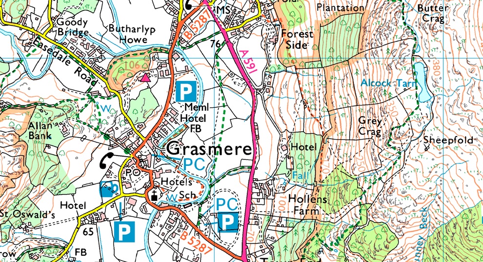
Grasmere is possibly one of Lakelands busiest villages along with Ambleside and during peak seasons parking in the village after noon can be tricky, below are the locations of the four car parks found within the village, local walks from the village include Helm Crag, Easedale Tarn and Alcock Tarn.

Stock Lane car park (LA22 9SJ - NY 339 607) is found on the right as you enter the village just off the B5287, Stock Lane is a Pay and Display car park.

Red Bank Road car park (LA22 9PU - NY 335 907) is a large car park found just outside the village itself, Red Bank is a Pay and Display car park.

Broadgate car park (LA22 9TA - NY 338 077) is found on the outskirts of the village further along the B5287 and has seating which overlooks the River Rothay, Broadgate is a Pay and Display car park.

The final car park doubles as the playground at Grasmere C.E Primary School (LA22 9SJ - NY 338 807) and is only available at weekends and school holidays. The School is found on the right after passing Stock Lane car park right opposite the Mountain Warehouse store, there is a Honesty Box on the School wall.


Walks starting from this parking place

Walking the Wainwrights in 30 Walks - Walk 14 The Langdale Pikes from Grasmere

View this walk

22nd May 2016
ASCENT: 3'440 Feet - 1,092 Meters
MILES: 13
WAINWRIGHTS: 9, Silver How - Blea Rigg - Harrison Stickle - Loft Crag - Pike O'Stickle - Thunacar Knott - Pavey Ark - High Raise (Langdale) - Tarn Crag (Easedale)
ROUTE: Grasmere - Kelbarrow - Silver How - Lang How Tarn - Blea Rigg - Stickle Tarn - Harrison Stickle - Harrison Combe - Loft Crag - Pike O'Stickle - Harrison Combe - Thunacar Knott - Pavey Ark - High Raise (Langdale) - Coledale Head - Lang Crag - Tarn Crag (Easedale) - Easedale Tarn - Sourmilk Gill - Goody Bridge - Easdale Road - Grasmere
 

Silver How, Blea Rigg & Tarn Crag


2nd February 2014
ASCENT: 2,041 Feet, 622 Meters
MILES: 8.1
WAINWRIGHTS: 3, Silver How – Blea Crag – Tarn Crag (Easedale)
ROUTE: Grasmere – Allan Bank – Wray Gill – Silver How – Brigstone Moss – Langhow Tarn – Blea Rigg – Belles Knott – Coledale Tarn – Tarn Crag (Easedale) – Tarn Crag East Ridge – Easedale Tarn – Sourmilk Gill – Easedale Beck – Easedale Road – Grasmere
 

High Raise from Grasmere via Helm Crag

View this walk

7th January 2012
ASCENT: 2,800 Feet, 854 Meters
MILES: 9.6
WAINWRIGHTS: 5, Helm Crag, Gibson Knott, Calf Crag, High Raise, Sergeant Man
ROUTE: Grasmere – Easedale Road – Helm Crag – Gibson Knott – Calf Crag – Brownrigg Moss – Mere Beck – High Raise – Sergeant Man – Easedale Tarn – Easedale – Grasmere
 

Silver How & Tarn Crag (Easedale)

View this walk

19th June 2011
ASCENT: 1,774 Feet, 541 Meters
MILES: 8.1
WAINWRIGHTS:

3, Silver How, Blea Crag & Tarn Crag (Easedale)

ROUTE:  
 

The Greenburn Horseshoe

View this walk

25th August 2010
ASCENT: 2,456 Ft, 758 Mtrs
MILES: 8.5
WAINWRIGHTS: 4, Helm Crag, Gibson Knott, Calf Crag, Steel Fell
ROUTE:  
 

Sergeant Man & High Raise

View this walk

27th February 2010
ASCENT: 762 Mtrs  2500Ft
MILES: 10
WAINWRIGHTS: 3 Blea Rigg, Sergeant Man,High Raise
ROUTE:  
 

Helm Crag

View this walk

27th November 2007
ASCENT: 428Mtrs  1328Ft
MILES: xxx
WAINWRIGHTS: 1 Helm Crag
ROUTE: xxxx


Back to top