|
Parking Information for - Roadside Parking, Sadgill, Longsleddale |
 |
 |
Parking Details and Map |
 |
|
| Nearest Post Code: |
LA8 9BE |
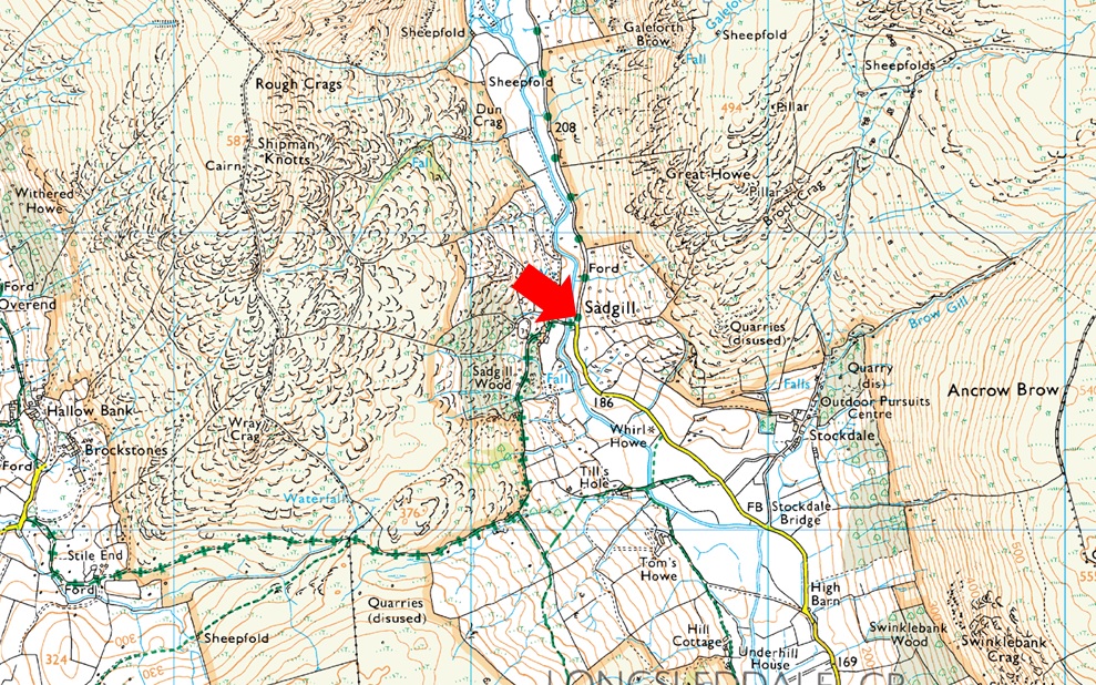
| Grid Refernce: |
NY 483 505 |
| Notes: |
The roadside parking at Sadgill is found deep within the Longsleddale Valley at the end of a long and twisting lane, the only road for six miles that allows access in and out of the valley by car. The lane is narrow with high hedges either side and my advise is when travelling along it be aware of unseen oncoming traffic. The lane ends at Sadgill Bridge below Great Howe and Grey Crag, here you will find parking for up to a ten cars but during Summer it has been known to see cars some way up the valley to the dismay of the local Farmer and his tractor no doubt, my advise is to arrive early, and try to park as neatly as possible, after all Longsleddale is one of those valleys that appears to be untouched by time, Parking is free. |
|
| |
|
Walks starting from this parking place |
|
|
|
Longsleddale, Tarn Crag & Grey Crag |
|
|
 |
|
23rd April 2023 |
| ASCENT: |
2,162 Feet - 659 Metres |
| MILES: |
6.3 |
| WAINWRIGHTS: |
2, Tarn Crag (Longsleddale) - Grey Crag |
| ROUTE: |
Sadgill Bridge - Longsleddale - Brownhowe Bottom - Tarn Crag (Longsleddale) - Greycrag Tarn - Harrop Pike - Grey Crag - Great Howe - Sadgill Bridge |
|
| |
|
Walking the Birketts - Sleddale Fell |
|
|
|
|
30th March 2018 |
| ASCENT: |
2,162 Feet - 659 Metres |
| MILES: |
6.3 |
| BIRKETTS: |
4, Tarn Crag - Harrop Pike - Grey Crag - Great Howe |
| ROUTE: |
Sadgill Bridge - Longsleddale - Brownhowe Bottom - Tarn Crag - Greycrag Tarn - Harrop Pike - Grey Crag - Great Howe - Sadgill Bridge |
|
| |
|
Walking the Wainwrights in 30 Walks - Walk 19 - An extended Longsleddale Circuit |
|
|
|
|
26th June 2016 |
| ASCENT: |
4,495 Feet - 1,371 Meters
|
| MILES: |
14.5 |
| WAINWRIGHTS: |
8, Shipman Knotts - Kentmere Pike - Harter Fell (Mardale) - Mardale III Bell - Branstree - Selside Pike - Grey Crag - Tarn Crag (Longsleddale) |
| ROUTE: |
Sadgill - Longsleddale Pass - Shipman Knotts - Kentmere Pike - Harter Fell (Mardale) - Top of Nan Bield Pass - Mardale III Bell - Top of Nan Bield Pass - Harter Fell - Top of Gatescarth Pass - Branstree - Artle Crag - Selside Pike - Selside Brow - Brownhowe Bottom - Tarn Crag (Longsleddale) - Grey Crag - Great Howe - Sadgill |
|
| |
|
The Harry Griffin 2,000 footers Walk 2 -The Fringe of Lakeland |
|
|
|
|
8th March 2015 |
| ASCENT: |
3,289 Feet - 1,003 Meters |
| MILES: |
9.6 |
| SUMMITS OVER 2,000 Ft: |
Grey Crag (Longsleddale) - Tarn Crag - Branstree - Selside Pike - Adam Seat |
| ROUTE: |
Sadgill - Great Howe - Grey Crag (Longsleddale) - Greycrag Tarn - Tarn Crag - Selside Brow - Branstree - Artle Crag - Selside Pike - Branstree - Gatescarth Pass - Adam Seat - Gatescarth Pass - Sadgill |
|
| |
|
Harter Fell to Shipman Knotts from Sadgill |
|
|
|
|
17th November 2013 |
| ASCENT: |
2,323 Feet, 709 Meters |
| MILES: |
8.7 |
| WAINWRIGHTS: |
3, Harter Fell (Mardale) – Kentmere Pike – Shipman Knotts |
| ROUTE: |
Sadgill, Longsleddale – Harter Fell (Mardale) – Kentmere Pike – Goat Scar – Shipman Knotts – Longsleddale Pass – Sadgill |
|
| |
|
Harter Fell (Mardale) via Wren Gill Quarry |
|
|
|
|
3rd June 2012 |
| ASCENT: |
2, 300 Feet, 702 Metres |
| MILES: |
8.7 |
| WAINWRIGHTS: |
3, Harter Fell (Mardale) Kentmere Pike & Shipman Knotts |
| ROUTE: |
Sadgill, Longsleddale – Wren Gill Quarry – Adam Seat – Harter Fell (Mardale) – Kentmere Pike – Goat Scar – Shipman Knotts – Longsleddale Pass – Sadgill |
|
| |
|
The Remote Far Eastern Fells |
|
|
|
|
29th April 2011 |
| ASCENT: |
1,971 Feet, 601 Meters |
| MILES: |
9.7 |
| WAINWRIGHTS: |
4, Grey Crag (Longsleddale), Tarn Crag (Longsleddale), Branstree & Selside Pike |
| ROUTE: |
|
|
| |
|
| |
| Back to top |
 |
|