|
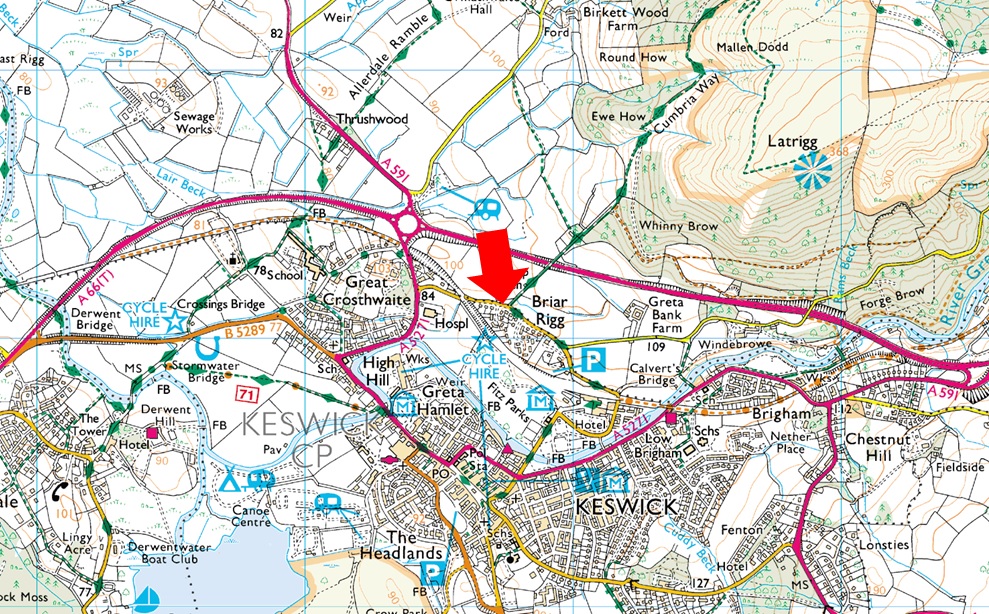
Parking Information for - Roadside Parking, Spooney Green Lane, Keswick |
 |
 |
Parking Details and Map |
 |
|
| Nearest Post Code: |
CA12 4PJ |
| Grid Reference: |
NY 267 324 |
| Notes: |
Spooney Green Lane, Keswick is perfectly positioned for a short walk onto Latrigg, a visit to the old Keswick Railway or even Skiddaw. There is room for up to half a dozen cars but please be considerate when parking as this is a residential street. Parking is free. |
|
| |
|
Walks starting from this parking place |
|
|
|
Skiddaw from Briar Rigg |
|
|
 |
|
6th January 2024 |
| ASCENT: |
3,189 Feet - 972 Metres |
| MILES: |
10.2 |
| WAINWRIGHTS: |
3, Lonscale Fell - Skiddaw Little Man - Skiddaw |
| ROUTE: |
Briar Rigg - Spooney Green Lane - Gale Road Car Park - Hawell Monument - Whit Beck - Lonscale Pike East Top - Lonscale Fell - Jenkin Hill - Lesser Man - Little Man - Skiddaw South Top - Skiddaw - Tourist Path - Gale Road Car Park - Hawell Monument - Spooney Green Lane - Briag Rigg |
|
| |
|
Latrigg, Lonscale Fell & The Threlkeld to Keswick Railway Path |
|
|
|
|
25th June 2022 |
| ASCENT: |
2,350 Feet - 716 Metres |
| MILES: |
12.7 |
| WAINWRIGHTS: |
2, Latrigg - Lonscale Fell |
| ROUTE: |
Brundholme Road - Spooney Green Lane - Cumbrian Way - Mallen Dodd - Latrigg - Hawell Monument - Skiddaw Tourist Path - Lonscale Fell - Lonscale Pike - Burnt Horse - Cumbrian Way - Blencathra Centre - Threlkeld - A66 - Keswick Railway Path - Brundholme Road |
|
| |
|
Walking the Birketts, Skiddaw - The Greater Traverse |
|
|
|
|
11th August 2020 |
| ASCENT: |
3,640 Feet - 1,110 Metres |
| MILES: |
10 |
| BIRKETTS: |
10, Latrigg - Lonscale Pike - Lonscale Fell - Jenkin Hill - Skiddaw Lesser Man - Skiddaw Little Man - Skiddaw South Top - Skiddaw Middle Top - Skiddaw High Man - Carl Side |
| ROUTE: |
Spooney Green Lane - Cumbrian Way - Latrigg - Top of Gale Road - Whit Beck - Lonscale Pike - Lonscale Fell - Jenkin Hill - Skiddaw Lesser Man - Skiddaw Little Man - Skiddaw South Top - Skiddaw Middle Top - Skiddaw High Man - Carl Side - White Stones - Doups - Millbeck - Applethwaite - Birkett Wood - Spooney Green Lane |
-
|
| |
|
Latrigg via the Keswick Railway path |
|
|
|
|
3rd March 2018 |
| ASCENT: |
1,215 Feet – 370 Metres |
| MILES: |
Latrigg |
| WAINWRIGHTS: |
5.5 |
| ROUTE: |
Keswick - Fitz Park – Old Keswick Railway Path - Briery - Low Briery - Brundholme Wood - Latrigg - Mallen Dodd - Cumbrian Way - Keswick |
|
| |
|
Latrigg, High Rigg & Walla Crag from Briar Rigg |
|
|
|
|
4th January 2014 |
| ASCENT: |
3,100 Feet, 945 Meters |
| MILES: |
14.1 |
| WAINWRIGHTS: |
3, Latrigg – High Rigg – Walla Crag |
| ROUTE: |
Briar Rigg – Spooney Green Lane – Ewe How Wood – Mallen Dodd – Latrigg – Brundholme – Railway path – across the A66 – Naddle Beck – Tewet Tarn – Low Rigg – High Rigg – Dale Bottom – Nest Brow – Castlerigg – Rakefoot – Walla Crag – Cat Gill – Derwent Water – Keswick – Briar Rigg |
|
| |
|
| |
| Back to top |
 |
|