|
Parking Information for - Roadside Parking, Top of Dunmail Raise |
 |
 |
Parking Details and Map |
 |
|
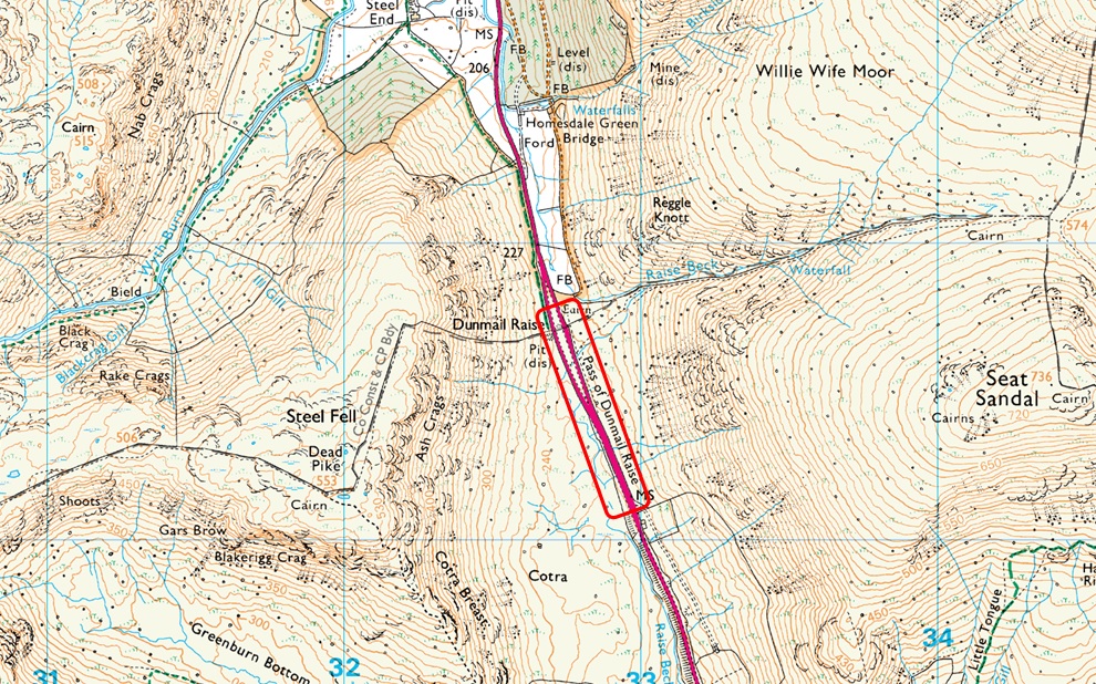
| Nearest Post Code: |
LA22 9RS |
| Grid Reference: |
NY 327 211 |
| Notes: |
The A591 splits into two carriageway's across the top of Dunmail Raise where roadside parking can be found on both sides of the carriageway. However parking is more limited on the left (if travelling from Grasmere) than the roadside parking found on the right, The top of Dunmail Raise offers excellent access onto the Helvellyn and Wythburn Fells which means that despite the ample parking spaces can fill up quite quickly especially during the Summer months. Parking is free. |
|
| |
|
Walks starting from this parking place |
|
|
|
Kirkstone Pass to Dunmail Raise |
|
|
 |
|
5th April 2025 |
| ASCENT: |
3,052 Feet - 930 Metres |
| MILES: |
7.5 |
| WAINWRIGHTS: |
6, Red Screes - Little Hart Crag - Dove Crag - Hart Crag - Fairfield - Seat Sandal |
| ROUTE: |
Top of Kirkstone Pass - Red Screes - Top of Scandale Pass - Little Hart Crag - Bakestones Moss - Dove Crag - Hart Crag - Link Hause - Fairfield - Grisedale Hause - Seat Sandal - Raise Beck - Dunmail Raise |
|
| |
|
Helvellyn to Dollywagon Pike from Swirls |
|
|
|
|
4th January 2020 |
| ASCENT: |
3,050 Feet - 930 Metres |
| MILES: |
6.8 |
| WAINWRIGHTS: |
3, Helvellyn - Nethermost Pike - Dollywagon Pike |
| ROUTE: |
Swirls - Browncove Crags - Helvellyn - Nethermost Pike - High Crag - Dollywagon Pike - Grisedale Tarn - Grisedale Hause - Raise Beck - Top of Dunmail Raise |
|
| |
|
Helvellyn to Dollywagon Pike from Swirls |
|
|
|
|
9th December 2017 |
| ASCENT: |
3,080 Feet - 940 Metres |
| MILES: |
6.8 |
| WAINWRIGHTS: |
3, Helvellyn - Nethermost Pike - Dollywagon Pike |
| ROUTE: |
Swirls - Browncove Crags - Helvellyn Lower Man - Helvellyn - Nethermost Pike - High Crag - Dollywagon Pike - Grisedale Tarn - Grisedale Hause - Raise Beck - Top of Dunmail Raise |
|
| |
|
Helvellyn to Stone Arthur |
|
|
|
|
3rd December 2016 |
| ASCENT: |
3,913 Feet - 1,192 Meters |
| MILES: |
8.5 |
| WAINWRIGHTS: |
6, Helvellyn - Nethermost Pike - Dollywagon Pike - Fairfield - Great Rigg - Stone Arthur |
| ROUTE: |
Swirls - Browncove Crags - Helvellyn - Nethermost Pike - High Crag - Dollywagon Pike - Grisedale Tarn - Grisedale Hause - Fairfield - Great Rigg - Stone Arthur- Greenhead Gill - Michael's Nook - A591 |
|
| |
|
Into the great wide open, Fairfield from Dunmail Raise |
|
|
|
|
30th October 2016 |
| ASCENT: |
3,404 - 1,038 Meters |
| MILES: |
8.2 |
| WAINWRIGHTS: |
4, Seat Sandal - Fairfield - Great Rigg - Stone Arthur |
| ROUTE: |
Dunmail Raise - Seat Sandal - Grisdale Tarn - Grisdale Hause - Fairfield - Great Rigg - Stone Arthur - Greenhead Gill - Michael's Nook - A591 - Dunmail Raise |
|
| |
|
Scafell Pike from Dunmail Raise |
|
|
|
|
3rd May 2014 |
| ASCENT: |
5,800 Feet 1,768 Meters |
| MILES: |
16.8 |
| WAINWRIGHTS: |
10, Steel Fell – Calf Crag – Sergeant Man – Thunacar Knott – Pavey Ark – Harrison Stickle – Pike O’ Stickle – Rossett Pike – Great End – Scafell Pike |
| ROUTE: |
Dunmail Raise – Steel Fell – Steelfell Tarn – Calf Crag – Brownrigg Tarn – Codale Head – Sergeant Man – Thunacar Knott – Pavey Ark – Harrison Stickle – Pike O’Stickle – Martcrag Moor – Stake Pass – Rossett Pike – Angle Tarn (Langstrath) – Esk Hause – Calf Cove – Great End – Broad Crag Col – Scafell Pike – Corridor Route – Styhead – Styhead Gill – Stockley Bridge – Seathwaite |
|
| |
|
| |
| Back to top |
 |
|