 |
Glenridding Dodd |
 |
 |
Map and Photo Gallery |
 |
|
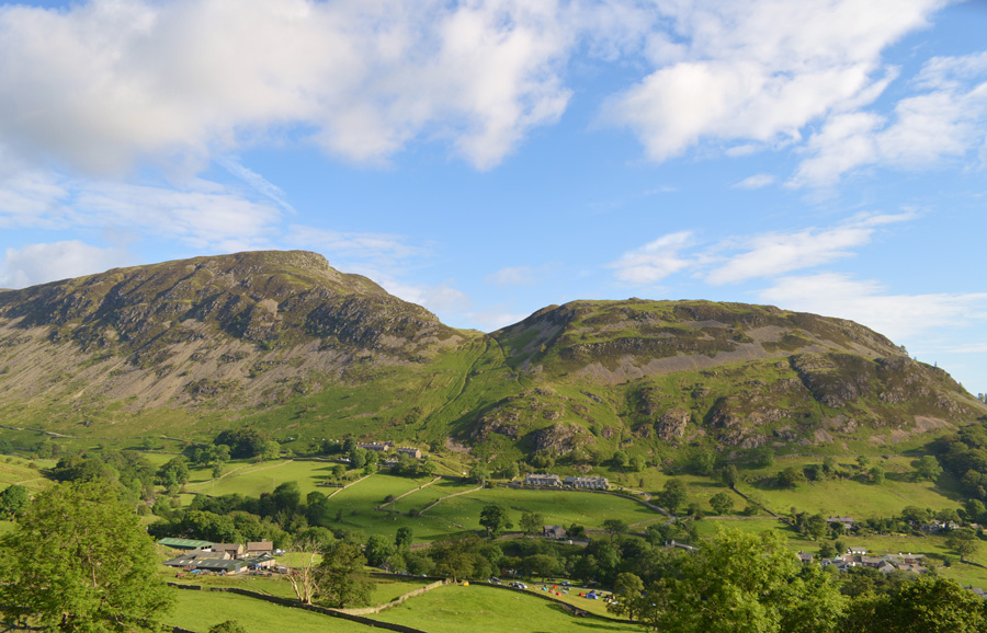 |
| Glenridding Dodd and Heron Pike seen over Glenridding. |
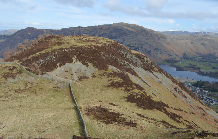 |
| Glenridding Dodd from the descent of Heron Pike. |
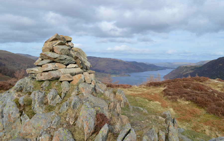 |
| Ullswater from Glenridding Pike summit. |
|
| |
|
There are 9 walks to choose from including Glenridding Dodd |
|
|
Glenridding Circuit |
|
|
 |
|
6th June 2025 |
| ASCENT: |
4,293 Feet - 1,308 Metres |
| MILES: |
12 |
| WAINWRIGHTS: |
9, Birkhouse Moor - Catstye Cam - Helvellyn - White Side - Raise - Stybarrow Dodd - Hart Side - Sheffield Pike - Glenridding Dodd |
| ROUTE: |
Glenridding - Rattlebeck Bridge - Mires Beck - Birkhouse Moor - Red Tarn - Catstye Cam - Swirrel Edge - Helvellyn - Helvellyn Lower Man - White Side - Raise - Top of Sticks Pass - Stybarrow Dodd - White Stones - Hart Side - Glencoyne Head - Nick Head - Sheffield Pike - Glenridding Dodd - The Rake - Greenside Road - Glenridding |
|
| |
|
Glenridding Dodd, Hart Side and the Glencoyne Traverse |
|
|
|
|
20th April 2024 |
| ASCENT: |
2,857 Feet - 870 Metres |
| MILES: |
7.8 |
| WAINWRIGHTS: |
3, Glenridding Dodd - Sheffield Pike - Hart Side |
| ROUTE: |
Stybarrow Crag - Ullswater Shore Path - Greenside Road - The Rake - Glenridding Dodd - Heron Pike - Sheffield Pike - Nick Head - Hart Side - Birkett Fell - Glencoyne Traverse - Nick Head - Seldom Seen - Stybarrow Crag |
|
| |
|
Raise from Glenridding |
|
|
|
|
11th February 2022 |
| ASCENT: |
3,447 Feet - 1,051 Metres |
| MILES: |
10 |
| WAINWRIGHTS: |
5, Glenridding Dodd - Sheffield Pike - Hart Side - Raise - White Side |
| ROUTE: |
Glenridding - Greenside Road - Glenridding Dodd - Heron Pike - Sheffield Pike - Nick Head - Glencoyne Head - Hart Side - White Stones - Top of Sticks Pass - Raise - White Side - Keppel Cove Zigzags - Glenridding Beck - Greenside Road - Glenridding |
|
| |
|
Sheffield Pike and Glenridding Dodd |
|
|
|
|
16th July 2020 |
| ASCENT: |
1,826 Feet - 557 Metres |
| MILES: |
4 |
| WAINWRIGHTS: |
2, Sheffield Pike - Glenridding Dodd |
| ROUTE: |
Stybarrow Crag - A592 - Seldom Seen - Glencoyne - Nick Head - Sheffield Pike - Heron Pike - Glenridding Dodd - Mossdale Beck |
|
| |
|
Walking the Birketts, Sheffield Pike |
|
|
|
|
28th December 2018 |
| ASCENT: |
1,920 Feet - 585 Metres |
| MILES: |
5 |
| BIRKETTS: |
3, Glenridding Dodd - Heron Pike - Sheffield Pike |
| ROUTE: |
Glenridding - Blaes Crag - The Rake - Glenridding Dodd - Heron Pike - Sheffield Pike - Nick Head - Seldom Seen - Lake Path Back to Glenridding - Glenridding |
|
| |
|
Walking the Wainwrights in 30 Walks - Walk 7 The Mell Fells to Glenridding Dodd |
|
|
|
|
25th March 2016 |
| ASCENT: |
4,800 Feet - 1,464 Meters |
| MILES: |
15 |
| WAINWRIGHTS: |
6, Great Mell Fell - Little Mell Fell - Gowbarrow Fell - Hart Side - Sheffield Pike - Glenridding Dodd |
| ROUTE: |
Brownrigg Farm - Great Mell Fell - Brownrigg Farm - Jenny Hill - The Hause - Little Mell Fell - The Hause - Great Meldrum - Gowbarrow Fell – Aira Beck – Park Brow - Watermillock Common – Birkett Fell – Hart Side – Glencoyne Head – Nick Head - Sheffield Pike – Heron Pike - Glenridding Dodd – The Rake - Greenside Road - Ullswater Shore Path - Stybarrow Crag
|
|
| |
|
Catstye Cam via the North West Ridge |
|
|
|
|
4th May 2013 |
| ASCENT: |
3,678 Feet, 1,121 Metres |
| MILES: |
9.8 |
| WAINWRIGHTS: |
6, Catstye Cam – Helvellyn – White Side – Raise – Sheffield Pike – Glenridding Dodd |
| ROUTE: |
Stybarrow Crag – Lake Path – Greenside Road – Greenside Mine – Glenridding Beck – Keppel Cove Dam – Catstye Cam North West Ridge – Catstye Cam – Swirral Edge – Helvellyn – Helvellyn Lower Man – White Side – Raise – Sticks Pass – Green Side – Nick Head – Sheffield Pike – Heron Pike – South East Ridge – Glenridding Dodd – Stybarrow Crag |
|
| |
|
A Glencoyne circuit |
|
|
|
|
6th January 2013 |
| ASCENT: |
1,690 Feet, 515 Metres |
| MILES: |
6.7 |
| WAINWRIGHTS: |
3, Glenridding Dodd – Sheffield Pike – Hart Side |
| ROUTE: |
Glenridding – Glenridding Dodd – Heron Pike – Sheffield Pike – Nick Head – Glencoyne Head – Hart Side – Brown Hills – Glencoyne – A592 – Lake Path – Glenridding |
|
| |
|
The Eastern Fells & Edge’s |
|
|
|
|
1st July 2011 |
| ASCENT: |
4,416 Feet 1,346 Meters |
| MILES: |
11 |
| WAINWRIGHTS: |
8, Birkhouse Moor, Helvellyn, White Side, Raise, Stybarrow Dodd, Hart Side, Sheffield Pike & Glenridding Dodd |
| ROUTE: |
|
|
| |
| Back to top |
 |
|

