 |
Hartsop Above How (Gill Crag) |
 |
 |
Map and Photo Gallery |
 |
|
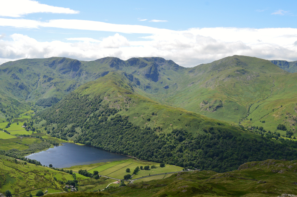 |
| Views over Brothers Water towards Dovedale, Dove Crag, Hart Crag, Hartsop above How, Deepdale, Fairfield and St Sunday Crag. |
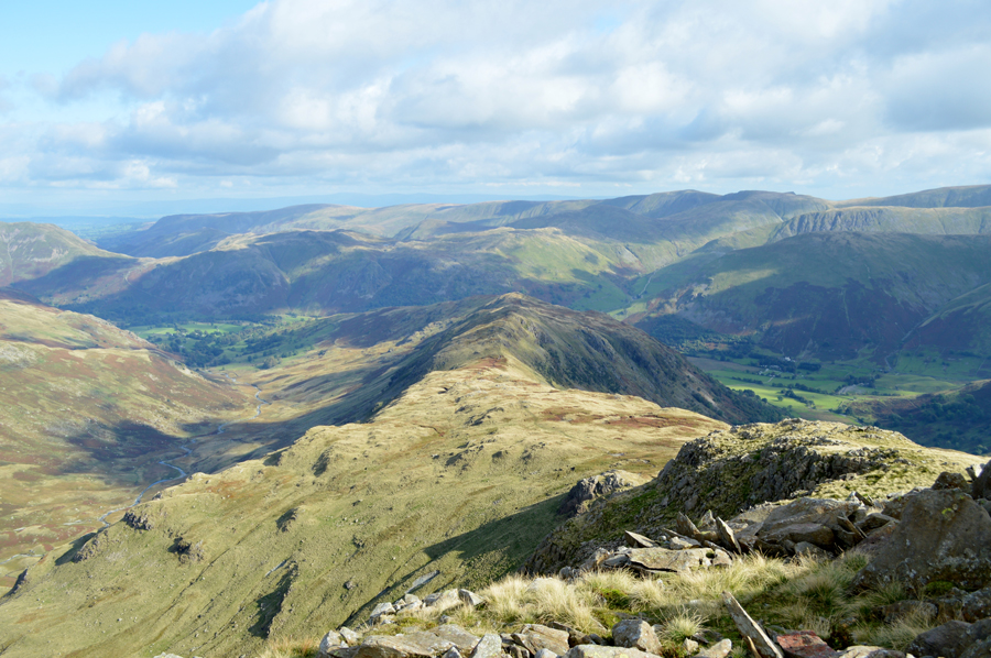 |
| The Hartsop Above Ridge taken below Hart Crag |
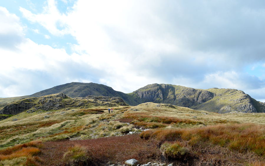 |
| Looking back on the Hartsop above How ridge towards Hart Crag and Fairfield |
|
| |
|
There are 8 walks to choose from including Hartsop above How |
|
|
Fairfield via Cawk Cove |
|
|
 |
|
21st July 2024 |
| ASCENT: |
2,680 Feet - 817 Metres |
| MILES: |
7.5 |
| WAINWRIGHTS: |
3, Fairfield - Hart Crag - Hartsop above How |
| ROUTE: |
Deepdale Bridge - Deepdale Hall - Wall End - Deepdale - Deepdale Beck - Mossydale - Cawk Cove - Cofa Pike - Fairfield - Link Hause - Hart Crag - Hartsop above How - Gale Crag - Deepdale Bridge |
|
| |
|
Hartsop above How, Dove Crag & Stangs |
|
|
|
|
23rd September 2023 |
| ASCENT: |
2,659 Feet - 810 Metres |
| MILES: |
8.1 |
| WAINWRIGHTS: |
3, Hartsop above How - Hart Crag - Dove Crag |
| ROUTE: |
Deepdale Bridge - Gale Crag - Harstop above How - Hart Crag - Dove Crag - Bakestones Moss - Hunsett Cove - Stand Crags - Stangs - Dovedale Beck - Dovedale - Hartsop Hall - Brothers Water - Cow Bridge - Low Wood - Deepdale Bidge |
|
| |
|
The Deepdale Horseshoe |
|
|
|
|
1st August 2020 |
| ASCENT: |
3,267 Feet - 997 Metres |
| MILES: |
7.5 |
| WAINWRIGHTS: |
4, Hartsop above Howe - Hart Crag - Fairfield - St Sunday Crag |
| ROUTE: |
Deepdale Bridge - Gale Crag - Hartsop above Howe - Hart Crag - Link Hause - Fairfield - Cofa Pike - St Sunday Crag - Gavel Pike - Lords Seat - Deepdale - Deepdale Bridge |
|
| |
|
Walking the Birketts, Deepdale Horseshoe |
|
|
|
|
14th April 2018 |
| ASCENT: |
3,521 Feet - 1,073 Metres |
| MILES: |
9.5 |
| BIRKETTS: |
9, Arnison Crag - Birks - Gavel Pike - St Sunday Crag - Cofa Pike - Fairfield - Hart Crag - Giil Crag (Hartsop above How) - Gale Crag |
| ROUTE: |
Patterdale - Oxford Crag - Arnison Crag - Trough Head - Birks - Gavel Pike - St Sunday Crag - Deepdale Hause - Cofa Pike - Fairfield - Link Hause - Hart Crag - Giil Crag (Hartsop above How) - Gale Crag - Deepdale Bridge - Patterdale |
|
| |
|
A Deepdale Horseshoe |
|
|
|
|
8th October 2016 |
| ASCENT: |
3,448 Feet - 1,051 Meters |
| MILES: |
10.2 |
| WAINWRIGHTS: |
6, Arnison Crag - Birks - St Sunday Crag - Fairfield - Hart Crag - Hartsop above How |
| ROUTE: |
Patterdale - Arnison Crag - Trough Head - Birks - St Sunday Crag - Deepdale Hause - Cofa Pike - Fairfield - Hart Crag - Hartsop Above How - Deepdale Bridge - A592 – Patterdale |
|
| |
|
Walking the Wainwrights in 30 Walks Walk 28 - A Scandale Skyline from Cow Bridge |
|
|
|
|
18th August 2016 |
| ASCENT: |
4,932 Feet - 1,504 Meters
|
| MILES: |
12.5 |
| WAINWRIGHTS: |
9, Hartsop Dodd - Caudale Moor (Stony Cove Pike) - Red Screes - Middle Dodd - Little Hart Crag - High Hartsop Dodd - Dove Crag - Hart Crag - Hartsop above How |
| ROUTE: |
Hartsop - Hartsop Dodd - Caudale Moor (Stony Cove Pike) - John Bell's Banner - St Raven's Edge - Kirkstone Pass - Red Screes - Smallthwaite Band - Middle Dodd - Top of Caiston Beck - Scandale Pass - Little Hart Crag - High Hartsop Dodd - Black Brow - Bakestones Moss - Dove Crag - Hart Crag - Hartsop above How - Gale Crag - Low Wood - Cow Bridge - Hartsop |
|
| |
|
The Deepdale Horseshoe |
|
|
|
|
8th September 2013 |
| ASCENT: |
3,450 Ft, 1,052 Meters |
| MILES: |
10.2 |
| WAINWRIGHTS: |
5, Birks – St Sunday Crag – Fairfield – Hart Crag – Hartsop Above How |
| ROUTE: |
Bridgend – A592 – Glenamara Park – Thornhow End – Birks – St Sunday Crag – Deepdale Hause – Cofa Pike – Fairfield – Link Hause – Hart Crag – Hartsop Above How – Gale Crag – Bridgend |
|
| |
|
The Dovedale Horseshoe |
|
|
|
|
15th August 2010 |
| ASCENT: |
2,760 Ft 841 Mtrs |
| MILES: |
7 |
| WAINWRIGHTS: |
5, Hartsop Above How, Hart Crag, Dove Crag, Little Hart Crag High Hartsop Dodd |
| ROUTE: |
|
|
| |
| Back to top |
 |
|

