|
High Raise (Langdale) |
 |
 |
Map and Photo Gallery |
 |
|
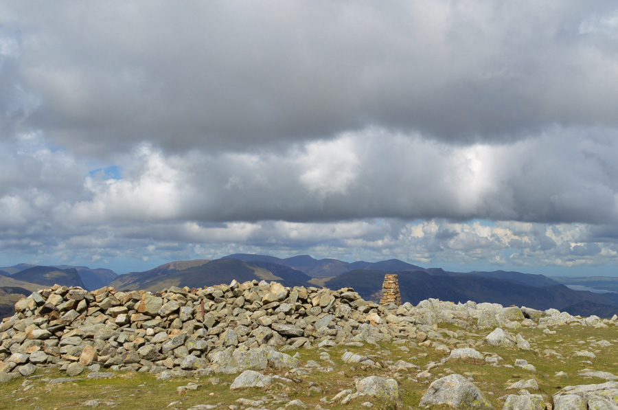 |
| High Raise summit Trig Point and shelter. |
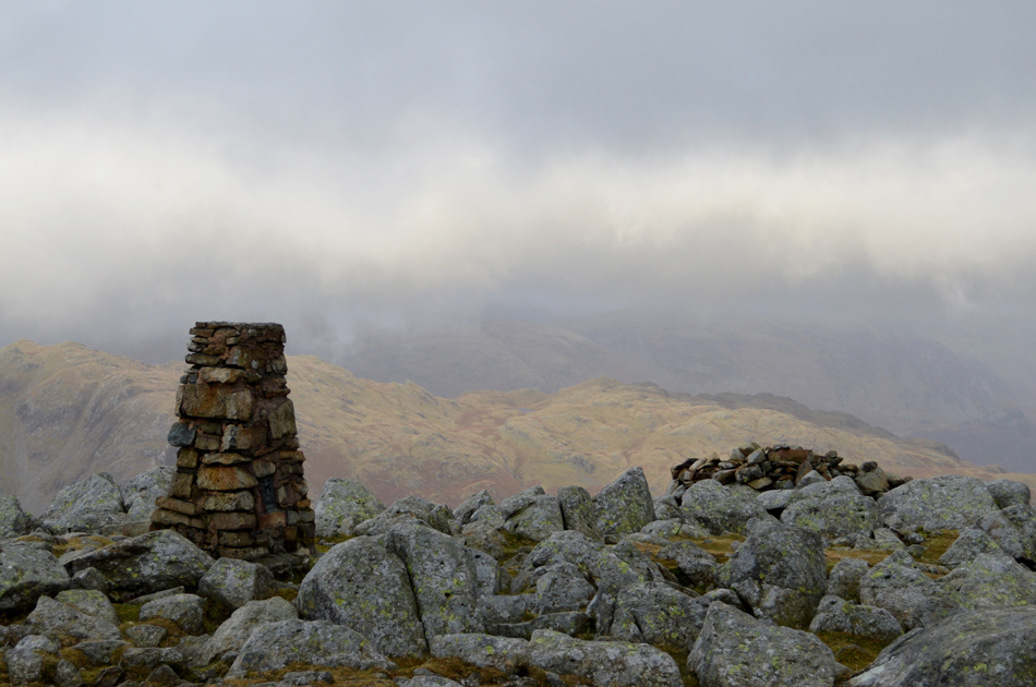 |
| High Raise summit Trig Point. |
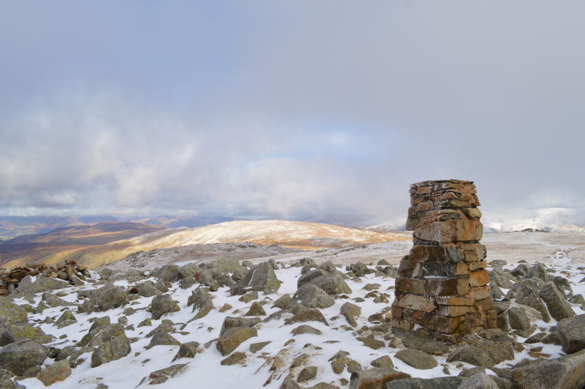 |
| High Raise with the Ullscarf beyond |
|
| |
|
There are 7 walks to choose from including High Raise (Langdale) |
|
|
Harrison Stickle and High Raise from Great Langdale |
|
|
 |
|
10th December 2016 |
| ASCENT: |
2,752 Feet - 839 Meters |
| MILES: |
6.5 |
| WAINWRIGHTS: |
4, Harrison Stickle - Thunacar Knott - Haigh Raise (Langdale) - Sergeant Man |
| ROUTE: |
Rossett Bridge - New Dungeon Ghyll - Pike Howe - Dungeon Ghyll - Harrison Stickle - Thunacar Knott - High Raise (Langdale) - Segeant Man - Stickle Tarn - Stickle Ghyll - New Dungeon Ghyll - Rossett Bridge |
|
| |
|
Walking the Wainwrights in 30 Walks - Walk 14 The Langdale Pikes from Grasmere |
|
|
|
|
22nd May 2016 |
| ASCENT: |
3'440 Feet - 1,092 Meters |
| MILES: |
13 |
| WAINWRIGHTS: |
9, Silver How - Blea Rigg - Harrison Stickle - Loft Crag - Pike O'Stickle - Thunacar Knott - Pavey Ark - High Raise (Langdale) - Tarn Crag (Easedale) |
| ROUTE: |
Grasmere - Kelbarrow - Silver How - Lang How Tarn - Blea Rigg - Stickle Tarn - Harrison Stickle - Harrison Combe - Loft Crag - Pike O'Stickle - Harrison Combe - Thunacar Knott - Pavey Ark - High Raise (Langdale) - Coledale Head - Lang Crag - Tarn Crag (Easedale) - Easedale Tarn - Sourmilk Gill - Goody Bridge - Easdale Road - Grasmere |
|
| |
|
The Harry Griffin 2,000 footers Walk 1 -The Langdale Pikes |
|
|
|
|
21st February 2015 |
| ASCENT: |
3,540 Feet - 1,079 Meters |
| MILES: |
11 |
| SUMMITS OVER 2,000 Ft |
9,Harrison Stickle - Loft Crag - Pike O'Stickle - Thunacar Knott South Top - Thunacar Knott North Top - Pavey Ark - High Raise (Langstrath) - Ullscarth - Segeant Man |
| ROUTE: |
Stickle Barn - Pike How - Thorn Crag - Harrison Stickle - Loft Crag - Pike O'Stickle - Thunacar Knott - Pavey Ark - High Raise - Low White Stones - Greenup Edge - Ullscarth - Greenup Edge - Low White Stones - High Raise - Sergeant Man -Stickle Tarn - Stickle Ghyll - Stickle Barn |
|
| |
|
The Wythburn Fells |
|
|
|
|
23rd November 2012 |
| ASCENT: |
798 Metres, 2,618 Feet |
| MILES: |
9.6 |
| WAINWRIGHTS: |
4, Ullscarth – High Raise – Calf Crag – Steel Fell |
| ROUTE: |
Wythburn – Birk Crag – Harrop Tarn – Mosshause Gill – Standing Crag – Ullscarth – Greenup Edge – Low White Stones – High Raise – Sergeant Man – Deep Slack – Brownrigg Moss – Steel Fell – Steel Fell North Ridge – Steel End – Wythburn |
|
| |
|
High on Langstrath |
|
|
|
|
20th May 2012 |
| ASCENT: |
3,850 Feet, 1,173 Metres |
| MILES: |
12.5 |
| WAINWRIGHTS: |
4, Eagle Crag, Sergeant’s Crag, High Raise, Rossett Pike |
| ROUTE: |
Stonethwaite – Greenup Gill – Eagle Crag – Sergeant’s Crag – Low White Stones – High Raise – Stake Pass – Buck Pike – Rossett Pike – Angle Tarn – Langstrath Valley – Tray Dub – Blackmoss Pot – Stonethwaite |
|
| |
|
High Raise from Grasmere via Helm Crag |
|
|
|
|
7th January 2012 |
| ASCENT: |
2,800 Feet, 854 Meters |
| MILES: |
9.6 |
| WAINWRIGHTS: |
5, Helm Crag, Gibson Knott, Calf Crag, High Raise, Sergeant Man |
| ROUTE: |
Grasmere – Easedale Road – Helm Crag – Gibson Knott – Calf Crag – Brownrigg Moss – Mere Beck – High Raise – Sergeant Man – Easedale Tarn – Easedale – Grasmere |
|
| |
|
Sergeant Man & High Raise |
|
|
|
|
27th February 2010 |
| ASCENT: |
762 Mtrs 2500Ft |
| MILES: |
10 |
| WAINWRIGHTS: |
3 Blea Rigg, Sergeant Man,High Raise |
| ROUTE: |
|
|
| |
| Back to top |
 |
|