|
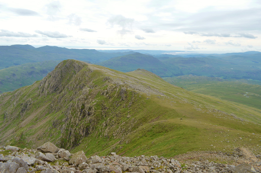
Slight Side |
 |
 |
There are 10 walks to choose from including Slight Side |
 |
|
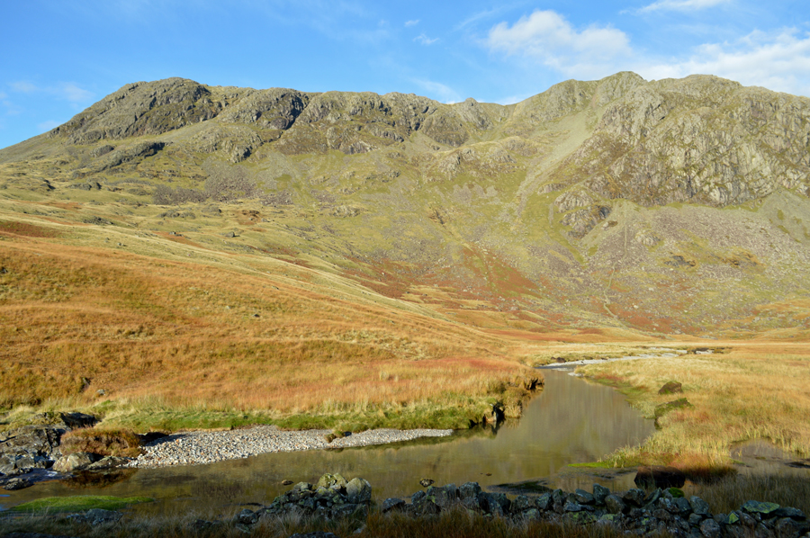
Hard Knott, Cam Spout Crag & Slight Side from Jubilee Bridge |
|
|
 |
|
17th July 2021 |
| ASCENT: |
3,578 Feet - 1,091 Metres |
| MILES: |
10 |
| WAINWRIGHTS: |
2, Hard Knott - Slight Side |
| ROUTE: |
Jubilee Bridge - Hard Knott Pass - Hardknott Roman Fort - Border End - Hard Knott - Yew Bank - Lingcove Beck - Great Moss - River Esk - Cam Spout - How Beck - Cam Spout North Ridge - Cam Spout Crag - Long Green - Slight Side - Traverse Below Horn Crag - High Scarth Crag - Scale Bridge - Taw House - Brotherilkeld - Jubilee Bridge |
|
| |
|
The Eskdale Horseshoe |
|
|
|
|
19th September 2020 |
| ASCENT: |
5,320 Feet - 1,622 Metres |
| MILES: |
14 |
| WAINWRIGHTS: |
7, Crinkle Crags - Bow Fell - Esk Pike - Great End - Scafell Pike - Sca Fell - Slight Side |
| ROUTE: |
Cockley Beck - Moasdale - Adam-a-Cove - Long Top (Crinkle Crags) - Three Tarns - Bow Fell - Ore Gap - Esk Pike - Esk Hause - Calf Cove - Great End - III Crag - Broad Crag - Broad Crag Col - Scafell Pike - Mickledore - Rake's Progress - Lord's Rake - Sca Fell - Long Green - Slight Side - High Scarth Crag - River Esk - Lingcove Beck - Moasdale - Cockley Beck |
|
| |
|
Walking the Birketts, Scafell Pike via Pen, Scafell via Deep Gill SCA 2A |
|
|
|
|
27th May 2018 |
| ASCENT: |
3,904 Feet - 1,191 Metres |
| MILES: |
10.7 |
| BIRKETTS: |
4, Pen - Scafell Pike - Scafell - Slight Side |
| ROUTE: |
Jubilee Bridge - Brotherilkeld - Great Moss - Little Narrowcove - Pen - Eskdale Cairn - Rough Crag - Scafell Pike - Mickeldore - Rakes Progress - Lord's Rake - West Wall Tarverse - Deep Gill - Symonds Knott - Scafell - Long Green - Slight Side - Top of Cat Gill - Taw House Farm - Brotherilkeld - Jubiliee Bridge |
|
| |
|
Pen, Scafell Pike and Scafell via Lord's Rake and the West Wall Traverse |
|
|
|
|
22nd October 2016 |
| ASCENT: |
3,967 Feet - 1,209 Meters |
| MILES: |
10.3 |
| WAINWRIGHTS: |
3, Scafell Pike - Scafell - Slight Side |
| ROUTE: |
Jubilee Bridge - Brotherilkeld - Lingcove Bridge - River Esk - Pen - Rough Crag - Scafell Pike - Mickledore - Rakes Progress - Lord's Rake - West Wall Traverse - Deep Gill - Symonds Knott - Scafell - Long Green - Slight Side - Catcove Beck - Taw House - Brotherilkeld - Jubilee Bridge |
|
| |
|
Walking the Wainwrights in 30 Walks - Walk 24 The Scafells and Illgill Head |
|
|
|
|
23rd July 2016 |
| ASCENT: |
5,413 Feet - 1,650 Meters |
| MILES: |
13 |
| WAINWRIGHTS: |
6, Lingmell - Scafell Pike - Scafell - Slight Side - IIIgill Head - Whin Rigg |
| ROUTE: |
Wasdale Head - Brackenclose - Lingmell - Lingmell Col - Scafell Pike - Mickledore - Foxs Tarn Gully - Foxs Tarn - Scafell - Long Green - Slight Side - Hardrigg Gill - Maiden Castle Cairn - IIIgill Head - Whin Rigg - Greathall Gill - Wast Water |
|
| |
|
The Harry Griffin 2,000 footers Walk 27 -The Roof of England |
|
|
|
|
13th September 2015 |
| ASCENT: |
5,061 Feet - 1,543 Meters |
| MILES: |
11 |
| SUMMITS OVER 2'000Ft: |
5, Lingmell - Scafell Pike - Scafell - Cam Spout Crag - Slight Side |
| ROUTE: |
Wasdale Head - Down in the Dale - Brackenclose - Lingmell - Lingmell Col - Scafell Pike - Mickledore - Foxes Tarn gully - Mickledore - Lord's Rake - Scafell - Long Green - Slight Side - Long Gill - Hardrigg Gill - Hard Rigg - Corpse Road - Brackenclose - Down in the Dale - Wasdale Head |
|
| |
|
Scafell & Slight Side from Eskdale Green |
|
|
|
|
7th August 2014 |
| ASCENT: |
4,100 Feet – 1,249 Meters |
| MILES: |
15 |
| WAINWRIGHTS: |
2, Scafell – Slight Side |
| ROUTE: |
Eskdale Green – Giggle Alley – Porterthwaite – Miterdale – Low Place – Miterdale Head – Burnmoor Tarn – Burnmoor Lodge – Bulatt Bridge – Hard Rigg – Green How – Scafell –Long Green – Slight Side – Broad Tongue – Hardrigg Gill – Bulatt Bridge – Eskdale Moor – Brat’s Moss – Blea Tarn – Fell End – Hollin How – Eskdale Green |
|
| |
|
Pen, The Scafells & Lord’s Rake |
|
|
|
|
25th August 2013 |
| ASCENT: |
3,920ft 1,192 Meters |
| MILES: |
10 |
| WAINWRIGHTS: |
3, Scafell Pike – Scafell – Slight Side |
| ROUTE: |
Brotherilkeld – River Esk – Taw House – Scale Bridge – Sampson’s Stones – Great Moss – Pen – Rough Crag –Scafell Pike South Ridge – Scafell Pike – Mickledore – Rakes Progress – Lord’s Rake – Scafell – Long Green – Slight Side – Catcove Beck – Taw House – River Esk – Brotherilkeld |
|
| |
|
Nothing better than this… |
|
|
|
|
27th May 2012 |
| ASCENT: |
4,509 Feet, 1,377 Metres |
| MILES: |
9.6 |
| WAINWRIGHTS: |
4, Lingmell, Scafell Pike, Scafell, Slight Side |
| ROUTE: |
Wasdale Head – Down In The Dale – Brackenclose – Lingmell – Lingmell Col – Scafell Pike – Lords Rake – Scafell – Long Green – Slight Side – Quargrigg Moss – Great How – Burnmoor Tarn – Down In The Dale – Wasdale Head |
|
| |
|
Lingmell To Slight Side via The Scafell’s |
|
|
|
|
4th September 2011 |
| ASCENT: |
4,500 Feet, 1,372 Meters |
| MILES: |
9.7 |
| WAINWRIGHTS: |
4, Lingmell, Scafell Pike, Sca Fell & Slight Side |
| ROUTE: |
Brackenclose, Lingmell, Lingmell Col, Scafell Pike, Lords Rake, Sca Fell, Long Green, Slight Side, Quagrigg Moss, Broad Tongue, Burnmoor Tarn, Wasdale Head |
|
| |
| Back to top |
 |
|