 |
Gale Fell |
 |
 |
Overview |
 |
|
| Height: |
1,699 Feet - 518 Metres |
| Grid Ref: |
NY 133 163 |
| Area: |
Western |
| Group: |
W/HIG |
| Ordnance Survey: |
OL4 |
|
| |
|
Map and Photo Gallery |
|
|
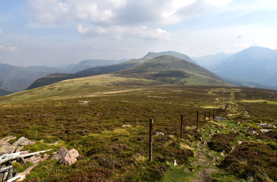 |
| Looking back on Gale Fell (left) Starling Dodd, Red Pike (Buttermere) Blea Crag and Lingcomb Edge. |
| |
|
| |
|
Walks including Gale Fell are:- |
|
|
Mellbreak, Red Pike & Great Borne from Loweswater |
|
|
 |
|
8th September 2023 |
| ASCENT: |
4,346 Feet - 1, 324 Metres |
| MILES: |
10.5 |
| WAINWRIGHTS: |
5, Mellbreak - Red Pike (Buttermere) - Starling Dodd - Great Borne - Hen Comb |
| ROUTE: |
Loweswater – Kirkgate Farm – White Crag – Mellbreak – Scale Force – Lingcomb Edge – Red Pike (Buttermere) – Little Dodd – Starling Dodd – Gale Fell - Scaw Well – Great Borne – Steel Brow – Floutern Tarn – Whiteoak Moss – Hen Comb - Mosedale Beck – Kirkgate Farm – Loweswater |
|
| |
|
The Ennerdale Horseshoe |
|
|
|
|
3rd June 2019 |
| ASCENT: |
7,700 Feet - 2,348 Metres |
| MILES: |
24 |
| WAINWRIGHTS: |
14, Great Borne - Starling Dodd - Red Pike (Buttermere) - High Stile - High Crag - Haystacks - Brandreth - Green Gable - Kirk Fell - Pillar - Scoat Fell - Haycock - Caw Fell - Crag Fell |
| ROUTE: |
Bleach Green - Ennerdale Water - Bowness - Herdus - Great Borne - Starling Dodd - Red Pike (Buttermere) - High Stile - High Crag - Gamlin End - Seat - Top of Scarth Gap - Haystacks - Innominate Tarn - Moses trod - Brandreth - Gillercomb Head - Green Gable - Windy Gap - Beck Head - Kirk Fell North Top - Kirk Fell - Baysour Slack - Top of Black Sail Pass - Looking Stead - Pillar - Wind Gap - Black Crag - Scoat Fell - Haycock - Caw Fell - Iron Crag - Crag Fell - Ben Gill - Crag Fell Farm - Bleach Green |
|
| |
|
Walking the Wainwrights in 30 Walks - Walk 15 Fleetwith Pike to Great Borne |
|
|
|
|
28th May 2016 |
| ASCENT: |
4,500 Feet - 1,373 Meters |
| MILES: |
13.5 |
| WAINWRIGHTS: |
7, Fleetwith Pike - Hay Stacks - High Crag - High Stile - Red Pike (Buttermere) - Starling Dodd - Great Borne
|
| ROUTE: |
Top of Honister Pass - Honister Mines - Fleetwith Pike - Dubs Bottom - Blackbeck Tarn - Innominate Tarn - Hay Stacks - Top of Scarth Gap Pass - Seat - Gamlin End - High Crag - High Stile - Red Pike (Buttermere) - Dodd - Little Dodd - Starling Dodd - Great Borne - Floutern Tarn - Whiteoak Moss - Scales Force - Buttermere Dubbs - The Fish Hotel, Buttermere
|
|
| |
|
The Harry Griffin 2,000 footers Walk 7 -The Buttermere Skyline |
|
|
|
|
18th April 2015 |
| ASCENT: |
4,000 Feet - 1,219 Metres |
| MILES: |
14.5 |
| SUMMITS OVER 2,000 Ft: |
Honister Crag - Fleetwith Pike South West Top - Fleetwith Pike - High Crag - High Stile - Chapel Crags - Red Pike (Buttermere) - Dodd - Starling Dodd - Great Borne - Great Borne North Top |
| ROUTE: |
Top of Honister Pass - Honister Mines - Fleetwith Pike - Dubs Bottom - Blackbeck Tarn - Innominate Tarn - Hay Stacks - Top of Scarth Gap Pass - Seat - Gamlin End - High Crag - High Stile - Red Pike (Buttermere) - Little Dodd - Starling Dodd - Great Borne - Top of Red Gill - Whiteoak Moss - Scales Force - Buttermere Dubbs - The Fish Inn, Buttermere
|
|
| |
|
Mellbreak, Red Pike & Great Borne |
|
|
|
|
29th September 2013 |
| ASCENT: |
2,526ft, 770 Meters |
| MILES: |
11.7 |
| WAINWRIGHTS: |
4, Mellbreak – Red Pike (Buttermere) – Starling Dodd – Great Borne |
| ROUTE: |
Loweswater – Kirkgate Farm – White Crag – Mellbreak – Scale Force – Lingcomb Edge – Red Pike (Buttermere) – Little Dodd – Starling Dodd – Scaw Well – Great Borne – Herdus – Steel Brow – Floutern Tarn – Whiteoak Moss – Mosedale – Mosedale Beck – Kirkgate Farm – Loweswater |
|
| |
|
The High Stile Ridge |
|
|
|
|
30th January 2011 |
| ASCENT: |
2,950 Feet, 899.1 Meters |
| MILES: |
11.9 |
| WAINWRIGHTS: |
5, High Crag, High Stile, Red Pike, Starling Dodd & Great Borne |
| ROUTE: |
|
|
| |
| Back to top |
 |
|
