|
Parking Information for - Car Park, Wetsleddale Dam (Reservoir) |
 |
 |
Parking Details and Map |
 |
|
| Nearest Post Code: |
CA10 3NE |
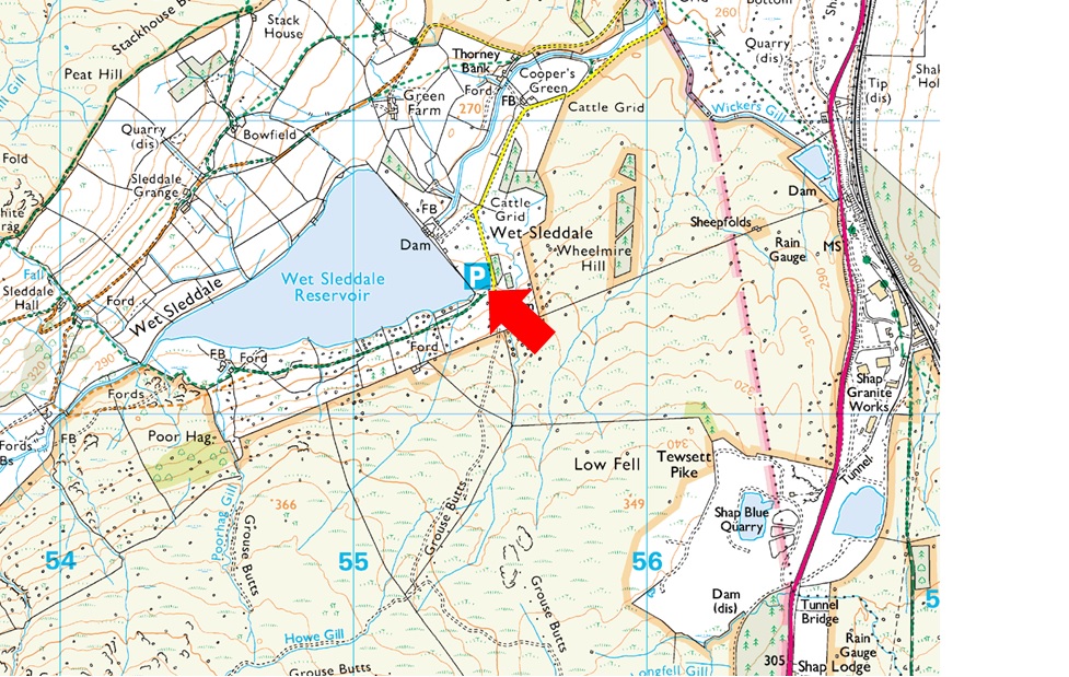
| Grid Reference: |
NY 554 611 |
| Notes: |
Follow the road sign posted Wet Sleddale Dam from the A6 (The Dam wall can clearly be seen from the A6) which will lead you onto the car park at the south east corner of the Dam Wall. The car park is quite small and isolated but you shouldny have trouble parking here even during peak times if you time your arrival before the crowds arrive. |
|
| |
|
Walks starting from this parking place |
|
|
|
Whatshaw Common to Seat Robert |
|
|
 |
|
31st July 2021 |
| ASCENT: |
2,000 Feet - 610 Metres |
| MILES: |
12.5 |
| WAINWRIGHTS: |
2, Tarn Crag (Longsleddale) - Grey Crag |
| ROUTE: |
A6 Shap Road Summit - Whatshaw Common - Little Yarlside - Great Yarlside - Harrop Pike - Grey Crag - Greycrag Tarn - Tarn Crag - Mosedale Cottage - Mosedale Beck - Scam Matthew - High Wether Howe - Seat Robert - Sleddale Hall - Wet Sleddale Reservoir |
|
| |
|
Walking the Birketts, Sleddale Pike and Wasdale Pike above Wet Sleddale |
|
|
|
|
1st June 2020 |
| ASCENT: |
985 Feet - 300 Metres |
| MILES: |
9.5 |
| BIRKETTS: |
4, Sleddale Pike - Wasdale Pike - Great Saddle Crag - Ulthwaite Rigg |
| ROUTE: |
Wet Sleddale Dam - Poorhag Gill - Lunch House - Howe Gill - Gray Bull - Sleddale Pike - Great Saddle Crag - Ulthwaite Rigg - Sleddale Hall - Wet Sleddale Dam |
|
| |
|
The Wet Sleddale Horseshoe |
|
|
|
|
18th March 2012 |
| ASCENT: |
2,300 Feet, 702 Metres |
| MILES: |
14 |
| WAINWRIGHTS: |
2, Grey Crag, Tarn Crag (Longsleddale) |
| ROUTE: |
Wet Sleddale Reservoir Dam – Lunch House – Gray Bull – Sleddale Pike – Great Saddle Crag – Great Yarlside – Harrop Pike – Grey Crag – Tarn Crag, Longsleddale – Brunt Tongue – Mosedale Beck – Scam Mathew – High Wether Howe – Haskew Tarn – Seat Robert – Willy Fold – Sleddale Hall – Wet Sleddale Reservoir Dam |
|
| |
|
| |
| Back to top |
 |
|