|
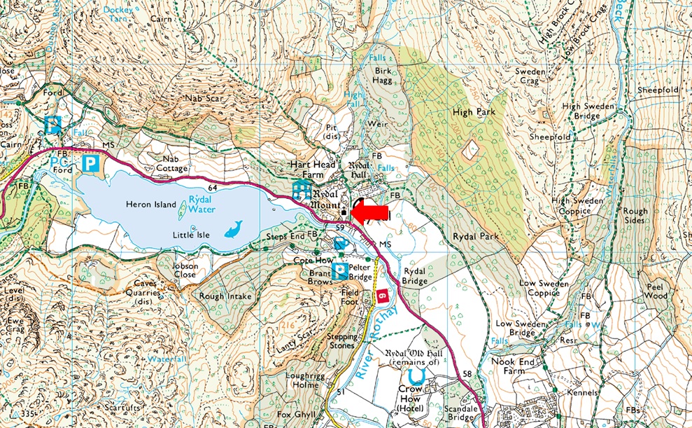
Parking Information for - Roadside Parking, Rydal (Church) |
 |
 |
Parking Details and Map |
 |
|
| Nearest Post Code: |
LA22 9LR |
| Grid Reference: |
NY 364 706 |
| Notes: |
UPDATE Spring 2026 Sadly parking at Rydal Mount is now prohibited - Alternative parking can be found at Pelter Bridge (LA22 9LW) Rydal Road Car Park (LA22 9AN) or Rydal Water Car Park (LA22 9SE) |
|
| |
|
Photos |
|
|
|
| |
|
Walks starting from this parking place |
|
|
|
The Fairfield Horseshoe |
|
|
 |
|
13th March 2025 |
| ASCENT: |
3,356 Feet - 1,024 Metres |
| MILES: |
10 |
| WAINWRIGHTS: |
8, Nab Scar - Heron Pike - Great Rigg - Fairfield - Hart Crag - Dove Crag - High Pike - Low Pike |
| ROUTE: |
Rydal Church - Rydal Mount - Nab Scar - Heron Pike - Erne Crag - Rydal Fell - Great Rigg - Fairfield - Link Hause - Hart Crag - Dove Crag - High Pike - Low Pike - Low Sweden Bridge - Rydal Park - Rydal Mount - Rydal Church |
|
| |
|
Nab Scar to Stone Arthur from Rydal |
|
|
|
|
24th February 2024 |
| ASCENT: |
2,424 Feet - 739 Metres |
| MILES: |
6.5 |
| WAINWRIGHTS: |
4, Nab Scar - Heron Pike - Great Rigg - Stone Arthur |
| ROUTE: |
Rydal Mount - Nab Scar - Heron Pike - Erne Crag - Rydal Fell - Great Rigg - Stone Arthur - Greenhead Gill - A591 - Grasmere - A591 |
|
| |
|
Nab Scar, Alcock Tarn and Loughrigg Fell |
|
|
|
|
22nd February 2020 |
| ASCENT: |
1,407 Feet 429 Metres |
| MILES: |
6.2 |
| WAINWRIGHTS: |
Loughrigg Fell |
| ROUTE: |
Rydal Church - Pelter Bridge - Loughrigg Cave - Loughrigg Terrace - Loughrigg Fell - Lanty Tarn - Miller Bridge - Ambleside - Rydal Hall - Rydal Church |
|
| |
|
Nab Scar, Alcock Tarn and Loughrigg Fell |
|
|
|
|
24th September 2017 |
| ASCENT: |
2,572 Feet 784 Metres |
| MILES: |
6.2 |
| WAINWRIGHTS: |
2, Nab Scar - Loughrigg Fell |
| ROUTE: |
Rydal Church - Nab Scar - Allcock Tarn - Brackenfell Wood - A591 - Loughrigg Terrace - Loughrigg Fell - Loughrigg Cave - Rydal Water - Rydal Church - Rydal Hall - Rydal Church |
|
| |
|
Walking the Wainwrights in 30 Walks - Walk 3 The Fairfield Horseshoe |
|
|
|
|
14th February 2016 |
| ASCENT: |
4,436 Feet - 1'352 Meters |
| MILES: |
13 |
| WAINWRIGHTS: |
9, Nab Scar - Heron Pike - Stone Arthur - Great Rigg - Fairfield - Hart Crag - Dove Crag - High Pike - Low Pike |
| ROUTE: |
Pelter Bridge - A591 - Rydal Mount - Nab Scar - Heron Pike - Greenhead Gill - Stone Arthur - Great Rigg - Fairfield - Hart Crag - Dove Crag - High Pike - Low Pike - Low Sweden Copice - Rydal Park - Rydal Mount - A591 - Pelter Bridge |
|
| |
|
Nab Scar, Alcock Tarn and Loughrigg Fell |
|
|
|
|
13th December 2015 |
| ASCENT: |
2,621 Feet - 799 Meters |
| MILES: |
8 |
| WAINWRIGHTS: |
2, Nab Scar - Loughrigg Fell |
| ROUTE: |
Rydal Church - Nab Scar - Allcock Tarn - Brackenfell - Old Coffin Route Rydal Church - Rydal Water - Loughrigg Terrace - Loughrigg Fell - Loughrigg Caves - Rydal Hall - Rydal Church |
|
| |
|
Great Rigg from Rydal |
|
|
|
|
7th December 2012 |
| ASCENT: |
696 Metres, 2,283 Feet |
| MILES: |
7.3 |
| WAINWRIGHTS: |
4, Nab Scar – Heron Pike – Great Rigg – Stone Arthur |
| ROUTE: |
Rydal – Nab Scar – Heron Pike – Great Rigg – Stone Arthur – Greenhead Gill – Alcock Tarn – Brackenfell Woods – Rydal Coffin Route – Rydal |
|
| |
|
The Fairfield Horseshoe |
|
|
|
|
28th May 2011 |
| ASCENT: |
3,420 Feet |
| MILES: |
9 |
| WAINWRIGHTS: |
8, Nab Scar, Heron Pike, Great Rigg, Fairfield, Hart Crag, Dove Crag, High Pike (Scandale) & Low Pike |
| ROUTE: |
|
|
| |
|
| |
| Back to top |
 |
|