|
Parking Information for - Stonethwaite Village |
 |
 |
Parking Details and Map |
 |
|
| Nearest Post Code: |
CA12 5XG |
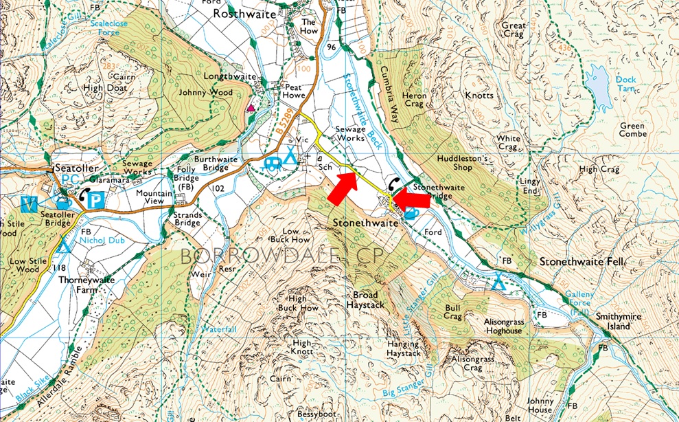
| Grid Reference: |
NY 260513 (Stonthwaite School) - NY 262 513 (Next to Phonebox) |
| Notes: |
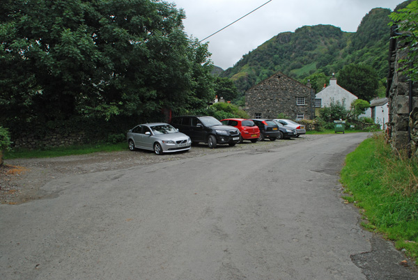
There are two places to park in the village of Stonethwaite the first one being as you head into the village itself just after the school with parking for up to three cars, further into the village next to the red phone box the is a small parking area with room for up to half a dozen cars. Both sites are ideal if heading into the beautiful Langstrath valley, Eagle Crag or Sergeants Crag. My advise is to arrive early to secure parking places and you wont be disappointed. Parking is free, |
|
| |
|
Photos |
|
|
|
| |
|
Walks starting from this parking place |
|
|
|
Rossett Pike from Stonethwaite |
|
|
 |
|
10th July 2021 |
| ASCENT: |
2,316 Feet 706 Metres |
| MILES: |
12.5 |
| WAINWRIGHTS: |
Rossett Pike |
| ROUTE: |
Stonethwaite - Langstrath - Blea Rock - Blackmoss Pot - Stake Pass - Rossett Pike - Angle Tarn - Angletarn Gill - Langstrath - Tray Dub - Blackmoss Pot - Stonethwaite Campsite - Stonethwaite |
|
| |
|
Great Crag & Grange Fell from Stonethwaite |
|
|
|
|
7th October 2020 |
| ASCENT: |
2,000 Feet – 610 Metres |
| MILES: |
6.5 |
| WAINWRIGHTS: |
2, Great Crag – Grange Fell |
| ROUTE: |
Stonethwaite – Lingy End – Dock Tarn – Great Crag – Watendlath Tarn – Watendlath – Puddingstone Bank – Grange Fell – Puddingstone Bank – Rosthwaite – Stonethwaite |
|
| |
|
The Wainwrights in 30 Walks - Walk 22 Eagle Crag to Castle Crag via Greenup Edge |
|
|
|
|
8th July 2016 |
| ASCENT: |
3,643 Feet - 1,112 Meters |
| MILES: |
14.3 |
| WAINWRIGHTS: |
6, Eagle Crag - Sergeant's Crag - UIlscarf - Great Crag - Grange Fell - Eagle Crag |
| ROUTE: |
Stonethwaite - Greenup Gill - Eagle Crag - Sergeants Crag - Long Crag - Greenup Edge - Ullscarth - High Saddle - Low Saddle - Dock Tarn - Great Crag - Top of Puddingstone Bank - Grange Fell - Puddingstone Bank -Rosthwaite - River Derwent - New Bridge - Castle Crag Lingy Bank - River Derwent - Rosthwaite - B5289 - Stonethwaite |
|
| |
|
Great Crag & Grange Fell from Stonethwaite |
|
|
|
|
8th February 2015 |
| ASCENT: |
2,000 Feet – 610 Meters |
| MILES: |
6.5 |
| WAINWRIGHTS: |
2, Great Crag – Grange Fell |
| ROUTE: |
Stonethwaite – Lingy End – Dock Tarn – Great Crag – Watendlath Tarn – Watendlath – Puddingstone Bank – Grange Fell – Puddingstone Bank – Rosthwaite – Stonethwaite |
|
| |
|
Eagle Crag to Grange Fell via Greenup Edge |
|
|
|
|
31st August 2013 |
| ASCENT: |
2,464 Feet 751 Meters |
| MILES: |
10.4 |
| WAINWRIGHTS: |
5, Eagle Crag – Sergeant’s Crag – Ullscarf – Great Crag – Grange Fell |
| ROUTE: |
Stonethwaite – Greenup Gill – Eagle Crag – Sergeant’s Crag – Beneath Long Crag – Greenup Edge – Ullscarth – High Saddle (Coldbarrow Fell) – Low Saddle – (Coldbarrow Fell) – Lords How -Green Combe – Dock Tarn – Great Crag – Puddingstone Bank – Grange Fell – Puddingstone Bank – Cumbrian Way – Stonethwaite Bridge – Stonethwaite |
|
| |
|
High on Langstrath |
|
|
|
|
20th May 2012 |
| ASCENT: |
3,850 Feet, 1,173 Metres |
| MILES: |
12.5 |
| WAINWRIGHTS: |
4, Eagle Crag, Sergeant’s Crag, High Raise, Rossett Pike |
| ROUTE: |
Stonethwaite – Greenup Gill – Eagle Crag – Sergeant’s Crag – Low White Stones – High Raise – Stake Pass – Buck Pike – Rossett Pike – Angle Tarn – Langstrath Valley – Tray Dub – Blackmoss Pot – Stonethwaite |
|
| |
|
The Borrowdale Fell’s |
|
|
|
|
5th August 2011 |
| ASCENT: |
3,900 Feet, 1,188 Meters |
| MILES: |
12.12 |
| WAINWRIGHTS: |
4, Great Crag, Grange Fell, Eagle Crag & Sergeant’s Crag |
| ROUTE: |
|
|
| |
|
| |
| Back to top |
 |
|