|
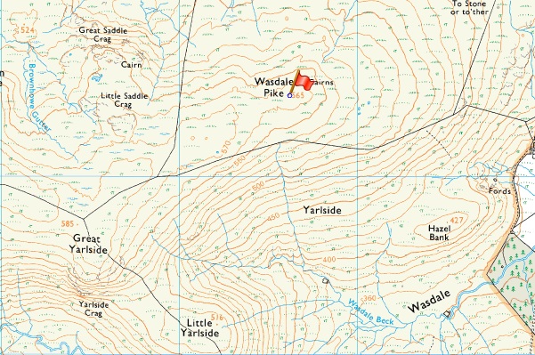
Wasdale Pike |
 |
 |
Overview |
 |
|
| Height: |
1,852 Feet 564 Metres |
| Grid Ref: |
NY 536 084 |
| Area: |
Far Eastern |
| Group: |
E/SHA |
| Ordnance Survey: |
OL7 |
| Wainwright Guidebook: |
The Outlying Fells |
| |
|
|
| |
|
Map and Photo Gallery |
|
|
|
| |
|
Walks including Wasdale Pike are:- |
|
|
Extended Wasdale Horseshoe |
|
|
 |
|
25th May 2025 |
| ASCENT: |
1,685 Feet - 513 Metres |
| MILES: |
10 |
| OUTLIERS: |
4, Whatshaw Common - Little Yarlside - Great Yarlside - Wasdale Pike |
| ROUTE: |
Shap Road Summit - Whatshaw Common - Little Yarlside - Great Yarlside - Harrop Pike - Grey Crag - Return to Great Yarlside - Wasdale Pike - Wasdale Head - Wasdale - Shap Road Summit |
|
| |
|
A Wasdale Horseshoe |
|
|
|
|
27th April 2024 |
| ASCENT: |
1'200 Feet - 366 Metres |
| MILES: |
6.2 |
| OUTLIERS: |
4, Whatshaw Common - Little Yarlside - Great Yarlside - Wasdale Pike |
| ROUTE: |
A6 Shap Road Summit - Whatshaw Common - Wasdale Mouth - Little Yarlside - Great Yarlside - Wasdale Pike - Wasdale Head Farm - A6 Shap Road Summit |
|
| |
|
Walking the Birketts, Sleddale Pike and Wasdale Pike above Wet Sleddale |
|
|
|
|
1st June 2020 |
| ASCENT: |
985 Feet - 300 Metres |
| MILES: |
10.5 |
| BIRKETTS: |
4, Sleddale Pike - Wasdale Pike - Great Saddle Crag - Ulthwaite Rigg |
| ROUTE: |
Wet Sleddale Dam - Poorhag Gill - Lunch House - Howe Gill - Gray Bull - Sleddale Pike - Great Saddle Crag - Ulthwaite Rigg - Sleddale Hall - Wet Sleddale Dam |
|
| |
|
A Wasdale Horseshoe |
|
|
|
|
7th February 2016 |
| ASCENT: |
1'200 Feet - 366 Meters |
| MILES: |
6.2 |
| OUTLIERS: |
3, Little Yarlside - Great Yarlside - Wasdale Pike |
| ROUTE: |
A6 Shap Road Summit - Whatshaw Common - Little Yarlside - Great Yarlside - Wasdale Pike - Wasdale Head Farm - A6 Shap Road Summit |
|
| |
|
Blown away on The Crookdale Horseshoe |
|
|
|
|
21st March 2014 |
| ASCENT: |
2,877 Feet – 877 Meters |
| MILES: |
9.5 |
| WAINWRIGHTS: |
N/A |
| ROUTE: |
Hause Foot – Crookdale Bridge – High House Bank – Robin Hood – Lord’s Seat – Buck Crags – Harrop Pike – Great Yarlside – Wasdale Pike – Little Yarlside – Wasdale Mouth – Whatshaw Common – Crookdale Beck – Crookdale Bridge |
|
| |
| Back to top |
 |
|