|
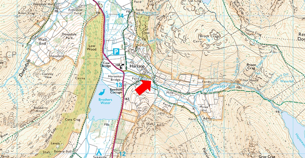
Parking Information for - Car Park, Hartsop |
 |
 |
Parking Details and Map |
 |
|
| Nearest Post Code: |
CA11 0NZ |
| Grid Reference: |
NY 410 213 |
| Notes: |
A very popular car park in the hamlet of Hartsop giving access within the heart of the east and far eastern fells just a few minutes stroll away from Brothers Water. The car park is situated at the end of a narrow lane which provides the backbone to the village. A honesty box can be found next to the gate at the far end of the car park. |
|
| |
|
Walks starting from this parking place |
|
|
|
Extended Hayeswater Circuit |
|
|
 |
|
15th October 2023 |
| ASCENT: |
3,140 Feet - 957 Metres |
| MILES: |
10.5 |
| WAINWRIGHTS: |
8, The Knott - Rampsgill Head - High Raise (Martindale) - Kidsty Pike - High Street - Mardale III Bell - Thornthwaite Crag - Gray Crag |
| ROUTE: |
Hartsop - Hayeswater Gill - Hayeswater - The Knott - Rampsgill Head - High Raise (Martindale) - Kidsty Pike - Straights of Riggindale - High Street - Mardale III Bell - Top of Hall Cove - Thornthwaite Crag - Gray Crag - Hayeswater - Hayeswater Gill - Hartsop |
|
| |
|
High Street, Thornthwaite Crag & Pasture Bottom from Hartsop |
|
|
|
|
11th April 2021 |
| ASCENT: |
2,619 Feet - 798 Metres |
| MILES: |
8 |
| WAINWRIGHTS: |
4, The Knott - High Street - Mardale III Bell - Thornthwaite Crag - |
| ROUTE: |
Hartsop - Hayeswater Gill - The Knott - Straights of Riggindale - High Street - Mardale III Bell - Top of Hall Cove - Thornthwaite Crag - Thresthwaite Mouth - Pasture Bottom - Pasture Beck - Hartsop |
|
| |
|
Hayeswater Circuit |
|
|
|
|
14th July 2020 |
| ASCENT: |
2,738 Feet - 835 Metres |
| MILES: |
8 |
| WAINWRIGHTS: |
6, The Knott, Rampsgill Head - Kidsty Pike - High Street - Thornthwaite Crag - Gray Crag |
| ROUTE: |
Hartsop - Hayeswater Gill - Hayeswater - The Knott - Rampsgill Head - Kidsty Pike - Straights of Riggindale - High Street - Thornthwaite Crag - Gray Crag - Hayeswater Gill - Hartsop |
|
| |
|
Walking the Birketts, Hartsop Horseshoe |
|
|
|
|
2nd May 2018 |
| ASCENT: |
2,812 Feet - 857 Metres |
| MILES: |
6.2 |
| BIRKETTS: |
3, Hartsop Dodd - Stony Cove Pike - Gray Crag |
| ROUTE: |
Hartsop - Hartsop Dodd - Stony Cove Pike - Threshthwaite Mouth - Thornthwaite Crag - Gray Crag - Path above Hayeswater Gill - Hartsop |
|
| |
|
Walking the Wainwrights in 30 Walks Walk 28 - A Scandale Skyline from Cow Bridge |
|
|
|
|
18th August 2016 |
| ASCENT: |
4,932 Feet - 1,504 Meters
|
| MILES: |
12.5 |
| WAINWRIGHTS: |
9, Hartsop Dodd - Caudale Moor (Stony Cove Pike) - Red Screes - Middle Dodd - Little Hart Crag - High Hartsop Dodd - Dove Crag - Hart Crag - Hartsop above How |
| ROUTE: |
Hartsop - Hartsop Dodd - Caudale Moor (Stony Cove Pike) - John Bell's Banner - St Raven's Edge - Kirkstone Pass - Red Screes - Smallthwaite Band - Middle Dodd - Top of Caiston Beck - Scandale Pass - Little Hart Crag - High Hartsop Dodd - Black Brow - Bakestones Moss - Dove Crag - Hart Crag - Hartsop above How - Gale Crag - Low Wood - Cow Bridge - Hartsop |
|
| |
|
The Harry Griffin 2,000 footers Walk 10 - Around Pasture Beck |
|
|
|
|
7th May 2015 |
| ASCENT: |
3,010 Feet - 918 Metres |
| MILES: |
7.2 |
| SUMMITS OVER 2,000Ft: |
Hartsop Dodd - Caudale Moor (Stony Cove Pike) - Thornthwaite Crag - Gray Crag South Top - Gray Crag North Top - Gray Crag North West Top |
| ROUTE: |
Hartsop - Hartsop Dodd - Mark Atkinson Monument - Caudale Moor (Stony Cove Pike) Threshthwaite Mouth - Thornthwaite Crag - Gray Crag South Top - Gray Crag North Top - Gray Crag North West Top - Hartsop Gill - Hartsop |
|
| |
|
Angletarn Pikes to Gray Crag from Hartsop |
|
|
|
|
31st January 2015 |
| ASCENT: |
2,800 Feet – 853 Meters |
| MILES: |
10.4 |
| WAINWRIGHTS: |
2,800 Feet – 853 Meters |
| ROUTE: |
Hartsop – Dubhow – Boredale Hause – Angletarn Pikes – Angle Tarn – Satura Crag – The Knott – Straights of Riggingdale – High Street – Thornthwaite Crag – Gray Crag – Hartsop |
|
| |
|
Hayeswater & Gray Crag from Hartsop |
|
|
|
|
10th May 2014 |
| ASCENT: |
2,093 Feet, 638 Meters |
| MILES: |
6.3 |
| WAINWRIGHTS: |
2, Thornthwaite Crag – Gray Crag |
| ROUTE: |
Hartsop – Wath Bridge – Hayeswater – Hayeswater Gill – Thornthwaite Crag – Gray Crag – Hartsop |
|
| |
|
The Hayeswater Fells from Hartsop |
|
|
|
|
10th November 2013 |
| ASCENT: |
2,600ft, 793 Meters |
| MILES: |
7.6 |
| WAINWRIGHTS: |
4, The Knott – High Street – Thornthwaite Crag – Gray Crag |
| ROUTE: |
Hartsop – Hayeswater – The Knott – Straights of Riggindale – High Street – Thornthwaite Crag – Gray Crag – Hayeswater – Filter House – Hartsop |
|
| |
|
One year on… |
|
|
|
|
27th October 2012 |
| ASCENT: |
3,713 Feet, 1,132 Metres |
| MILES: |
12.8 |
| WAINWRIGHTS: |
5, Place Fell – Angletarn Pikes – The Knott – High Street – Thornthwaite Crag |
| ROUTE: |
Hartsop – Dubhow – Beckstones – Crookabeck – Rooking – Side Farm – Place Fell – Round How – Steel Edge – Boredale Hause – Angletarn Pikes – Angle Tarn – Satura Crag – The Knott – Straights Of Riggindale – High Street – Thornthwaite Crag – Thresthwaite Mouth – Pasture Bottom – Pasture Beck - Hartsop |
|
| |
|
Dodging The Showers On High Street |
|
|
|
|
7th May 2011 |
| ASCENT: |
3,406 Feet, 1,038 Meters |
| MILES: |
7.7 |
| WAINWRIGHTS: |
4, The Knott, High Street, Caudale Moor & Hartsop Dodd |
| ROUTE: |
|
|
| |
|
Hartsop Dodd & Gray Crag |
|
|
|
|
24th April 2010 |
| ASCENT: |
3,012 Ft, 918 Mtrs |
| MILES: |
7 |
| WAINWRIGHTS: |
4 Hartsop Dodd, Caudale Moor (Stony Cove Pike) Thornthwaite Crag & Gray Crag |
| ROUTE: |
|
|
| |
|
High Street From Hartsop |
|
|
|
|
11th April 2008 |
| ASCENT: |
2718 Mtrs 828 Ft |
| MILES: |
xxx |
| WAINWRIGHTS: |
2 The Knott, High Street |
| ROUTE: |
xxxx |
|
| |
|
| |
| Back to top |
 |
|