|
Parking Information for - Parking Spaces, A6 Shap Road Summit |
 |
 |
Parking Details and Map |
 |
|
| Nearest Post Code: |
LA8 9LG |
| Grid Reference: |
NY 553 706 |
| Notes: |
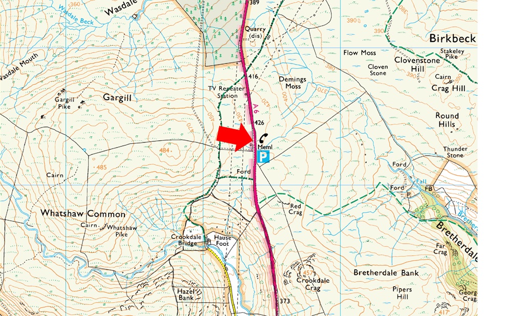
The parking spaces are found about two and half miles south of Shap village at Shap Road Summit where plaque stands in memorial to the drivers and crews who made the building of the A6 possible over Shap Fell at 1,350ft above sea level. There is room for around eight to ten well parked cars. Lookout for the Repeater Station and the many Electric Pylons which is where you will find the parking spaces. Parking is free. |
|
| |
|
Walks starting from this parking place |
|
|
|
A Wasdale Horseshoe |
|
|
 |
|
27th April 2024 |
| ASCENT: |
1'200 Feet - 366 Metres |
| MILES: |
6.2 |
| OUTLIERS: |
4, Whatshaw Common - Little Yarlside - Great Yarlside - Wasdale Pike |
| ROUTE: |
A6 Shap Road Summit - Whatshaw Common - Wasdale Mouth - Little Yarlside - Great Yarlside - Wasdale Pike - Wasdale Head Farm - A6 Shap Road Summit |
|
| |
|
A Circuit of Bretherdale from Shap Road Summit |
|
|
|
|
6th May 2023 |
| ASCENT: |
1,376 Feet - 419 Metres |
| MILES: |
8.6 |
| SUMMITS: |
6. Packhorse Hill - Clovenstone Hill - Dryside - Crag Hill - Thorny Bank - North Side |
| ROUTE: |
Shap Road Summit - Old Shap Road - Packhorse Hil - Old Shap Road - Dryside - Clovenstone Hill - Crag Hill - Round Hill - Knott Moss - Thorny Bank - North Side - Bretherdale Head - Breasthigh Beck - Breast High - Breasthigh Road - Crookdale Crag - Shap Road Summit |
|
| |
|
Harrop Pike Wild Camp |
|
|
|
|
13th August 2022 |
| ASCENT: |
2,107 Feet - 642 Metres |
| MILES: |
12.7 |
| SUMMITS: |
9, Whatshaw Common - Little Yarlside - Great Yarlside - Wasdale Pike - Harrop Pike - Grey Crag - Lord's Seat - Robin Hood - High House Bank |
| ROUTE: |
Shap Road Summit - Whatshaw Common - Little Yarlside - Great Yarlside - Wasdale Pike - Harrop Pike - CAMP - Grey Crag - Red Crag Lord's Seat - Robin Hood - High House Bank - Crookdale Beck - Whatshaw Common - Shap Road Summit |
|
| |
|
Whatshaw Common to Seat Robert |
|
|
|
|
31st July 2021 |
| ASCENT: |
2,000 Feet - 610 Metres |
| MILES: |
12.5 |
| WAINWRIGHTS: |
2, Tarn Crag (Longsleddale) - Grey Crag |
| ROUTE: |
A6 Shap Road Summit - Whatshaw Common - Little Yarlside - Great Yarlside - Harrop Pike - Grey Crag - Greycrag Tarn - Tarn Crag - Mosedale Cottage - Mosedale Beck - Scam Matthew - High Wether Howe - Seat Robert - Sleddale Hall - Wet Sleddale Reservoir |
|
| |
|
A Wasdale Horseshoe |
|
|
|
|
7th February 2016 |
| ASCENT: |
1'200 Feet - 366 Meters |
| MILES: |
6.2 |
| OUTLIERS: |
3, Little Yarlside - Great Yarlside - Wasdale Pike |
| ROUTE: |
A6 Shap Road Summit - Whatshaw Common - Little Yarlside - Great Yarlside - Wasdale Pike - Wasdale Head Farm - A6 Shap Road Summit |
|
| |
|
| |
| Back to top |
 |
|