High Rigg (Naddle Fell)

Overview
Height: 1,163 Feet - 357 Metres
Grid Ref: NY 308 218
Area: Central
Group: C/DOD
Ordnance Survey: OL4/5
Wainwright Guidebook: Three

The valley running north from Dunmail Raise, and containing Thirlmere, is suddenly confronted by a steep abrupt fell just at that final stage in its course when, with the highest hills left behind, it might reasonably be expected to go on more leisurely, as is the fashion with valleys born amongst mountains.


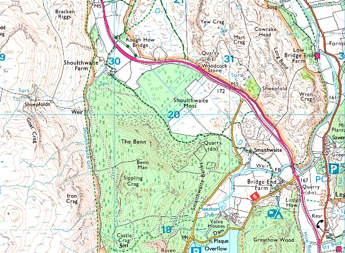
Map and Photo Gallery


High Rigg taken taken from Wren Crag.

Wainwrights High Rigg Summit at 1,171 Feet - 357 Metres


There are 8 walks to choose from including High Rigg

High Rigg & St Johns-in-the-Vale from Castlerigg Stone Circle

View this walk

23rd December 2023
ASCENT: 851 Feet - 259 Metres
MILES: 8.7
WAINWRIGHTS: High Rigg
ROUTE: Castlerigg Stone Circle - Naddle Bridge - Tewet Tarn - Low Rigg - St John's Church - St John's-in-the-Vale - Turnip Corner - Long Band - High Rigg - St John's Church - Sykes Farm - Low Nest Farm - Nest Brow - Castle Lane - Castlerigg Stone Circle
 

Walking the Birketts, Naddle fell above St John's in the Vale

View this walk

1st December 2018
ASCENT: 1,115 Feet - 340 Metres
MILES: 5
BIRKETTS: 3, Wren Crag - High Rigg - Naddle Fell
ROUTE: Legburthwaite - Smaithwaite Bridge - Wren Crag - High Rigg - Naddle Fell - St John's Church - St John's-in-the-Vale - Low Bridge End Farm - Smaithwaite Bridge - Legburthwaite
 

Walla Crag to High Rigg via Bleaberry Fell

View this walk

11th March 2017
ASCENT: 3,540 Feet - 1,079 Metres
MILES: 11.7
WAINWRIGHTS: 4, Walla Crag - Bleaberry Fell - Raven Crag - High Rigg
ROUTE: Castlerigg Stone Circle - Castle Lane - Rakefoot - Walla Crag - Bleaberry Fell - Dodd Crag - - Shoulthwaite Gill - Forestry Path - Raven Crag - Thirlmere Dam - A591 - High Rigg - Low Rigg - Naddle Bridge - Goosewell Farm - Castlerigg Stone Circle
 

Walking the Wainwrights in 30 Walks - Walk 16 A St-Johns-in-the-Vale Circuit

View this walk

5th June 2016
ASCENT: 4'243 Feet - 1'294 Meters
MILES: 12.8
WAINWRIGHTS: 6, Clough Head - Great Dodd - Watson's Dodd - Stybarrow Dodd - Raise - White Side
ROUTE: Wanthwaite - Wanthwaite Bank - Clough Head - Calfhow Pike - Great Dodd - Watson's Dodd - Stybarrow Dodd - Sticks Pass – Raise – White Side – Brund Gill– Fisherplace Gill - Above Fisher Place - Legburthwaite - Long Band - High Rigg - St John's-in-the-Vale Church - Yew Tree Farm - Wanthwaite Bridge - Wanthwaite
 

Raven Crag & Castlerigg Stone Circle


7th September 2014
ASCENT: 2,215 Feet – 675 Metres
MILES: 9.7
WAINWRIGHTS: 2,  Raven Crag – High Rigg
ROUTE: Castlerigg Stone Circle – Castle Lane – A591 – Nest Brow – Brackenrigg – Shoulthwaite – Shoulthwaite Gill – Castle Crag (fort) – Raven Crag – Thirlmere Dam – A591 – St Johns Beck – High Rigg – St Johns-in-the-Vale Church – Low Rigg – Tewit Tarn – Naddle Bridge – Goosewell Farm – Castlerigg Stone Circle
 

Latrigg, High Rigg & Walla Crag from Briar Rigg


4th January 2014
ASCENT: 3,100 Feet, 945 Meters
MILES: 14.1
WAINWRIGHTS: 3, Latrigg – High Rigg – Walla Crag
ROUTE: Briar Rigg – Spooney Green Lane – Ewe How Wood – Mallen Dodd – Latrigg – Brundholme – Railway path – across the A66 – Naddle Beck – Tewet Tarn – Low Rigg – High Rigg – Dale Bottom – Nest Brow – Castlerigg – Rakefoot – Walla Crag – Cat Gill – Derwent Water – Keswick – Briar Rigg
 

Castle Rigg Stone Circle to Raven Crag

View this walk

15th October 2011
ASCENT: 2,200 Feet, 670 Meters
MILES: 9.5
WAINWRIGHTS: 2, Raven Crag & High Rigg
ROUTE: Castle Rigg Stone Circle Castle Rigg Lane A591 Bracken Rigg Raven Crag Thirlmere Dam High Rigg Low Rigg Tewit Tarn
 

Clough Head & The Dodd’s

View this walk

8th August 2010
ASCENT: 3,553 Ft 1,083 Mtrs
MILES: 10.5
WAINWRIGHTS: 5, Clough Head, Great Dodd, Watsons Dodd, Stybarrow Dodd & High Rigg
ROUTE:  
 

Back to top