|
Sergeant Man |
 |
 |
Map and Photo Gallery |
 |
|
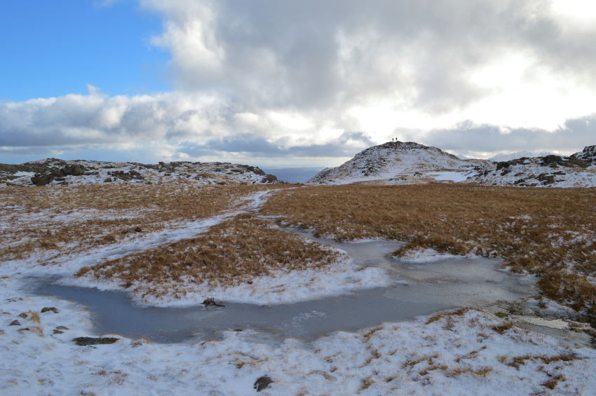 |
| Sergeant Man (right) |
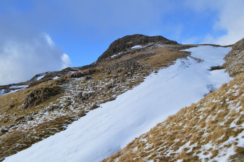 |
| Looking back on Sergeant Man during the descent towards Stickel Tarn, |
|
| |
|
There are 9 walks to choose from including Sergeant Man |
|
|
Blea Rigg to Tarn Crag from Grasmere |
|
|
 |
|
29th July 2023 |
| ASCENT: |
2,428 Feet - 740 Metres |
| MILES: |
9.2 |
| WAINWRIGHTS: |
3, Blea Rigg - Sergeant Man - Tarn Crag (Easedale) |
| ROUTE: |
A591 - Butharlyp How - Easedale Road - Goody Bridge - New Bridge - Easedale Tarn - Blea Rigg - Sergeant Man - Codale Head - Tarn Crag (Easedale) - Tarn Crag East Ridge - Far Easedale - New Bridge - Goody Bridge - Butharlyp How - A591 |
|
| |
|
The Langdale Pikes from New Dungeon Ghyll |
|
|
|
|
4th March 2023 |
| ASCENT: |
2,810 Feet - 856 Metres |
| MILES: |
7 |
| WAINWRIGHTS: |
7, Loft Crag - Pike O'Stickle - Harrison Stickle - Pavey Ark - Thunacar Knott - High Raise (Langstrath) - Sergeant Man |
| ROUTE: |
NDG - Pike How - Loft Crag - Pike O'Stickle - Harrison Combe - Harrison Stickle - Pavey Ark - Thunacar Knott - High Raise (Langstrath) - Sergeant Man - Stickle Tarn - Stickle Ghyll - NDG |
|
| |
|
Walking the Birketts, Tarn Crag East Ridge to Sergeant Man |
|
|
|
|
7th October 2018 |
| ASCENT: |
2,165 Feet - 660 Metres |
| MILES: |
7.5 |
| BIRKETTS: |
3, Tarn Crag - Codale Head - Sergeant Man |
| ROUTE: |
A591 - Grasmere - Easedale Road - Goody Bridge - Sourmilk Gill - Tarn Crag East Ridge - Tarn Crag - Codale Head - Easedale Tarn - Sourmilk Gill - Easedale Road - Grasmere - A591 |
|
| |
|
Harrison Stickle and High Raise from Great Langdale |
|
|
|
|
10th December 2016 |
| ASCENT: |
2,752 Feet - 839 Meters |
| MILES: |
6.5 |
| WAINWRIGHTS: |
4, Harrison Stickle - Thunacar Knott - Haigh Raise (Langdale) - Sergeant Man |
| ROUTE: |
Rossett Bridge - New Dungeon Ghyll - Pike Howe - Dungeon Ghyll - Harrison Stickle - Thunacar Knott - High Raise (Langdale) - Segeant Man - Stickle Tarn - Stickle Ghyll - New Dungeon Ghyll - Rossett Bridge |
|
| |
|
Walking the Wainwrights in 30 Walks, Walk 1 -A Greenburn Skyline |
|
|
|
|
16th January 2015 |
| ASCENT: |
3,150 Feet - 961 Meters |
| MILES: |
11.2 |
| WAINWRIGHTS: |
5, Helm Crag - Gibson Knott - Calg Crag - Sergeant Man - Steel Fell |
| ROUTE: |
A591 - Butharlyp Howe - Easadale Road - Helm Crag - Gibson Knott - Calf Crag - Brownrigg Moss - Mere Beck - Sergeant Man - Mere Beck - Brownrigg Moss - Steel Fell Tarn - Steel Fell - Cotra Breast - Helm Side - Low Mill Bridge - Goody Bridge - Grasmere - A591 |
|
| |
|
Around the Far Easedale Fells |
|
|
|
|
6th December 2015 |
| ASCENT: |
2,490 Feet - 760 Meters |
| MILES: |
10.3 |
| WAINWRIGHTS: |
6, Blea Rigg - Sergeant Man - High Raise (Langdale) - Calf Crag - Gibson Knott - Helm Crag |
| ROUTE: |
Grasmere - Easedale Road - Goody Bridge - New Bridge - Sourmilk Gill - Easedale Tarn - Blea Rigg - Segeant Man - High Raise (Langdale) - Mere Beck - Brownrigg Moss - Calf Crag - Gibson Knott - Helm Crag - Cotra Breast - White Crag - Brimmer Head Farm - Goody Bridge - Easedale Road - Grasmere |
|
| |
|
The Harry Griffin 2,000 footers Walk 1 -The Langdale Pikes |
|
|
|
|
21st February 2015 |
| ASCENT: |
3,540 Feet - 1,079 Meters |
| MILES: |
11 |
| SUMMITS OVER 2,000 Ft |
9,Harrison Stickle - Loft Crag - Pike O'Stickle - Thunacar Knott South Top - Thunacar Knott North Top - Pavey Ark - High Raise (Langstrath) - Ullscarth - Segeant Man |
| ROUTE: |
Stickle Barn - Pike How - Thorn Crag - Harrison Stickle - Loft Crag - Pike O'Stickle - Thunacar Knott - Pavey Ark - High Raise - Low White Stones - Greenup Edge - Ullscarth - Greenup Edge - Low White Stones - High Raise - Sergeant Man -Stickle Tarn - Stickle Ghyll - Stickle Barn |
|
| |
|
Scafell Pike from Dunmail Raise |
|
|
|
|
3rd May 2014 |
| ASCENT: |
5,800 Feet 1,768 Meters |
| MILES: |
16.8 |
| WAINWRIGHTS: |
10, Steel Fell – Calf Crag – Sergeant Man – Thunacar Knott – Pavey Ark – Harrison Stickle – Pike O’ Stickle – Rossett Pike – Great End – Scafell Pike |
| ROUTE: |
Dunmail Raise – Steel Fell – Steelfell Tarn – Calf Crag – Brownrigg Tarn – Codale Head – Sergeant Man – Thunacar Knott – Pavey Ark – Harrison Stickle – Pike O’Stickle – Martcrag Moor – Stake Pass – Rossett Pike – Angle Tarn (Langstrath) – Esk Hause – Calf Cove – Great End – Broad Crag Col – Scafell Pike – Corridor Route – Styhead – Styhead Gill – Stockley Bridge – Seathwaite |
|
| |
|
High Raise from Grasmere via Helm Crag |
|
|
|
|
7th January 2012 |
| ASCENT: |
2,800 Feet, 854 Meters |
| MILES: |
9.6 |
| WAINWRIGHTS: |
5, Helm Crag, Gibson Knott, Calf Crag, High Raise, Sergeant Man |
| ROUTE: |
Grasmere – Easedale Road – Helm Crag – Gibson Knott – Calf Crag – Brownrigg Moss – Mere Beck – High Raise – Sergeant Man – Easedale Tarn – Easedale – Grasmere |
|
| |
|
Sergeant Man & High Raise |
|
|
|
|
27th February 2010 |
| ASCENT: |
762 Mtrs 2500Ft |
| MILES: |
10 |
| WAINWRIGHTS: |
3 Blea Rigg, Sergeant Man,High Raise |
| ROUTE: |
|
|
| |
| Back to top |
 |
|