|
Wren Crag |
 |
 |
Overview |
 |
|
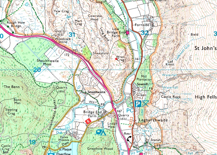
| Height: |
1020 Feet - 311 Metres |
| Grid Ref: |
NY 315 201 |
| Area: |
Central |
| Group: |
C/DOD |
| Ordnance Survey: |
OL5 |
|
| |
|
Map and Photo Gallery |
|
|
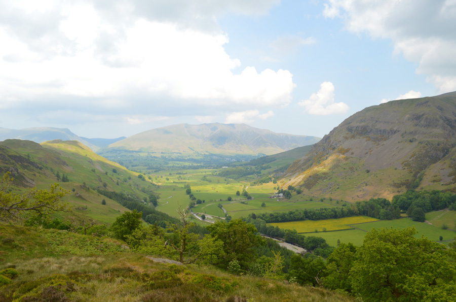 |
| St John's-in-the-Vale and Blencathra from Wren Crag summit. |
| |
|
| |
|
Walks including Wren Crag are:- |
|
|
High Rigg & St Johns-in-the-Vale from Castlerigg Stone Circle |
|
|
 |
|
23rd December 2023 |
| ASCENT: |
851 Feet - 259 Metres |
| MILES: |
8.7 |
| WAINWRIGHTS: |
High Rigg |
| ROUTE: |
Castlerigg Stone Circle - Naddle Bridge - Tewet Tarn - Low Rigg - St John's Church - St John's-in-the-Vale - Turnip Corner - Wren Crag - High Rigg - St John's Church - Sykes Farm - Low Nest Farm - Nest Brow - Castle Lane - Castlerigg Stone Circle |
|
| |
|
Walking the Birketts, Naddle fell above St John's in the Vale |
|
|
|
|
1st December 2018 |
| ASCENT: |
1,115 Feet - 340 Metres |
| MILES: |
5 |
| BIRKETTS: |
3, Wren Crag - High Rigg - Naddle Fell |
| ROUTE: |
Legburthwaite - Smaithwaite Bridge - Wren Crag - High Rigg - Naddle Fell - St John's Church - St John's-in-the-Vale - Low Bridge End Farm - Smaithwaite Bridge - Legburthwaite |
|
| |
|
Walla Crag to High Rigg via Bleaberry Fell |
|
|
|
|
11th March 2017 |
| ASCENT: |
3,540 Feet - 1,079 Metres |
| MILES: |
11.7 |
| WAINWRIGHTS: |
4, Walla Crag - Bleaberry Fell - Raven Crag - High Rigg |
| ROUTE: |
Castlerigg Stone Circle - Castle Lane - Rakefoot - Walla Crag - Bleaberry Fell - Dodd Crag - - Shoulthwaite Gill - Forestry Path - Raven Crag - Thirlmere Dam - A591 - High Rigg - Low Rigg - Naddle Bridge - Goosewell Farm - Castlerigg Stone Circle |
|
| |
|
Walking the Wainwrights in 30 Walks - Walk 16 A St-Johns-in-the-Vale Circuit |
|
|
|
|
5th June 2016 |
| ASCENT: |
4'243 Feet - 1'294 Meters
|
| MILES: |
12.8 |
| WAINWRIGHTS: |
6, Clough Head - Great Dodd - Watson's Dodd - Stybarrow Dodd - Raise - White Side |
| ROUTE: |
Wanthwaite - Wanthwaite Bank - Clough Head - Calfhow Pike - Great Dodd - Watson's Dodd - Stybarrow Dodd - Sticks Pass – Raise – White Side – Brund Gill– Fisherplace Gill - Above Fisher Place - Legburthwaite - Long Band - High Rigg - St John's-in-the-Vale Church - Yew Tree Farm - Wanthwaite Bridge - Wanthwaite |
|
| |
|
Raven Crag & Castlerigg Stone Circle |
|
|
|
|
7th September 2014 |
| ASCENT: |
2,215 Feet – 675 Metres |
| MILES: |
9.7 |
| WAINWRIGHTS: |
2, Raven Crag – High Rigg |
| ROUTE: |
Castlerigg Stone Circle – Castle Lane – A591 – Nest Brow – Brackenrigg – Shoulthwaite – Shoulthwaite Gill – Castle Crag (fort) – Raven Crag – Thirlmere Dam – A591 – St Johns Beck – High Rigg – St Johns-in-the-Vale Church – Low Rigg – Tewit Tarn – Naddle Bridge – Goosewell Farm – Castlerigg Stone Circle |
|
| |
|
Latrigg, High Rigg & Walla Crag from Briar Rigg |
|
|
|
|
4th January 2014 |
| ASCENT: |
3,100 Feet, 945 Meters |
| MILES: |
14.1 |
| WAINWRIGHTS: |
3, Latrigg – High Rigg – Walla Crag |
| ROUTE: |
Briar Rigg – Spooney Green Lane – Ewe How Wood – Mallen Dodd – Latrigg – Brundholme – Railway path – across the A66 – Naddle Beck – Tewet Tarn – Low Rigg – High Rigg – Dale Bottom – Nest Brow – Castlerigg – Rakefoot – Walla Crag – Cat Gill – Derwent Water – Keswick – Briar Rigg |
|
| |
|
Castle Rigg Stone Circle to Raven Crag |
|
|
|
|
15th October 2011 |
| ASCENT: |
2,200 Feet, 670 Meters |
| MILES: |
9.5 |
| WAINWRIGHTS: |
2, Raven Crag & High Rigg |
| ROUTE: |
Castle Rigg Stone Circle Castle Rigg Lane A591 Bracken Rigg Raven Crag Thirlmere Dam High Rigg - Low Rigg Tewit Tarn |
|
| |
|
Clough Head & The Dodd’s |
|
|
|
|
8th August 2010 |
| ASCENT: |
3,553 Ft 1,083 Mtrs |
| MILES: |
10.5 |
| WAINWRIGHTS: |
5, Clough Head, Great Dodd, Watsons Dodd, Stybarrow Dodd & High Rigg |
| ROUTE: |
|
|
| |
| Back to top |
 |
|