|
Parking Information for - Parking Spaces, Burnbanks |
 |
 |
Parking Details and Map |
 |
|
| Nearest Post Code: |
CA10 2RL |
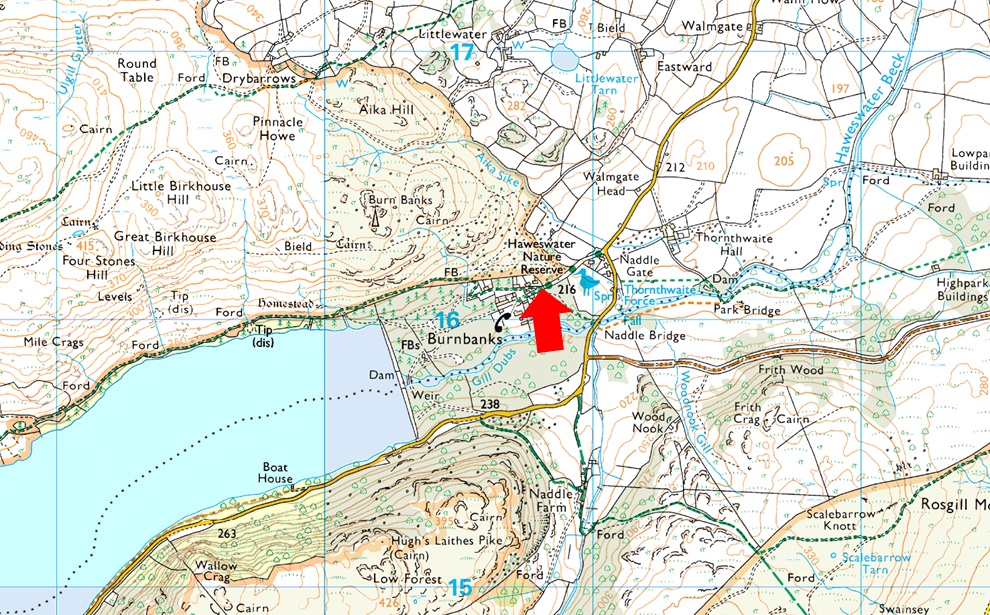
| Grid Reference: |
NY 507 716 |
| Notes: |
Burnbanks is found at the far eastern edge of Haweswater where there is a car park at the entrance to the village on the left (opposite the red phone box) with room for up to eight cars. Popular routes from the car park include Four Stones Hill, Wether Hill or even a walk around Hawsewater Reservoir. |
|
| |
|
Walks starting from this parking place |
|
|
|
A Circuit of Haweswater |
|
|
 |
|
22nd July 2023 |
| ASCENT: |
1,570 Feet - 478 Metres |
| MILES: |
10.3 |
| WAINWRIGHTS: |
N/A |
| ROUTE: |
Burnbanks - Haweswater Shore Path - Bowderthwaite Bridge - The Rigg - Mardale Head - Mardale Road - Haweswater Hotel - Naddle Bridge - Burnbanks |
|
| |
|
High Street from Burnbanks |
|
|
|
|
14th May 2022 |
| ASCENT: |
3,461 Feet - 1,055 Metres |
| MILES: |
16 |
| WAINWRIGHTS: |
5, Wether Hill - Rampsgill Head - High Street - Kidsty Pike - High Raise |
| ROUTE: |
Burnbanks - Burn Banks - Four Stones Hill - Low Kop - High Kop - Wether Hill - Red Crag - Raven Howe - High Raise (no summit) - Rampsgill Head - The Knott - Straights of Riggindale - High Street - Straights of Riggindale - Kidsty Pike - High Raise - Low Raise - Long Grain - Measand End - Pultsgill Sike - Measand Beck - Haweswater Shore Path - Burnbanks |
|
| |
|
Walking the Birketts, Bampton Fell above Haweswater |
|
|
|
|
7th April 2018 |
| ASCENT: |
1,096 Feet - 334 Metres |
| MILES: |
4.8 |
| BIRKETTS: |
Pinnacle Howe - Four Stones Hill - Bampton Fell |
| ROUTE: |
Burnbanks - Pinnacle Howe - Birkhouse Hill - Four Stones Hill - Bamptone Fell - Measand Beck - Burnbanks |
|
| |
|
Four Stone Hill to High Raise from Burnbanks |
|
|
|
|
8th May 2014 |
| ASCENT: |
2,800 Feet, 854 Meters |
| MILES: |
11 |
| WAINWRIGHTS: |
2, Wether Hill – High Raise (Martindale) |
| ROUTE: |
Burnbanks – Four Stones Hill – Low Kop – High Kop – Wether Hill – Red Crag – Red Crag Tarn – Raven Howe – High Raise (Martindale) – Low Raise – Long Grain – Measand End – Measand Beck – The Forces (Waterfall) – Haweswater – Burnbanks |
|
| |
|
| |
| Back to top |
 |
|