 |
Wether Hill |
 |
 |
Map and Photo Gallery |
 |
|
 |
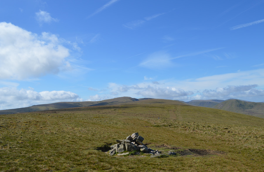
| Wether Hill from the Lowther Chimney/Loadpot Hill. |
 |
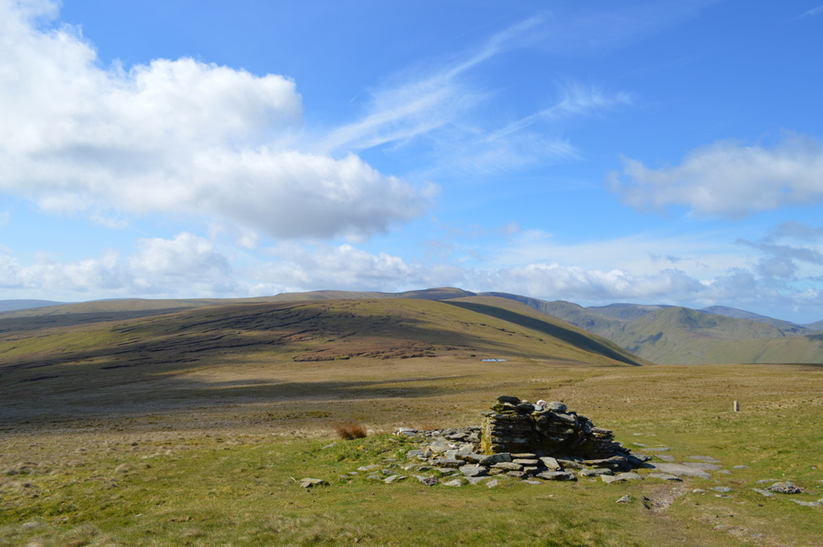
| Red Crag and a distant High Raise (Martindale) from Wether Hill summit cairn. |
|
| |
|
There are 13 walks to choose from including Wether Hill |
|
|
Mardale Head to Cawdale |
|
|
 |
|
21st June 2025 |
| ASCENT: |
2,708 Feet - 825 Metres |
| MILES: |
11 |
| WAINWRIGHTS: |
6, High Street - The Knott - Rampsgill Head - Kidsty Pike - High Raise (Martindale) - Wether Hill |
| ROUTE: |
Mardale Head - The Rigg - Rough Crag - Caspel Gate - Long Stile - High Street - Straights of Riggindale - The Knott - Rampsgill Head - High Raise (Martindale) Raven Howe - Red Crag - Wether Hill - High Kop - Low Kop - The Hause - Hause End - Cawdale |
|
| |
|
High Street from Burnbanks |
|
|
|
|
14th May 2022 |
| ASCENT: |
3,461 Feet - 1,055 Metres |
| MILES: |
16 |
| WAINWRIGHTS: |
5, Wether Hill - Rampsgill Head - High Street - Kidsty Pike - High Raise |
| ROUTE: |
Burnbanks - Burn Banks - Four Stones Hill - Low Kop - High Kop - Wether Hill - Red Crag - Raven Howe - High Raise (no summit) - Rampsgill Head - The Knott - Straights of Riggindale - High Street - Straights of Riggindale - Kidsty Pike - High Raise - Low Raise - Long Grain - Measand End - Pultsgill Sike - Measand Beck - Haweswater Shore Path - Burnbanks |
|
| |
|
A Fusedale Circuit |
|
|
|
|
27th February 2022 |
| ASCENT: |
2,151 Feet - 656 Metres |
| MILES: |
7 |
| WAINWRIGHTS: |
4, Bonscale Pike - Loadpot Hill - Wether Hill - Steel Knotts (Pikeawassa) |
| ROUTE: |
Martindale New Church - The Coombs - Mellgaurds - Bonscale Pike - Loadpot Hill - Wether Hill - Mere Beck - Gowk Hill - Brownthwaite Crags - Steel Knotts (Pikeawassa) - Birkie Knott - Lanty Tarn - Martindale New Church |
|
| |
|
Loadpot Hill Wild Camp |
|
|
|
|
12th - 13th June 2021 |
| ASCENT: |
2,880 Feet - 878 Metres |
| MILES: |
15.9 |
| WAINWRIGHTS: |
4, Arthur's Pike - Bonscale Pike - Loadpot Hill - Wether Hill |
| ROUTE: |
Askham – Askham Fell - The Cockpit - Barton Fell - Arthur’s Pike – Swarth Beck - Boncale Pike – Loadpot Hill CAMP – Wether hill – Gowk Hill - Fusedale - Mellguards – Path Below Bonscale Pike – The Cockpit - Heughscar Hill – Askham |
|
| |
|
Steel Knotts, Wether Hill and Fusedale |
|
|
|
|
14th March 2020 |
| ASCENT: |
2,207 Feet - 673 Metres |
| MILES: |
6.1 |
| WAINWRIGHTS: |
3, Steel Knotts (Pikeawassa) - Wether Hill - Hallin Fell |
| ROUTE: |
Martindale New Church - Birkie Knott - Steel Knotts (Pikeawassa) - Brownthwaite Crag - Gawk Hill - Wether Hill - Groove Gill - Fusedale - Fusedale Beck - The Coombs - Martindale New Church - Hallin Fell - Martindale New Church |
|
| |
|
Walking the Birketts, Around The Cawdale Horseshoe to Loadpot Hill |
|
|
|
|
25th February 2019 |
| ASCENT: |
1,571 Feet - 479 Metres |
| MILES: |
9 |
| BIRKETTS: |
4, Low Kop - Red Crag - Wether Hill - Loadpot Hill |
| ROUTE: |
Mooreahill Farm - Cawdale Beck - Low Kop - High Kop - Red Crag - Wether Hill - Loadpot Hill - Hart Hill - The Pen - Pen End - Moorahill Farm |
|
| |
|
Walking the Wainwrights in 30 Walks - Walk 20 Fourteen Fells east of Ullswater |
|
|
|
|
3rd July 2016 |
| ASCENT: |
4,790 Feet - 1,460 Meters |
| MILES: |
19.9 |
| WAINWRIGHTS: |
14, Bonscale Fell - Arthurs Pike - Loadpot Hill - Wether Hill - High Raise (Martindale) - Kidsty Pike - Rampsgill Head - High Street - The Knott - Rest Dodd - The Nab - Brock Crags - Angletarn Pikes - Beda Fell |
| ROUTE: |
Martindale New Church - Mellgaurds - Bonscale Pike - Top of Swarth Beck - Arthurs Pike - Loadpot Hill - Wether Hill - Red Crag - High Raise (Martindale) - Rampsgill Head - Kidsty Pike - Straights of Riggindale - High Street - Straights of Riggindale - The Knott - Rest Dodd - The Nab - Satura Crag - Brock Crags - Angletarn Pikes - Heckbeck Head - Beda Knott - Beda Fell - Winter Crag - Martindale Old Church - Martindale New Church |
|
| |
|
The Harry Griffin 2,000 footers Walk 14 -Walking High Street |
|
|
|
|
23rd May 2015 |
| ASCENT: |
3,864 Feet - 1,178 Metres |
| MILES: |
12 |
| SUMMITS OVER 2,000 Ft: |
Loadpot Hill - Wether Hill (NY 456 167) Wether Hill (NY 455 163) - Red Crag - Raven Howe - High Raise - Kidsty Pike - Rampsgill Head - The Knott - Rest Dodd - High Street - Rough Crag |
| ROUTE: |
Martindale New Church - Howtown - Fusedale - Brock Crag - Loadpot Hill - Wether Hill - Red Crag - Raven How - High Raise - Kidsty Pike - Rampsgill Head - The Knott - Straights of Riggindale - High Street - Rough Crag - Mardale Head |
|
| |
|
Four Stone Hill to High Raise from Burnbanks |
|
|
|
|
8th May 2014 |
| ASCENT: |
2,800 Feet, 854 Meters |
| MILES: |
11 |
| WAINWRIGHTS: |
2, Wether Hill – High Raise (Martindale) |
| ROUTE: |
Burnbanks – Four Stones Hill – Low Kop – High Kop – Wether Hill – Red Crag – Red Crag Tarn – Raven Howe – High Raise (Martindale) – Low Raise – Long Grain – Measand End – Measand Beck – The Forces (Waterfall) – Haweswater – Burnbanks |
|
| |
|
Loadpot Hill via Heltondale |
|
|
|
|
19th January 2014 |
| ASCENT: |
1,969 Feet, 600 Meters |
| MILES: |
13.2 |
| WAINWRIGHTS: |
4 Wether Hill – Loadpot Hill – Bonscale Pike – Arthurs Pike |
| ROUTE: |
Roehead – Moor Divock – Heltondale – Scales Farm – Heltondale Beck – Kid Moor – The Pen – Hart Hill – Wether Hill – Loadpot Hill – Bonscale Pike – Arthurs Pike – Barton Fell – The Cockpit Stone Circle – Roehead |
|
| |
|
The Martindale Horseshoe |
|
|
|
|
19th May 2013 |
| ASCENT: |
4,007 Feet, 1,221 Metres |
| MILES: |
12 |
| WAINWRIGHTS: |
9, Beda Fell – Angletarn Pikes – Brock Crags – Rest Dodd – The Knott – Rampsgill Head – High Raise – Wether Hill – Steel Knotts (Pikeawassa) |
| ROUTE: |
Martindale New Church – Martindale Old Church – Winter Crag – Beda Fell – Bedafell Knott – Angletarn Pikes – Brock Crags – Satura Crag – Rest Dodd – The Knott – Rampsgill Head – High Raise – Raven Howe – Red Crag – High Street Roman Road (Course Of) – Wether Hill – Brownthwaite Crag – Steel Knotts (Pikeawassa) – Birkie Knott – Lanty Tarn – Martindale New Church |
|
| |
|
The High Street Roman Road - 'Brocavvm to Galava' |
|
|
|
|
30th June 2012 |
| ASCENT: |
4’000 Feet, 1,219 Metres |
| MILES: |
5, Wether Hill, High Raise, Rampsgill Head, High Street & Thornthwaite Crag |
| WAINWRIGHTS: |
25.1 |
| ROUTE: |
Brougham Castle – BROCAVVM ROMAN FORT (Penrith) – Brougham Hall – Eamont Bridge – Yanwath – Tirril – Celleron -Winder Hall Farm – Moor Divock – Lambert Lad – Loadpot Hill – Wether Hill – Red Crag (High Street) – Raven Howe – High Raise (Martindale) – Rampsgill Head – Two Penny Crag -Straits of Riggindale – High Street – Thornthwaite Crag – Thornthwaite Beacon – Park Fell – Hagg Gill – Troutbeck Park – Ing Lane – Troutbeck – Truss Lane – A592 – Robin Lane – Jenkin Crag – High Skelghyll – Skelghyll Wood – A591 – A5075 – GALAVA ROMAN FORT (Ambleside) |
|
| |
|
The Fusedale Circuit |
|
|
|
|
26th September 2010 |
| ASCENT: |
3,287 Ft 1,002 Mtrs |
| MILES: |
9 |
| WAINWRIGHTS: |
6 Hallin Fell, Steel Knott’s (Pikeawassa), Wetherhill, Loadpot Hill, Arthurs Pike, Bonscale Pike |
| ROUTE: |
|
|
| |
| Back to top |
 |
|

