 |
Cofa Pike |
 |
 |
Overview |
 |
|
| Height: |
2,700 Feet - 823 Metres |
| Grid Ref: |
NY 358 120 |
| Area: |
Eastern |
| Group: |
C/FAR |
| Ordnance Survey: |
OL5 |
|
| |
|
Map and Photo Gallery |
|
|
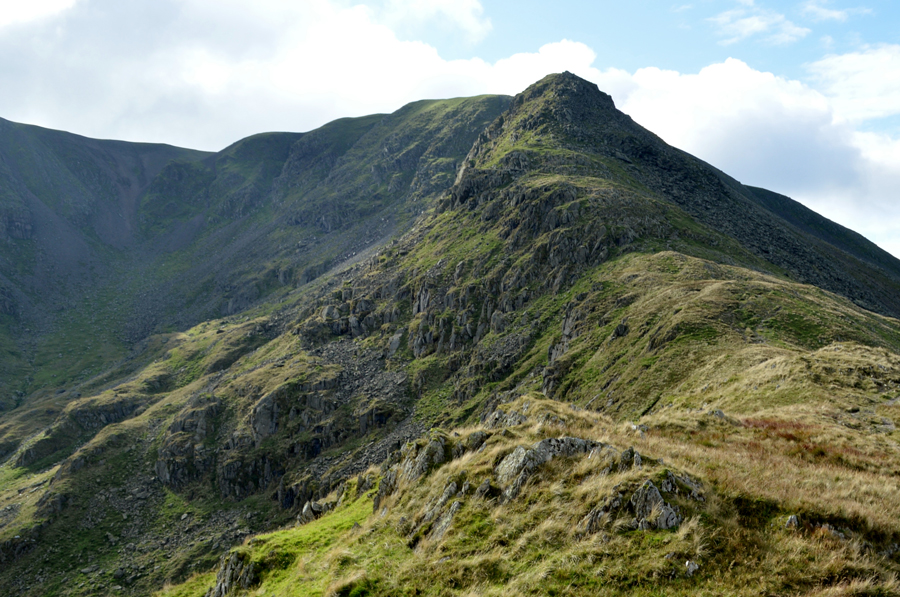 |
| Cofa Pike from Deepdale Hause. |
| |
|
| |
|
Walks including Cofa Pike are:- |
|
|
Fairfield from Patterdale |
|
|
 |
|
14th February 2026 |
| ASCENT: |
3,256 Feet - 992 Metres |
| MILES: |
9.5 |
| WAINWRIGHTS: |
4, Arnison Crag - Birks - St Sunday Crag - Fairfield |
| ROUTE: |
Patterdale - Arnison Crag - Trough Head - Birks - St Sunday Crag - Deepdale Hause - Cofa Pike - Fairfield - Hause Gap - Grisedale Tarn - Grisedale - Ruthwaite Lodge - Elmhow - Patterdale |
|
| |
|
St Sunday Crag & Fairfield from Patterdale |
|
|
|
|
18th January 2025 |
| ASCENT: |
3,255 Feet - 992 Metres |
| MILES: |
9 |
| WAINWRIGHTS: |
3, Birks - St Sunday Crag - Fairfield |
| ROUTE: |
Patterdale - Grisedale - Thornhow End - Birks - St Sunday Crag - Deepdale Hause - Cofa Pike - Fairfield - Hause Gap - Grisedale Tarn - Grisedale - Ruthwaite Lodge - Elmhow - Patterdale |
|
| |
|
Fairfield via Cawk Cove |
|
|
|
|
21st July 2024 |
| ASCENT: |
2,680 Feet - 817 Metres |
| MILES: |
7.5 |
| WAINWRIGHTS: |
3, Fairfield - Hart Crag - Hartsop above How |
| ROUTE: |
Deepdale Bridge - Deepdale Hall - Wall End - Deepdale - Deepdale Beck - Mossydale - Cawk Cove - Cofa Pike - Fairfield - Link Hause - Hart Crag - Hartsop above How - Gale Crag - Deepdale Bridge |
|
| |
|
Fairfield via The Step |
|
|
|
|
13th October 2022 |
| ASCENT: |
3,015 Feet - 919 Metres |
| MILES: |
8 |
| WAINWRIGHTS: |
2, Fairfield - St Sunday Crag |
| ROUTE: |
Deepdale Bridge – Wallend – Deepdale – Mossydale – Link Cove – The Step – Link Hause - Fairfield – Cofa Pike – Deepdale Hause - St Sunday Crag - Gavel Pike - Lord's Seat - Coldcove Gill - Deepdale - Deepdale Bridge |
|
| |
|
The Deepdale Horseshoe |
|
|
|
|
1st August 2020 |
| ASCENT: |
3,267 Feet - 997 Metres |
| MILES: |
7.5 |
| WAINWRIGHTS: |
4, Hartsop above Howe - Hart Crag - Fairfield - St Sunday Crag |
| ROUTE: |
Deepdale Bridge - Gale Crag - Hartsop above Howe - Hart Crag - Link Hause - Fairfield - Cofa Pike - St Sunday Crag - Gavel Pike - Lords Seat - Deepdale - Deepdale Bridge |
|
| |
|
Walking the Birketts, Deepdale Horseshoe |
|
|
|
|
14th April 2018 |
| ASCENT: |
3,521 Feet - 1,073 Metres |
| MILES: |
9.5 |
| BIRKETTS: |
9, Arnison Crag - Birks - Gavel Pike - St Sunday Crag - Cofa Pike - Fairfield - Hart Crag - Giil Crag (Hartsop above How) - Gale Crag |
| ROUTE: |
Patterdale - Oxford Crag - Arnison Crag - Trough Head - Birks - Gavel Pike - St Sunday Crag - Deepdale Hause - Cofa Pike - Fairfield - Link Hause - Hart Crag - Giil Crag (Hartsop above How) - Gale Crag - Deepdale Bridge - Patterdale |
|
| |
|
Fairfield via Deepdale and The Step |
|
|
|
|
15th April 2017 |
| ASCENT: |
3,627 Feet - 1,106 Metres |
| MILES: |
10 |
| WAINWRIGHTS: |
3, Fairfield - St Sunday Crag - Birks |
| ROUTE: |
Deepdale Bridge – Wallend – Deepdale – Mossydale – Link Cove – The Step – Link Hause - Fairfield – Cofa Pike – St Sunday Crag – Birks – Thornhow End – Patterdale – Rooking – Deepdale Bridge |
|
| |
|
A Deepdale Horseshoe |
|
|
|
|
8th October 2016 |
| ASCENT: |
3,448 Feet - 1,051 Meters |
| MILES: |
10.2 |
| WAINWRIGHTS: |
6, Arnison Crag - Birks - St Sunday Crag - Fairfield - Hart Crag - Hartsop above How |
| ROUTE: |
Patterdale - Arnison Crag - Trough Head - Birks - St Sunday Crag - Deepdale Hause - Cofa Pike - Fairfield - Hart Crag - Hartsop Above How - Deepdale Bridge - A592 – Patterdale |
|
| |
|
A Grisedale Horseshoe via Striding Edge |
|
|
|
|
13th September 2013 |
| ASCENT: |
4,934 Feet – 1,540 Meters |
| MILES: |
11.8 |
| WAINWRIGHTS: |
8, Helvellyn – Nethermost Pike – Dollywagon Pike – Seat Sandal – Fairfield – St Sunday Crag – Birks – Arnison Crag |
| ROUTE: |
Patterdale – Grisedale – Striding Edge – Helvellyn – Nethermost Pike – High Crag – Dollywagon Pike – Grisedale Tarn – Seat Sandal – Grisedale Hause – Fairfield – Cofa Pike – Deepdale Hause – St Sunday Crag – Birks – Trough Head – Arnison Crag – Oxford Crag – Patterdale |
|
| |
|
The Deepdale Horseshoe |
|
|
|
|
8th September 2013 |
| ASCENT: |
3,450 Ft, 1,052 Meters |
| MILES: |
10.2 |
| WAINWRIGHTS: |
5, Birks – St Sunday Crag – Fairfield – Hart Crag – Hartsop Above How |
| ROUTE: |
Bridgend – A592 – Glenamara Park – Thornhow End – Birks – St Sunday Crag – Deepdale Hause – Cofa Pike – Fairfield – Link Hause – Hart Crag – Hartsop Above How – Gale Crag – Bridgend |
|
| |
|
St Sunday Crag |
|
|
|
|
18th April 2010 |
| ASCENT: |
873 Mtrs 2,863 Ft |
| MILES: |
9.9 |
| WAINWRIGHTS: |
4, Seat Sandal, Fairfield, St Sunday Crag, Birks |
| ROUTE: |
|
|
| |
| Back to top |
 |
|
