|
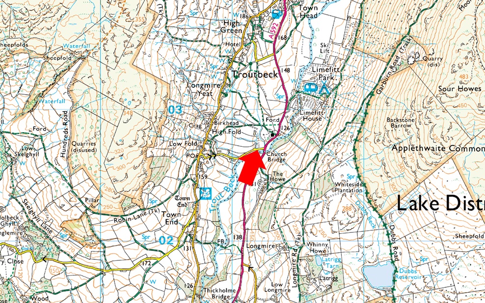
Parking Information for - Parking Spaces, Church Bridge, Troutbeck |
 |
 |
Parking Details and Map |
 |
|
| Nearest Post Code: |
LA23 1PE |
| Grid Reference: |
NY 412 202 |
| Notes: |
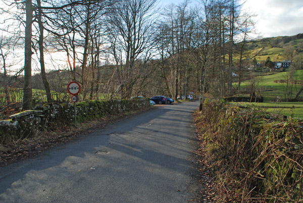
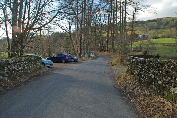
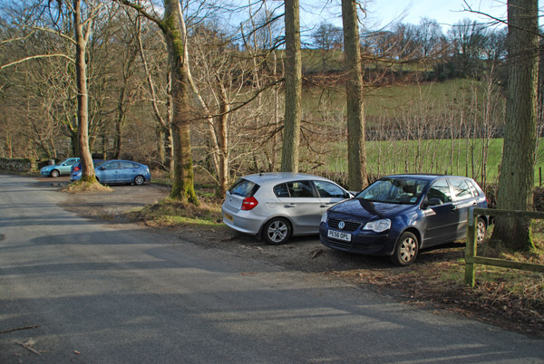
The parking spaces at Church Bridge can be found between Jesus Church and Church Bridge, if travelling from the A592 the car park will appear on the left immediately after crossing Church Bridge. This is a small car park popular with walks around Troutbeck or the higher fells of the III Bell ridge meaning availability can be tight during peak seasons. Parking is free. |
|
| |
|
Photos |
|
|
|
| |
|
Walks starting from this parking place |
|
|
|
High Street via The Ill Bell Ridge |
|
|
 |
|
3rd January 2026 |
| ASCENT: |
3,334 Feet - 1,016 Metres |
| MILES: |
12.8 |
| TORS VISITED: |
5, Yoke - III Bell - Froswick - High Street - Thornthwaite Crag |
| ROUTE: |
Church Bridge - Garburn Pass - Top of Garburn Pass - Yoke - III Bell - Froswick - High Street - Thornthwaite Crag - Scot Rake - Hagg Gill - Hagg Bridge - Ing Bridge - Ing Lane - Truss Lane - A592 - Troutbeck - Jesus Church - Church Bridge |
|
| |
|
Stony Cove Pike via Doup Crag, Troutbeck |
|
|
|
|
2nd June 2025 |
| ASCENT: |
2,820 Feet - 860 Metres |
| MILES: |
10.1 |
| WAINWRIGHTS: |
Caudale Moor |
| ROUTE: |
Church Bridge, Troutbeck - Limefit Holiday Park - Troutbeck - Long Green Head - Ing Lane - Troutbeck Park Farm - Trout Beck - Low Great Knott - High Great Knott - Sad Gill - Doup Crag - Caudale Moor - Stony Cove Pike - Thresthwaite Mouth - Park Fell Head - Trout Beck - Troutbeck Park Farm - Hagg Bridge - Ing Bridge - Ing Lane - Truss Lane - Permissive Path to Limefit Holiday Park - Church Bridge, Troutbeck |
|
| |
|
High Street via The Ill Bell Ridge |
|
|
|
|
18th November 2024 |
| ASCENT: |
3,616 Feet - 1,102 Metres |
| MILES: |
13.2 |
| TORS VISITED: |
6, Yoke - III Bell - Froswick - High Street - Thornthwaite Crag - Troutbeck Tongue |
| ROUTE: |
Church Bridge - Garburn Pass - Top of Garburn Pass - Yoke - III Bell - Froswick - High Street - Thornthwaite Crag - Scot Rake - Hagg Gill - Troutbeck Tongue - Hagg Bridge - Ing Bridge - Ing Lane - Truss Lane - A592 - Troutbeck - Jesus Church - Church Bridge |
|
| |
|
High Level Circuit of Troutbeck |
|
|
|
|
10th August 2023 |
| ASCENT: |
4,251 Feet - 1,296 Metres |
| MILES: |
14 |
| WAINWRIGHTS: |
5, Yoke - III Bell - Froswick - Thornthwaite Crag - Caudale Moor |
| ROUTE: |
Church Bridge - Garburn Road - Top of Garburn Pass - Yoke - III Bell - Froswick - Thornthwaite Crag - Threshthwaite Mouth - Stony Cove Pike - Caudale Moor - John Bell's Banner - St Raven's Edge - Broad End - Kirkstone Pass - Idle Hill - Baystones - Nanny Lane - Troutbeck - Church Bridge |
|
| |
|
High Street via The Ill Bell Ridge from Troutbeck Bridge |
|
|
|
|
5th August 2017 |
| ASCENT: |
3,817 Feet - 1,164 Metres |
| MILES: |
14 |
| WAINWRIGHTS: |
5, Yoke - Ill Bell - Froswick - Mardale III Bell - High Street |
| ROUTE: |
Church Bridge - Garburn Pass - Garburn Nook - Yoke - Ill Bell - Froswick - Top of Hall Cove - Mardale III Bell - High Street - Thornthwaite Crag - Scot Rake - Hagg Gill - Hagg Bridge - Ing Bridge - Ing Lane - Truss Lane - A591 - Troutbeck - Jesus Church - Church Bridge |
|
| |
|
Before the rain came, Sallows and Sour Howes from Church Bridge |
|
|
|
|
24th September 2016 |
| ASCENT: |
1,935 Feet - 591 Meters |
| MILES: |
7.7 |
| WAINWRIGHTS: |
2, Sallows - Sour Howes |
| ROUTE: |
Church Bridge - Jesus Church - The Howe - Garburn Pass - Garburn Nook - Sallows - Wardles - Capple Howe- Sour Howes - Backstone Barrow - Dubbs Road - Dubbs Reservoir - Moorhowe Road - Longmire Road - The Howe - Jesus Church - Church Bridge |
|
| |
|
Walking the Wainwrights in 30 Walks - Walk 10 A Troutbeck Circuit |
|
|
|
|
16th April 2016 |
| ASCENT: |
4,406 Feet - 1,344 Meters |
| MILES: |
15 |
| WAINWRIGHTS: |
9, Sour Howes - Sallows - Yoke - III Bell - Froswick - Thornthwaite Crag - Gray Crag - Troutbeck Tongue - Wansfell |
| ROUTE: |
Church Bridge - Garburn Pass - Sour Howes - Sallows - Yoke - III Bell - Froswick - Thornthwaite Crag - Gray Crag - Thornthwaite Crag - Scot Rake - Troutbeck Tounge - Trout Beck - Kirkstone Pass - Iddle Hill - Baystones - Wansfell Pike - Nanny Lane - Troutbeck - Church Bridge |
|
| |
|
A Troutbeck Wander |
|
|
|
|
24th January 2016 |
| ASCENT: |
1,181 Feet - 361 Meters |
| MILES: |
7.6 |
| WAINWRIGHTS: |
Troutbeck Tongue |
| ROUTE: |
Church Bridge - Troutbeck Church - Kirkstone Pass - Limefitt Park - Troutbeck - Long Green Head Farm - Hagg Gill - Troutbeck Tongue - Hagg Bridge - Ing Bridge - Ing Lane - Truss Lane - Troutbeck Church - Church Bridge |
|
| |
|
Ill Bell North East Ridge from Troutbeck |
|
|
|
|
31st May 2013 |
| ASCENT: |
4,000 Feet |
| MILES: |
13 |
| WAINWRIGHTS: |
2, Ill Bell – Froswick |
| ROUTE: |
Church Bridge – Garburn Pass – The Nook – Scales – Hartrigg – Kentmere Reservoir – Ill Bell North East Ridge – Ill Bell – Froswick – Scot Rake – Troutbeck Park – Hag Gill – Ing Bridge – Ing Lane – Truss Lane – Troutbeck – Church Bridge |
|
| |
|
Thornthwaite Crag via the Ill Bell Ridge |
|
|
|
|
10th December 2011 |
| ASCENT: |
3,780 Feet, 1,152 Meters |
| MILES: |
11.6 |
| WAINWRIGHTS: |
7, Sour Howes, Sallows, Yoke, Ill Bell, Froswick, Thornthwaite Crag, Troutbeck Tongue |
| ROUTE: |
Troutbeck Church – Garburn Road – Sour Howes – Garburn Nook – Garburn Pass – Yoke – Ill Bell – Froswick – Thresthwaite Mouth – Troutbeck Tongue – Ings Lane – Truss Lane – Troutbeck Church |
|
| |
|
Making it up as I go along in Troutbeck |
|
|
|
|
2nd September 2011 |
| ASCENT: |
2,824 Feet, 861 Meters |
| MILES: |
12.9 |
| WAINWRIGHTS: |
4, Sour Howes, Sallows, Troutbeck Tongue & Wansfell Pike |
| ROUTE: |
|
|
| |
|
| |
| Back to top |
 |
|