 |
Great Rigg |
 |
 |
Map and Photo Gallery |
 |
|
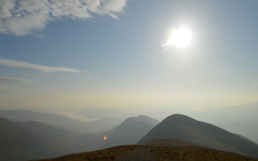 |
| Windermere & Heron Pike from Great Rigg |
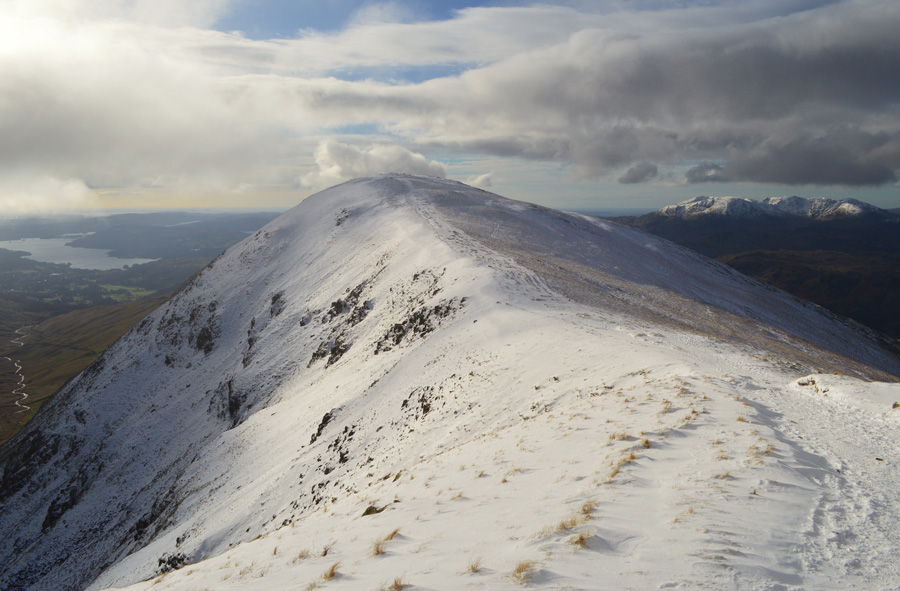 |
| Great Rigg shortly after leaving Fairfield |
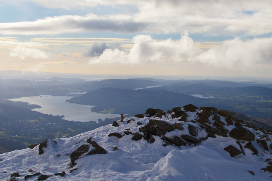 |
| Windermere from Great Rigg summit cairn |
|
| |
|
There are 22 walks to choose from including Great Rigg |
|
|
Fairfield from Grasmere |
|
|
 |
|
21st September 2025 |
| ASCENT: |
2,694 Feet - 821 Metres |
| MILES: |
6.2 |
| WAINWRIGHTS: |
3, Stone Arthur - Great Rigg - Fairfield |
| AVERAGE PACE: |
A591 - Greenhead Gill - Stone Arthur - Great Rigg - Fairfield - Grisedale Hause - Hause Gap - Hause Moss - Tongue Gill - A591 |
|
| |
|
The Fairfield Horseshoe |
|
|
|
|
13th March 2025 |
| ASCENT: |
3,356 Feet - 1,024 Metres |
| MILES: |
10 |
| WAINWRIGHTS: |
8, Nab Scar - Heron Pike - Great Rigg - Fairfield - Hart Crag - Dove Crag - High Pike - Low Pike |
| ROUTE: |
Rydal Church - Rydal Mount - Nab Scar - Heron Pike - Erne Crag - Rydal Fell - Great Rigg - Fairfield - Link Hause - Hart Crag - Dove Crag - High Pike - Low Pike - Low Sweden Bridge - Rydal Park - Rydal Mount - Rydal Church |
|
| |
|
Fairfield from Grasmere |
|
|
|
|
28th September 2024 |
| ASCENT: |
2,694 Feet - 821 Metres |
| MILES: |
6.2 |
| WAINWRIGHTS: |
3, Stone Arthur - Great Rigg - Fairfield |
| AVERAGE PACE: |
A591 - Greenhead Gill - Stone Arthur - Great Rigg - Fairfield - Grisedale Hause - Hause Gap - Hause Moss - Tongue Gill - A591 |
|
| |
|
Nab Scar to Stone Arthur from Rydal |
|
|
|
|
24th February 2024 |
| ASCENT: |
2,424 Feet - 739 Metres |
| MILES: |
6.5 |
| WAINWRIGHTS: |
4, Nab Scar - Heron Pike - Great Rigg - Stone Arthur |
| ROUTE: |
Rydal Mount - Nab Scar - Heron Pike - Erne Crag - Rydal Fell - Great Rigg - Stone Arthur - Greenhead Gill - A591 - Grasmere - A591 |
|
| |
|
Boxing Day on Fairfield |
|
|
|
|
26th December 2023 |
| ASCENT: |
2,694 Feet - 821 Metres |
| MILES: |
6.2 |
| WAINWRIGHTS: |
3, Stone Arthur - Great Rigg - Fairfield |
| AVERAGE PACE: |
A591 - Greenhead Gill - Stone Arthur - Great Rigg - Fairfield - Grisedale Hause - Hause Gap - Hause Moss - Tongue Gill - A591 |
|
| |
|
Fairfield & Seat Sandal from Grasmere |
|
|
|
|
17th June 2023 |
| ASCENT: |
3,176 Feet - 968 Metres |
| MILES: |
6.2 |
| WAINWRIGHTS: |
4, Stone Arthur - Great Rigg - Fairfield - Seat Sandal |
| AVERAGE PACE: |
A591 - Greenhead Gill - Stone Arthur - Great Rigg - Fairfield - Grisedale Hause - Seat Sandal - Seat Sandal South Ridge - Tongue Gill - Mill Bridge - A591 |
|
| |
|
Fairfield & Seat Sandal from Grasmere |
|
|
|
|
2nd October 2022 |
| ASCENT: |
3,176 Feet - 968 Metres |
| MILES: |
6.2 |
| WAINWRIGHTS: |
4, Stone Arthur - Great Rigg - Fairfield - Seat Sandal |
| ROUTE: |
A591 - Greenhead Gill - Stone Arthur - Great Rigg - Fairfield - Grisedale Hause - Seat Sandal - Seat Sandal South Ridge - Tongue Gill - Mill Bridge - A591 |
|
| |
|
The Fairfield Horseshoe |
|
|
|
|
24th February 2024 |
| ASCENT: |
3,356 Feet - 1,024 Metres |
| MILES: |
10 |
| WAINWRIGHTS: |
8, Nab Scar - Heron Pike - Great Rigg - Fairfield - Hart Crag - Dove Crag - High Pike - Low Pike |
| ROUTE: |
Pelter Bridge - A591 - Rydal Mount - Nab Scar - Heron Pike - Rydal Fell - Great Rigg - Fairfield - Link Hause - Hart Crag - Dove Crag - High Pike - Low Pike - Low Sweden Bridge - Rydal Park - Rydal Mount - A591 - Pelter Bridge |
|
| |
|
Fairfield & Seat Sandal from Grasmere |
|
|
|
|
10th October 2021 |
| ASCENT: |
3,176 Feet - 968 Metres |
| MILES: |
6.2 |
| WAINWRIGHTS: |
4, Stone Arthur - Great Rigg - Fairfield - Seat Sandal |
| ROUTE: |
A591 - Greenhead Gill - Stone Arthur - Great Rigg - Fairfield - Grisedale Hause - Seat Sandal - Seat Sandal South Ridge - Tongue Gill - Mill Bridge - A591 |
|
| |
|
Almost Fairfield from Grasmere |
|
|
|
|
10th October 2020 |
| ASCENT: |
2,947 Feet - 899 Metres |
| MILES: |
6.5 |
| WAINWRIGHTS: |
2, Stone Arthur - Great Rigg |
| ROUTE: |
A591 - Michael's Nook - Greenhead Gill - Stone Arthur - Great Rigg - Fairfield (almost) - Great Rigg - Grains Gill - Rowantree Gill - Alcock Tarn - Michael's Nook - A591 |
|
| |
|
Walking the Birketts, Over Seat Sandal to Fairfield |
|
|
|
|
14th October 2018 |
| ASCENT: |
2,862 Feet - 873 Metres |
| MILES: |
6.2 |
| BIRKETTS: |
4, Seat Sandal - Fairfield - Great Rigg - Stone Arthur |
| ROUTE: |
Mill Bridge - Tongue Gill - Seat Sandal South Ridge - Seat Sandal - Grisedale Hause - Fairfield - Great Rigg - Stone Arthur - Brackenwife Knotts - Tongue Gill - Mill Bridge |
|
| |
|
Fairfield from Grasmere |
|
|
|
|
13th January 2018 |
| ASCENT: |
2,906 Feet - 886 Metres |
| MILES: |
6.5 |
| WAINWRIGHTS: |
3, Stone Arthur - Great Rigg - Fairfield |
| ROUTE: |
A591 - Greenhead Gill - Stone Arthur - Great Rigg - Fairfield - Hause Gap - Tongue Gill - Mill Bridge - A591 |
|
| |
|
Helvellyn to Stone Arthur |
|
|
|
|
3rd December 2016 |
| ASCENT: |
3,913 Feet - 1,192 Meters |
| MILES: |
8.5 |
| WAINWRIGHTS: |
6, Helvellyn - Nethermost Pike - Dollywagon Pike - Fairfield - Great Rigg - Stone Arthur |
| ROUTE: |
Swirls - Browncove Crags - Helvellyn - Nethermost Pike - High Crag - Dollywagon Pike - Grisedale Tarn - Grisedale Hause - Fairfield - Great Rigg - Stone Arthur- Greenhead Gill - Michael's Nook - A591 |
|
| |
|
Into the great wide open, Fairfield from Dunmail Raise |
|
|
|
|
30th October 2016 |
| ASCENT: |
3,404 - 1,038 Meters |
| MILES: |
8.2 |
| WAINWRIGHTS: |
4, Seat Sandal - Fairfield - Great Rigg - Stone Arthur |
| ROUTE: |
Dunmail Raise - Seat Sandal - Grisdale Tarn - Grisdale Hause - Fairfield - Great Rigg - Stone Arthur - Greenhead Gill - Michael's Nook - A591 - Dunmail Raise |
|
| |
|
Walking the Wainwrights in 30 Walks - Walk 3 The Fairfield Horseshoe |
|
|
|
|
14th February 2016 |
| ASCENT: |
4,436 Feet - 1'352 Meters |
| MILES: |
13 |
| WAINWRIGHTS: |
9, Nab Scar - Heron Pike - Stone Arthur - Great Rigg - Fairfield - Hart Crag - Dove Crag - High Pike - Low Pike |
| ROUTE: |
Pelter Bridge - A591 - Rydal Mount - Nab Scar - Heron Pike - Greenhead Gill - Stone Arthur - Great Rigg - Fairfield - Hart Crag - Dove Crag - High Pike - Low Pike - Low Sweden Copice - Rydal Park - Rydal Mount - A591 - Pelter Bridge |
|
| |
|
The Harry Griffin 2,000 footers Walk 17 -The Fairfield Horseshoe |
|
|
|
|
20th June 2015 |
| ASCENT: |
3,558 Feet - 1,085 Metres |
| MILES: |
11.3 |
| SUMMITS OVER 2,000 Ft: |
10, Dove Crag - Hart Crag - Fairfield - Great Rigg - Rydal Fell (NY 356 095) - Rydal Fell (NY 356 093) Rydal Fell (NY 356 092) - Rydal Fell (NY 356 091) - Erne Crag - Heron Pike |
| ROUTE: |
Miller Bridge – Rothay Park – Ambleside – Nook Lane - Nook End Farm - Low Sweden Bridge - Low Pike - High Pike – Dove Crag – Hart Crag – Link Hause – Fairfield – Great Rigg – Heron Pike – Erne Crag - Nab Scar – Rydal Hall – Rydal Park – Scandale Bridge – Ambleside – Miller Bridge |
|
| |
|
An alternative Fairfield Horseshoe |
|
|
|
|
29th November 2014 |
| ASCENT: |
4,500 Feet – 1,372 Meters |
| MILES: |
13.8 |
| WAINWRIGHTS: |
8, Red Screes – Little Hart Crag – Dove Crag – Hart Crag – Fairfield – Great Rigg – Heron Pike – Nab Scar |
| ROUTE: |
Miller Bridge – Rothay Park – Ambleside – Kirkstone Road – Snarker Pike – Red Screes – Scandale Pass – Little Hart Crag – Bakestones Moss – Dove Crag – Hart Crag – Link Hause – Fairfield – Great Rigg – Heron Pike – Nab Scar – Rydal Hall – Rydal Park – Scandale Bridge – Ambleside – Miller Bridge |
|
| |
|
Making the most of it, Stone Arthur to Elterwater |
|
|
|
|
21st September 2013 |
| ASCENT: |
3,097 Feet, 944 Meters |
| MILES: |
13.5 |
| WAINWRIGHTS: |
4, Stone Arthur – Great Rigg – Heron Pike – Nab Scar |
| ROUTE: |
A591 – Stone Arthur – Great Rigg – Heron Pike – Nab Scar – Rydal – Rydal Church – Rydal Water – Loughrigg Terrace – Loughrigg Tarn – Skelwith Bridge – Skelwith Force – Elterwater – Walthwaite Bottom – Hammerscar Plantation – Grasmere – A591 |
|
| |
|
Great Rigg from Rydal |
|
|
|
|
7th December 2012 |
| ASCENT: |
696 Metres, 2,283 Feet |
| MILES: |
7.3 |
| WAINWRIGHTS: |
4, Nab Scar – Heron Pike – Great Rigg – Stone Arthur |
| ROUTE: |
Rydal – Nab Scar – Heron Pike – Great Rigg – Stone Arthur – Greenhead Gill – Alcock Tarn – Brackenfell Woods – Rydal Coffin Route – Rydal |
|
| |
|
The Fairfield Horseshoe |
|
|
|
|
28th May 2011 |
| ASCENT: |
3,420 Feet |
| MILES: |
9 |
| WAINWRIGHTS: |
8, Nab Scar, Heron Pike, Great Rigg, Fairfield, Hart Crag, Dove Crag, High Pike (Scandale) & Low Pike |
| ROUTE: |
|
|
| |
|
Fairfield |
|
|
|
|
17th January 2009 |
| ASCENT: |
873 Mtrs 2863 ft |
| MILES: |
xxx |
| WAINWRIGHTS: |
3 Stone Arthur,Great Rigg,Fairfield |
| ROUTE: |
xxxx |
|
| |
| Back to top |
 |
|

