|
High Crag |
 |
 |
Map and Photo Gallery |
 |
|
 |
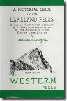
| Gamlin End and High Crag seen from Haystacks summit. |
 |
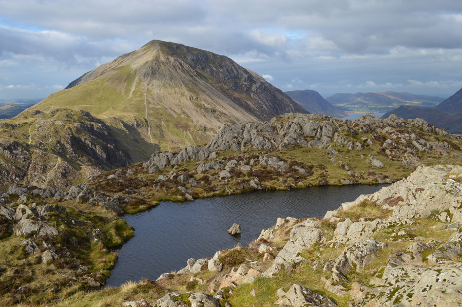
| High Crag seen over Burtness Comb. |
 |
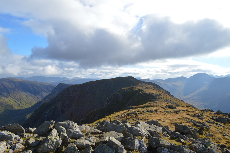
| High Crag over White Cove. |
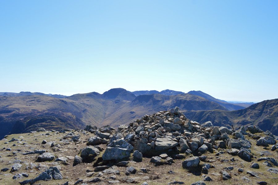 |
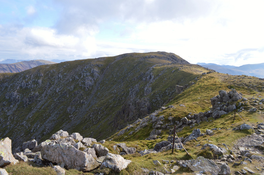
| Brandreth, The Gables, The Scafells and Kirk Fell from High Crag summit. |
|
| |
|
There are 13 walks to choose from including High Crag |
|
|
The High Stile Ridge from Buttermere |
|
|
 |
|
6th August 2025 |
| ASCENT: |
3,011 Feet - 1,403 Metres |
| MILES: |
8.6 |
| WAINWRIGHTS: |
3, Red Pike (Buttermere) - High Stile - High Crag |
| ROUTE: |
Bottom of Newlands Pass - Buttermere Dubs - Old Burtness - Bleaberry Tarn - The Saddle - Red Pike (Buttermere) - High Stile - High Crag - Gamlin End - Seat - Top of Scarth Gap Pass - Scarth Gap Pass - Peggy's Bridge - Gatescarth Farm - East Side Buttermere Lake Path - Wilkinsyke Farm - Bottom of Newlands Pass |
|
| |
|
The Buttermere Horseshoe |
|
|
|
|
5th May 2021 |
| ASCENT: |
6,047 Feet - 1,844 Metres |
| MILES: |
14 |
| WAINWRIGHTS: |
8, Red Pike (Buttermere) - High Stile - High Crag - Hay Stacks - Fleetwith Pike - Dale Head - Hindscarth - Robinson |
| ROUTE: |
Newlands Pass - Buttermere - Old Burtness - Bleaberry Tarn - The Saddle - Red Pike (Buttermere) Top of Chapel Crags - High Stile - High Crag - Gamlin End - Seat - Top of Scarth Gap Pass - Hay Stacks - Innominate Tarn - Black Beck Tarn - Dubs Hut - Fleetwith Pike - Black Star - Honister Mine - Yewcrag Quarries - Dale Head - Hindscarth Edge - Hindscarth - Littledale Edge - Robinson - Buttermere Moss on High Snockrigg - Newlands Pass |
|
| |
|
The Ennerdale Horseshoe |
|
|
|
|
3rd June 2019 |
| ASCENT: |
7,700 Feet - 2,348 Metres |
| MILES: |
24 |
| WAINWRIGHTS: |
14, Great Borne - Starling Dodd - Red Pike (Buttermere) - High Stile - High Crag - Haystacks - Brandreth - Green Gable - Kirk Fell - Pillar - Scoat Fell - Haycock - Caw Fell - Crag Fell |
| ROUTE: |
Bleach Green - Ennerdale Water - Bowness - Herdus - Great Borne - Starling Dodd - Red Pike (Buttermere) - High Stile - High Crag - Gamlin End - Seat - Top of Scarth Gap - Haystacks - Innominate Tarn - Moses trod - Brandreth - Gillercomb Head - Green Gable - Windy Gap - Beck Head - Kirk Fell North Top - Kirk Fell - Baysour Slack - Top of Black Sail Pass - Looking Stead - Pillar - Wind Gap - Black Crag - Scoat Fell - Haycock - Caw Fell - Iron Crag - Crag Fell - Ben Gill - Crag Fell Farm - Bleach Green |
|
| |
|
Walking the Birketts, High Stile And The Buttermere Edge |
|
|
|
|
23rd February 2019 |
| ASCENT: |
2,929 Feet - 893 Metres |
| MILES: |
7 |
| BIRKETTS: |
5, Seat - High Crag - High Stile - Red Pike - Dodd |
| ROUTE: |
Gatescarth - Peggy's Bridge - Scarth Gap Pass - Seat - Gamlin End - High Crag - High Stile - Red Pike - Dodd - Bleaberry Tarn - Sourmilk Gill - Above Burtness Wood - Horse Close - Buttermere Shore Path - Peggy's Bridge - Gatescarth |
|
| |
|
Red Pike to Haystacks from Buttermere |
|
|
|
|
23rd February 2018 |
| ASCENT: |
3,847 Feet - 1,173 Metres |
| MILES: |
9.7 |
| WAINWRIGHTS: |
4, Red Pike (Buttermere) - High Stile - High Crag - Haystacks |
| ROUTE: |
Buttermere – Old Burtness – Bleaberry Tarn – Red Pike (Buttermere) – High Stile – High Crag – Gamlin End – Seat – Top of Scarth Gap – Haystacks – Blackbeck Tarn – Warnscale Beck – Warnscale Bothy - Warnscale Bottom – Gatesgarth – Buttermere |
|
| |
|
Walking the Wainwrights in 30 Walks - Walk 15 Fleetwith Pike to Great Borne |
|
|
|
|
28th May 2016 |
| ASCENT: |
4,500 Feet - 1,373 Meters |
| MILES: |
13.5 |
| WAINWRIGHTS: |
7, Fleetwith Pike - Hay Stacks - High Crag - High Stile - Red Pike (Buttermere) - Starling Dodd - Great Borne
|
| ROUTE: |
Top of Honister Pass - Honister Mines - Fleetwith Pike - Dubs Bottom - Blackbeck Tarn - Innominate Tarn - Hay Stacks - Top of Scarth Gap Pass - Seat - Gamlin End - High Crag - High Stile - Red Pike (Buttermere) - Little Dodd - Starling Dodd - Great Borne - Top of Red Gill - Whiteoak Moss - Scales Force - Buttermere Dubbs - The Fish Inn, Buttermere
|
|
| |
|
Red Pike to Fleethwith Pike from Buttermere |
|
|
|
|
17th October 2015 |
| ASCENT: |
4,010 Feet - 1,403 Metres |
| MILES: |
10.4 |
| WAINWRIGHTS: |
5, Red Pike (Buttermere) - High Stile - High Crag - Hay Stacks - Fleetwith Pike |
| ROUTE: |
Buttermere - Buttermere Dubs - Old Burtness - Bleaberry Tarn - The Saddle - Red Pike (Buttermere) - High Stile - High Crag - Gamlin End - Seat - Top of Scarth Gap Pass - Hay Stacks - Innominate Tarn - Black Beck Tarn - Warnscale Beck - Dubs Hut - Fleetwith Pike - Fleetwith Edge - Gatesgarth Farm - Road back to Buttermere |
|
| |
|
The Harry Griffin 2,000 footers Walk 7 -The Buttermere Skyline |
|
|
|
|
18th April 2015 |
| ASCENT: |
4,000 Feet - 1,219 Metres |
| MILES: |
14.5 |
| SUMMITS OVER 2,000 Ft: |
Honister Crag - Fleetwith Pike - Fleetwith Pike South West Top - High Crag - High Stile - Chapel Crags - Red Pike (Buttermere) - Dodd - Starling Dodd - Great Borne - Great Borne North Top |
| ROUTE: |
Top of Honister Pass - Bell Crags - Honister Crag - Fleetwith Pike South West Top - Fleetwuth Pike - Dubs Bottom - Blackbeck Tarn - Innominate Tarn - Hay Stacks - Top of Scarth Gap Pass - Seat - Gamlin End - High Crag - High Stile - Chapel Crags - Red Pike (Buttermere) - Dodd - Little Dodd - Starling Dodd - Great Borne - Great Borne North Top - Floutern Tarn - Whiteoak Moss - Scales Force - Buttermere Dubbs - The Fish Hotel, Buttermere |
|
| |
|
High Crag via Sheepbone Rake |
|
|
|
|
18th April 2014 |
| ASCENT: |
2,677 feet 816 Meters |
| MILES: |
7.5 |
| WAINWRIGHTS: |
3, High Crag – High Stile – Red Pike (Buttermere) |
| ROUTE: |
Buttermere – Buttermere Lake Path – Burtness Wood – Above Burtness – Burtness Comb – Sheepbone Rake – Burtness Buttress – High Crag – High Stile – Red Pike (Buttermere) – Lingcomb Edge – Scale Beck – Scale Force – Scale Bridge – Buttermere |
|
| |
|
Red Pike to Fleetwith Pike |
|
|
|
|
17th February 2013 |
| ASCENT: |
4,750 Feet, 1,448 Metres |
| MILES: |
9.2 |
| WAINWRIGHTS: |
5, Red Pike (Buttermere) – High Stile – High Crag – Haystacks – Fleetwith Pike |
| ROUTE: |
Buttermere – Old Burtness – Bleaberry Tarn – Red Pike – High Stile – High Crag – Gamlin End – Seat – Scarth Gap – Haystacks – Blackbeck Tarn – Warnscale Beck – Dubs Hut – Dubs Bottom – Fleetwith Pike – Fleetwith Edge – Buttermere Lake Path – Buttermere |
|
| |
|
Red Pike to Haystacks |
|
|
|
|
19th February 2012 |
| ASCENT: |
4,000 Feet, 1,220 Metres |
| MILES: |
10.5 |
| WAINWRIGHTS: |
4, Red Pike, High Stile, High Crag & Haystacks |
| ROUTE: |
Buttermere – Old Burtness – Bleaberry Tarn – Red Pike – High Stile – High Crag – Gamlin End – Seat – Scarth Gap – Haystacks – Blackbeck Tarn – Warnscale Beck – Warnscale bottom – Gatesgarth – Buttermere |
|
| |
|
The High Stile Ridge |
|
|
|
|
30th January 2011 |
| ASCENT: |
2,950 Feet, 899.1 Meters |
| MILES: |
11.9 |
| WAINWRIGHTS: |
5, High Crag, High Stile, Red Pike, Starling Dodd & Great Borne |
| ROUTE: |
|
|
| |
| Back to top |
 |
|