|
Parking Information for - Car Park, Whinlatter Pass, just above Braithwaite |
 |
 |
Parking Details and Map |
 |
|
| Nearest Post Code: |
CA12 5TL |
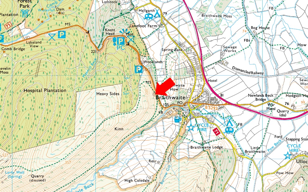
| Grid Reference: |
NY 227 223 |
| Notes: |
Follow the B5292 through Braithwaite Village before joining the bottom of the Whinlatter Pass, here the road steepens after a tight right hand bend, look out for a Parking sign partially hidden by trees on the left hand side an turn left onto the car park. This car park just above Braithwaite is quite small and is very popular especially during the Summer months. The car park provides instant access to Grisedale Pike via Kinn and Force Crag mine. Parking is free. |
|
| |
|
Walks starting from this parking place |
|
|
|
The Coledale Horseshoe |
|
|
 |
|
11th August 2022 |
| ASCENT: |
4,538 Feet - 1,384 Metres |
| MILES: |
11 |
| WAINWRIGHTS: |
9, Grisedale Pike - Hopegill Head - Wandope - Eel Crag (Crag Hill) - Sail - Scar Crags - Causey Pike - Outerside - Barrow |
| ROUTE: |
Whinlatter Pass - Kinn - Sleet How - Grisedale Pike - Hobcarton Head - Hopegill Head - Sand Hill - Coledale Hause - Wandope Moss - Wandope - Eel Crag (Crag Hill) - The Scar - Sail - Scar Crags - Causey Pike - High Moss - Outerside - Barrow Door - Barrow - Braithwaite Lodge - Braithwaite - Whinlatter Pass |
|
| |
|
Grisedale Pike via Coledale |
|
|
|
|
29th August 2021 |
| ASCENT: |
2,403 Feet - 733 Meters |
| MILES: |
6.5 |
| WAINWRIGHTS: |
Grisedale Pike |
| ROUTE: |
Whinlatter Pass - Coledale - Force Crag Mine - Coledale Hause - Hobcarton Head - Grisedale Pike - Sleet How - Kin - Whinlatter Pass |
|
| |
|
Walking the Birketts, Grisedale Pike by the East Ridge |
|
|
|
|
28th April 2019 |
| ASCENT: |
2,434 Feet - 742 Metres |
| MILES: |
6.8 |
| BIRKETTS: |
3, Kin - Grisedale Pike - Hobcarton Head |
| ROUTE: |
Whinlatter – Kinn – Sleet How – Grisedale Pike – Hobcarton Head – Coledale Hause – Force Crag Mine – Coledale Valley – Whinlatter |
|
| |
|
A Coledale Skyline |
|
|
|
|
20th November 2016 |
| ASCENT: |
2,600 Feet - 793 Meters |
| MILES: |
7.5 |
| WAINWRIGHTS: |
2, Grisedale Pike - Hopegill Head |
| ROUTE: |
Whinlatter Pass - Kin - Sleet How - Grisdedale Pike - Hobcarton Crag - Hopegill Head - Sand Hill - Coledale Hause - Force Crag Mine - Mine Track Back To Whinlatter Pass |
|
| |
|
The Harry Griffin 2,000 footers Walk 23 -Around Coledale Hause |
|
|
|
|
15th August 2015 |
| ASCENT: |
5,493 Feet - 1,675 |
| MILES: |
15 |
| SUMMITS OVER 2'000Ft: |
13, Grisedale Pike - Grisedale Pike (NY 139 221) - Hopegill Head - Ladyside Pike - Whiteside - Sand Hill - Grasmoor - Whiteless Pike - Wandope - Eel Crag (Crag Hill) - Sail - Scar Crags - Causey Pike |
| ROUTE: |
Whinlatter Pass – Kin – Sleet How – Grisedale Pike – Hobcarton Crag – Hopegill Head - Ladyside Pike - Whiteside - Traverse below Hopegill Head – Sand Hill – Grasmoor North East Ridge - Grasmoor - Thirdgill Head Man - Whiteless Edge - Whiteless Pike - Whiteless Edge - Wandope – Eel Crag (Crag Hill) – Sail – Scar Crags – Causey Pike – High Moss – Barrow Door – High Coledale – Braithwaite – Whinlatter Pass |
|
| |
|
A Coledale Round |
|
|
|
|
8th June 2014 |
| ASCENT: |
4,200 Feet – 1,280 Meters |
| MILES: |
10.1 |
| WAINWRIGHTS: |
7, Grisedale Pike – Hopegill Head – Wandope – Eel Crag (Crag Hill) – Sail – Sail Pass – Scar Crags – Causey Pike |
| ROUTE: |
Whinlatter Pass – Kin – Sleet How – Grisedale Pike – Hobcarton Crag – Hopegill Head – Sand Hill – Wandope – Eel Crag (Crag Hill) – Sail – Scar Crags – Causey Pike – High Moss – Barrow Door – High Coledale – Braithwaite – Whinlatter Pass |
|
| |
|
Grisedale Pike & Eel Crag via the north ridge |
|
|
|
|
24th November 2013 |
| ASCENT: |
3,622 Feet, 1,104 Meters |
| MILES: |
8.1 |
| WAINWRIGHTS: |
4, Grisedale Pike – Crag Hill (Eel Crag) – Sail – Barrow |
| ROUTE: |
Whinlatter Pass – Kinn – Sleet How – Grisedale Pike – Coledale Hause – Eel Crag North Ridge – Crag Hill (Eel Crag) – The Scar – Sail – Sail Pass – High Moss – Barrow Door – Barrow – Braithwaite Lodge – Braithwaite – Whinlatter Pass |
|
| |
|
Grisedale Pike, Whiteside & Force Crag Mine |
|
|
|
|
18th November 2012 |
| ASCENT: |
736 Metres 2,414 Feet |
| MILES: |
8.1 |
| WAINWRIGHTS: |
3, Grisedale Pike – Hopegill Head – Whiteside |
| ROUTE: |
Whinlatter – Kinn – Sleet How – Grisedale Pike – Hobcarton Crag – Hopegill Head – Whiteside – Hopegill Head – Sand Hill – Coledale Hause – Force Crag Mine – Coledale Valley – Whinlatter |
|
| |
|
The Coledale Horseshoe |
|
|
|
|
6th November 2011 |
| ASCENT: |
4,200 Feet, 1,280 Meters |
| MILES: |
11.5 |
| WAINWRIGHTS: |
8, Grisedale Pike, Hopegill Head, Grasmore, Wandope, Eel Crag (Crag Hill) Sail, Scar Crags, Causey Pike |
| ROUTE: |
Braithwaite, Kin, Sleet How, Grisedale Pike, Hopegill Head, Coledale Hause, Grasmore, Wandope, Eel Cragl (Crag Hill), Sail, Scar Crags, Causey Pike, Rowling End, Uzzicar, Braithwaite |
|
| |
|
The Coledale Horseshoe |
|
|
|
|
17th July 2010 |
| ASCENT: |
1,449 Mtrs 4,100 Ft |
| MILES: |
10.25 |
| WAINWRIGHTS: |
7 Grisdale Pike, Hopegill Head, Crag Hill (Eel Crag) Sail, Scar Crags, Outerside, Barrow |
| ROUTE: |
|
|
| |
|
| |
| Back to top |
 |
|