|
Parking Information for - Mungrisdale Village |
 |
 |
Parking Details and Map |
 |
|
| Nearest Post Code: |
CA11 0XR |
| Grid Reference: |
NY 364 730 |
| Notes: |
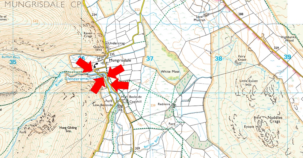
The village of Mungrisdale is quite a small village with limited parking. The lower right arrow points towards a grass verge on the left prior to entering the village with room for around five cars, parking here is free. The lower left arrow points towards the Mill Inn which has a car park to the rear and is for guest only. The upper right arrow is the main car park in the village which is found opposite the village hall where a sign advises users to use the honesty box outside the village hall. The upper left arrow points towards street parking found at the northern edge of the village, to locate, turn left once the red phone box is reached. |
|
| |
|
Walks starting from this parking place |
|
|
|
Blencathra from Mungrisdale |
|
|
 |
|
8th August 2025 |
| ASCENT: |
2,850 Feet - 869 Metres
|
| MILES: |
8 |
| WAINWRIGHTS: |
Bannerdale Crags - Blencathra - Souther Fell
|
| ROUTE: |
Mungrisdale - River Glenderamackin - Bannerdale Crags East Ridge - Bannerdale Crags - Atkinson Pike - Blencathra - Scales Fell - Top of Mousethwaite Comb - Souther Fell - Low Beckside - Mungrisdale
|
|
| |
|
Blencathra & Neighbours |
|
|
|
|
22nd June 2024 |
| ASCENT: |
2,818 Feet - 858 Metres |
| MILES: |
9.8 |
| WAINWRIGHTS: |
4, Bowscale Fell - Mungrisdale Common - Blencathra - Souther Fell |
| ROUTE: |
Mungrisdale - Bannerdale - Bowscale Fell - Glenderamackin Col - Mungrisdale Common - Atkinson Pike - Blencathra - Scales Fell - Top of Mousthwaite Comb - Souther Fell - Low Beckside - Mungrisdale |
|
| |
|
Blencathra from Mungrisdale |
|
|
|
|
9th July 2023 |
| ASCENT: |
2,904 Feet - 885 Metres |
| MILES: |
8.7 |
| WAINWRIGHTS: |
4. Bowscale Fell - Bannerdale Crags - Blencathra - Souther Fell |
| ROUTE: |
Mungrisdale - River Glenderamackin - Bannerdale - Bowscale Fell - Bannerdale Crags - Atkinson Pike - Blencathra - Doddick Fell Top - Scales Fell - Top of Mousthwaite Comb - Souther Fell - Low Beckside - Mungrisdale |
|
| |
|
Bannerdale Crags East Ridge from Mungrisdale |
|
|
|
|
10th September 2022 |
| ASCENT: |
1,900 Feet - 579 Metres |
| MILES: |
6 |
| WAINWRIGHTS: |
2, Bannerdale Crags - Bowscale Fell |
| ROUTE: |
Mungrisdale - River Glenderamackin - Bannerdale Crags East Ridge - Bannerdale Crags - Bowscale Fell - Bowscale Fell East Top - Raven Crags - Mungrisdale |
|
| |
|
Blencathra from Mungrisdale |
|
|
|
|
1st January 2020 |
| ASCENT: |
2,850 Feet - 869 Metres
|
| MILES: |
8 |
| WAINWRIGHTS: |
Bannerdale Crags - Blencathra - Souther Fell
|
| ROUTE: |
Mungrisdale - River Glenderamackin - Bannerdale Crags East Ridge - Bannerdale Crags - Atkinson Pike - Blencathra - Scales Fell - Top of Mousethwaite Comb - Souther Fell - Low Beckside - Mungrisdale
|
|
| |
|
Walking the Birketts, Bannerdale Horseshoe |
|
|
|
|
18th August 2018 |
| ASCENT: |
2,201 Feet - 671 Metres |
| MILES: |
7 |
| BIRKETTS: |
4, Bowscale Fell East Top - Bowscale Fell - Bannerdale Crags - Souther Fell |
| ROUTE: |
Mungrisdale - Bowscale Fell East Top - Bowscale Fell - Top of Bannerdale Crags - Bannerdale Crags - White Horse Bent - River Glenderamackin - Mousthwaite Comb - Souther Fell South Top - Souther Fell Mungrisdale |
|
| |
|
Walking the Wainwrights in 30 Walks Walk 27 - The Back O'Blencathra |
|
|
|
|
16th August 2016 |
| ASCENT: |
4,805 Feet - 1,465 Meters
|
| MILES: |
16.5 |
| WAINWRIGHTS: |
7, Carrock Fell - High Pike (Caldbeck) - Bowscale Fell - Bannerdale Crags - Mungrisdale Common - Blencathra - Souther Fell |
| ROUTE: |
Mungrisdale - Mosedale - Further Gill Syke - Carrock Fell - Miton Hill - High Pike (Caldbeck) - Cumbrian Way - Grainsgill Beck - River Caldew - Bowscale Fell north ridge - Bowscale Fell - Bannerdale Crags - Glederamackin Col - Mungrisdale Common - Blencathra - Scales Fell - Top of Mousthwaite Comb - Souther Fell - Mosedale |
|
| |
|
Souther Fell, Blencathra and the Hall's Fell Ridge |
|
|
|
|
19th March 2016 |
| ASCENT: |
2,866 Feet - 874 Meters |
| MILES: |
7 |
| WAINWRIGHTS: |
2, Souther Fell - Blencathra |
| ROUTE: |
Mungrisdale - Low Beckside - Souther Fell - Top of Mousthwaite Comb - Scales Beck - Scale Tarn - Sharp Edge - Scales Tarn - Scales Tarn Path - Blencathra - Hall's Fell Top - Hall's Fell Ridge - Gate Gill - Gategill Farm - Threlkeld |
|
| |
|
Bowscale Fell to Souther Fell from Mungrisdale |
|
|
|
|
4th October 2014 |
| ASCENT: |
2,200 Feet – 671 Meters |
| MILES: |
7.3 |
| WAINWRIGHTS: |
3, Bowscale Fell – Bannerdale Crags – Souther Fell |
| ROUTE: |
Mungrisdale – Bowscale Fell East Ridge – Bowscale Fell – Bannerdale Crags – White Horse Bent – River Glenderamackin – Top of Mousthwaite Comb – Souther Fell – Mungrisdale |
|
| |
|
The Mungrisdale Fells |
|
|
|
|
19th October 2013 |
| ASCENT: |
1,942 Feet, 592 Meters |
| MILES: |
9.3 |
| WAINWRIGHTS: |
3, Souther Fell – Bannerdale Crags – Bowscale Fell |
| ROUTE: |
Mungrisdale – Low Beckside – Souther Fell – Mousthwaite Comb – River Glenderamackin – White Horse Bent – Bannerdale Crags – Bowscale Fell – Tarn Crags – Bowscale Tarn – Bowscale (Hamlet) – Mungrisdale |
|
| |
|
Souther Fell & the Bannerdale East Ridge |
|
|
|
|
8th September 2012 |
| ASCENT: |
2,360Ft, 719 Metres |
| MILES: |
8.4 |
| WAINWRIGHTS: |
3, Souther Fell, Bannerdale Crags & Bowscale Fell |
| ROUTE: |
Inn – Souther Fell – River Glenderamackin – Bannerdale Crags East Ridge – Bannerdale Crags – Bowscale Fell – Tarn Crags – Bowscale Tarn – Bowscale Township – Mungrisdale Village – Mill Inn |
|
| |
|
The Bannerdale Round |
|
|
|
|
31st October 2010 |
| ASCENT: |
2,560Ft, 780 Mtrs |
| MILES: |
8.7 |
| WAINWRIGHTS: |
3 Souther Fell, Bannerdale Crags & Bowscale Fell |
| ROUTE: |
|
|
| |
|
| |
| Back to top |
 |
|