 |
The Knott |
 |
 |
Map and Photo Gallery |
 |
|
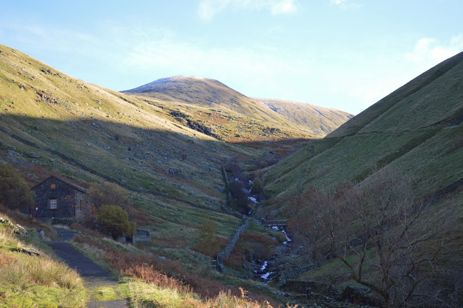 |
| The Knott from Hayeswater Gill. |
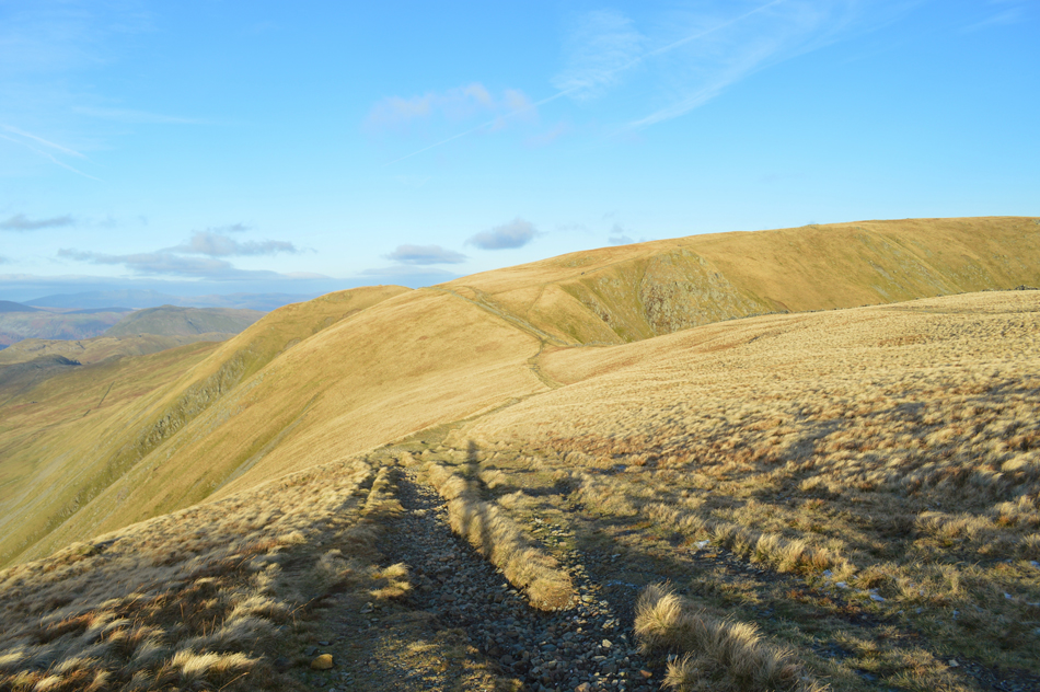 |
| The Knott seen over The Straights of Riggindale. |
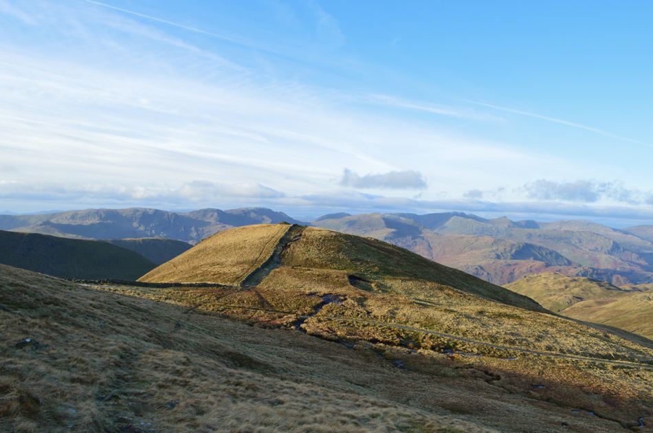 |
| The Knott seen from the descent of Rampsgill Head. |
 |
| Rampsgill Head from the Knott summit. |
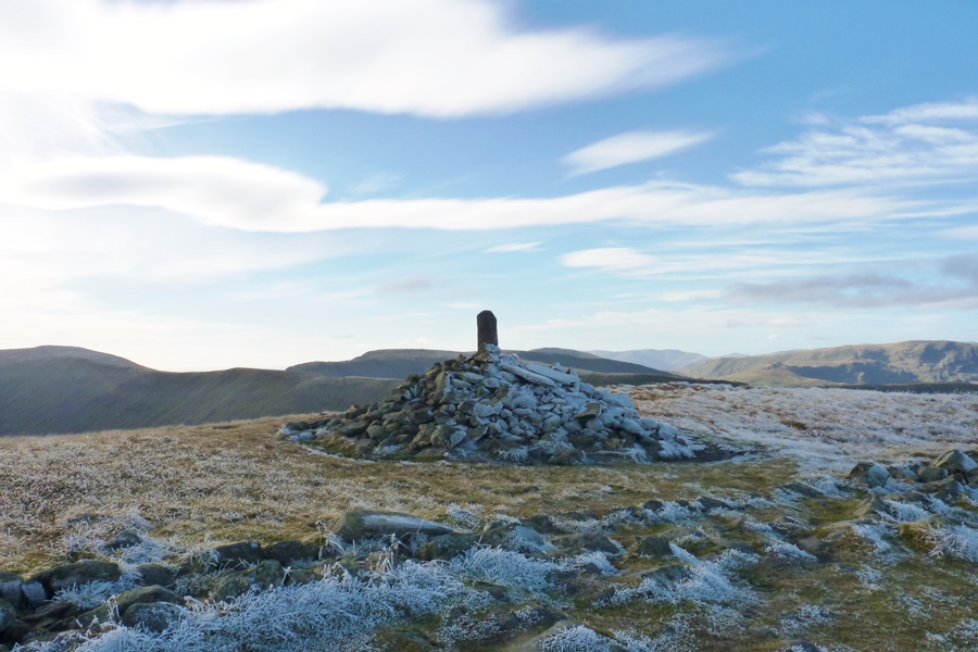 |
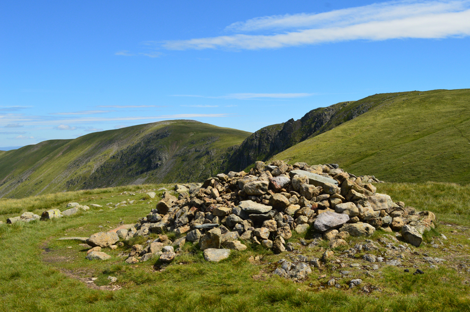
| The Knott summit cairn. |
|
| |
|
There are 34 walks to choose from including The Knott |
|
|
A Riggindale Round |
|
|
 |
|
1st May 2026 |
| ASCENT: |
2,843 Feet - 867 Metres |
| MILES: |
8.1 |
| WAINWRIGHTS: |
5, High Street - The Knott - Rampsgill Head - High Raise - Kidsty Pike |
| ROUTE: |
Mardale Head - Rough Crag - Caspel Gate Tarn - Long Stile - High Street - Straights of Riggindale - The Knott - Rampsgill Head - High Raise - Kidsty Pike - Kidsty Howes - Riggindale Beck - The Rigg - Mardale Head |
|
| |
|
Extended Riggindale Round |
|
|
|
|
25th August 2025 |
| ASCENT: |
3,165 Feet - 964 Metres |
| MILES: |
10.5 |
| WAINWRIGHTS: |
7, High Street - Mardale III Bell - Thornthwaite Crag - The Knott - Rampsgill Head - High Raise (Martindale) - Kidsty Pike |
| ROUTE: |
Mardale Head - The Rigg - Rough Crag - Caspel Gate - Long Stile - High Street - Mardale III Bell - Top of Hall Cove - Thornthwaite Crag - High Street - Straights of Riggindale - The Knott - Rampsgill Head - High Raise (Martindale) - Kidsty Pike - Kidsty Howes - Bowderthwaite Bridge - The Rigg - Mardale Head |
|
| |
|
Mardale Head to Cawdale |
|
|
|
|
21st June 2025 |
| ASCENT: |
2,708 Feet - 825 Metres |
| MILES: |
11 |
| WAINWRIGHTS: |
6, High Street - The Knott - Rampsgill Head - Kidsty Pike - High Raise (Martindale) - Wether Hill |
| ROUTE: |
Mardale Head - The Rigg - Rough Crag - Caspel Gate - Long Stile - High Street - Straights of Riggindale - The Knott - Rampsgill Head - High Raise (Martindale) Raven Howe - Red Crag - Wether Hill - High Kop - Low Kop - The Hause - Hause End - Cawdale |
|
| |
|
An Alternative Hayeswater Circuit |
|
|
|
|
14th December 2024 |
| ASCENT: |
2,727 Feet - 831 Metres |
| MILES: |
8.5 |
| WAINWRIGHTS: |
5, The Knott - Rampsgill Head - High Street - Mardale III Bell - Thornthwaite Crag |
| ROUTE: |
Hartsop - Hayeswater Gill - Hayeswater - The Knott - Rampsgill Head - Two Penny Crag - High Street - Mardale III Bell - Thornthwaite Crag - Hayeswater Gill - Hayeswater - Hayeswater Gill - Hartsop |
|
| |
|
Kirkstone Pass to Hartsop via High Street |
|
|
|
|
2nd November 2024 |
| ASCENT: |
2,238 Feet - 682 Metres |
| MILES: |
7.7 |
| WAINWRIGHTS: |
4, Caudale Moor - Thornthwaite Crag - High Street - The Knott |
| ROUTE: |
Top of Kirkstone Pass - St Raven's Edge - Caudale Moor - Stony Cove Pike - Thresthwaite Mouth - Thornthwaite Crag - High Street - Straights of Riggindale - The Knott - Hayeswater Gill - Hartsop - Cow Bridge |
|
| |
|
Hayeswater Circuit |
|
|
|
|
26th October 2024 |
| ASCENT: |
2,738 Feet - 835 Metres |
| MILES: |
8 |
| WAINWRIGHTS: |
6, The Knott, Rampsgill Head - Kidsty Pike - High Street - Thornthwaite Crag - Gray Crag |
| ROUTE: |
Hartsop - Hayeswater Gill - Hayeswater - The Knott - Rampsgill Head - Kidsty Pike - Straights of Riggindale - High Street - Thornthwaite Crag - Gray Crag - Hayeswater Gill - Hartsop |
|
| |
|
A Riggindale Round |
|
|
|
|
16th September 2024 |
| ASCENT: |
2,539 Feet - 775 Metres |
| MILES: |
7.3 |
| WAINWRIGHTS: |
4, High Street - The Knott - Rampsgill Head - Kidsty Pike |
| ROUTE: |
Mardale Head - Rough Crag - Caspel Gate Tarn - Long Stile - High Street - Straights of Riggindale - The Knott - Rampsgill Head - Kidsty Pike - Kidsty Howes - Riggindale Beck - The Rigg - Mardale Head |
|
| |
|
A Riggindale Round |
|
|
|
|
19th May 2024 |
| ASCENT: |
2,539 Feet - 775 Metres |
| MILES: |
7.3 |
| WAINWRIGHTS: |
4, High Street - The Knott - Rampsgill Head - Kidsty Pike |
| ROUTE: |
Mardale Head - Rough Crag - Caspel Gate Tarn - Long Stile - High Street - Straights of Riggindale - The Knott - Rampsgill Head - Kidsty Pike - Kidsty Howes - Riggindale Beck - The Rigg - Mardale Head |
|
| |
|
Extended Hayeswater Circuit |
|
|
|
|
15th October 2023 |
| ASCENT: |
3,140 Feet - 957 Metres |
| MILES: |
10.5 |
| WAINWRIGHTS: |
8, The Knott - Rampsgill Head - High Raise (Martindale) - Kidsty Pike - High Street - Mardale III Bell - Thornthwaite Crag - Gray Crag |
| ROUTE: |
Hartsop - Hayeswater Gill - Hayeswater - The Knott - Rampsgill Head - High Raise (Martindale) - Kidsty Pike - Straights of Riggindale - High Street - Mardale III Bell - Top of Hall Cove - Thornthwaite Crag - Gray Crag - Hayeswater - Hayeswater Gill - Hartsop |
|
| |
|
A Riggindale Round |
|
|
|
|
4th April 2023 |
| ASCENT: |
2,539 Feet - 775 Metres |
| MILES: |
7.3 |
| WAINWRIGHTS: |
4, High Street - The Knott - Rampsgill Head - Kidsty Pike |
| ROUTE: |
Mardale Head - Rough Crag - Caspel Gate Tarn - Long Stile - High Street - Straights of Riggindale - The Knott - Rampsgill Head - Kidsty Pike - Kidsty Howes - Riggindale Beck - The Rigg - Mardale Head |
|
| |
|
A Riggindale Round |
|
|
|
|
5th September 2018 |
| ASCENT: |
2,539 Feet - 775 Metres |
| MILES: |
7.3 |
| WAINWRIGHTS: |
4, High Street - The Knott - Rampsgill Head - Kidsty Pike |
| ROUTE: |
Mardale Head - Rough Crag - Caspel Gate Tarn - Long Stile - High Street - Straights of Riggindale - The Knott - Rampsgill Head - Kidsty Pike - Kidsty Howes - Riggindale Beck - The Rigg - Mardale Head |
|
| |
|
A Riggindale Round |
|
|
|
|
27th August 2022 |
| ASCENT: |
2,680 Feet - 817 Metres |
| MILES: |
7.6 |
| WAINWRIGHTS: |
4, High Street - The Knott - Rampsgill Head - Kidsty Pike |
| ROUTE: |
Mardale Head - Rough Crag - Caspel Gate Tarn - Long Stile - High Street - Straights of Riggindale - The Knott - Rampsgill Head - Kidsty Pike - Riggindale Beck - The Rigg - Mardale Head |
|
| |
|
High Street from Burnbanks |
|
|
|
|
14th May 2022 |
| ASCENT: |
3,461 Feet - 1,055 Metres |
| MILES: |
16 |
| WAINWRIGHTS: |
6, Wether Hill - Rampsgill Head - The Knott - High Street - Kidsty Pike - High Raise |
| ROUTE: |
Burnbanks - Burn Banks - Four Stones Hill - Low Kop - High Kop - Wether Hill - Red Crag - Raven Howe - High Raise (no summit) - Rampsgill Head - The Knott - Straights of Riggindale - High Street - Straights of Riggindale - Kidsty Pike - High Raise - Low Raise - Long Grain - Measand End - Pultsgill Sike - Measand Beck - Haweswater Shore Path - Burnbanks |
|
| |
|
High Street, Thornthwaite Crag & Pasture Bottom from Hartsop |
|
|
|
|
11th April 2021 |
| ASCENT: |
2,619 Feet - 798 Metres |
| MILES: |
8 |
| WAINWRIGHTS: |
4, The Knott - High Street - Mardale III Bell - Thornthwaite Crag - |
| ROUTE: |
Hartsop - Hayeswater Gill - The Knott - Straights of Riggindale - High Street - Mardale III Bell - Top of Hall Cove - Thornthwaite Crag - Thresthwaite Mouth - Pasture Bottom - Pasture Beck - Hartsop |
|
| |
|
Hayeswater Circuit |
|
|
|
|
14th July 2020 |
| ASCENT: |
2,738 Feet - 835 Metres |
| MILES: |
8 |
| WAINWRIGHTS: |
6, The Knott, Rampsgill Head - Kidsty Pike - High Street - Thornthwaite Crag - Gray Crag |
| ROUTE: |
Hartsop - Hayeswater Gill - Hayeswater - The Knott - Rampsgill Head - Kidsty Pike - Straights of Riggindale - High Street - Thornthwaite Crag - Gray Crag - Hayeswater Gill - Hartsop |
|
| |
|
A Riggindale Round |
|
|
|
|
7th February 2020 |
| ASCENT: |
2,843 Feet - 867 Metres |
| MILES: |
8.1 |
| WAINWRIGHTS: |
5, High Street - The Knott - Rampsgill Head - High Raise - Kidsty Pike |
| ROUTE: |
Mardale Head - Rough Crag - Caspel Gate Tarn - Long Stile - High Street - Straights of Riggindale - The Knott - Rampsgill Head - High Raise - Kidsty Pike - Kidsty Howes - Riggindale Beck - The Rigg - Mardale Head |
|
| |
|
A Riggindale Round |
|
|
|
|
4th December 2019 |
| ASCENT: |
2,533 Feet - 772 Metres |
| MILES: |
6.5 |
| WAINWRIGHTS: |
3, High Street - Rampsgill Head - Kidsty Pike |
| ROUTE: |
Mardale Head - Rough Crag - Caspel Gate Tarn - Long Stile - High Street - Straights of Riggindale - Rampsgill Head - Kidsty Pike - Kidsty Howes - Riggindale Beck - The Rigg - Mardale Head |
|
| |
|
A Riggindale Round |
|
|
|
|
29th June 2019 |
| ASCENT: |
2,843 Feet - 867 Metres |
| MILES: |
8.1 |
| WAINWRIGHTS: |
5, High Street - The Knott - Rampsgill Head - High Raise - Kidsty Pike |
| ROUTE: |
Mardale Head - Rough Crag - Caspel Gate Tarn - Long Stile - High Street - Straights of Riggindale - The Knott - Rampsgill Head - High Raise - Kidsty Pike - Kidsty Howes - Riggindale Beck - The Rigg - Mardale Head |
|
| |
|
A Riggindale Round |
|
|
|
|
5th September 2018 |
| ASCENT: |
2,539 Feet - 775 Metres |
| MILES: |
7.3 |
| WAINWRIGHTS: |
4, High Street - The Knott - Rampsgill Head - Kidsty Pike |
| ROUTE: |
Mardale Head - Rough Crag - Caspel Gate Tarn - Long Stile - High Street - Straights of Riggindale - The Knott - Rampsgill Head - Kidsty Pike - Kidsty Howes - Riggindale Beck - The Rigg - Mardale Head |
|
| |
|
A Riggindale Round |
|
|
|
|
25th November 2017 |
| ASCENT: |
2,843 Feet - 867 Metres |
| MILES: |
8.1 |
| WAINWRIGHTS: |
5, High Street - The Knott - Rampsgill Head - High Raise - Kidsty Pike |
| ROUTE: |
Mardale Head - Rough Crag - Caspel Gate Tarn - Long Stile - High Street - Straights of Riggindale - The Knott - Rampsgill Head - High Raise - Kidsty Pike - Kidsty Howes - Riggindale Beck - The Rigg - Mardale Head |
|
| |
|
A Riggindale Round |
|
|
|
|
26th August 2017 |
| ASCENT: |
2,770 Feet - 844 Metres |
| MILES: |
10.6 |
| WAINWRIGHTS: |
5, High Street - The Knott - Rampsgill Head - Kidsty Pike - High Raise (Martindale) |
| ROUTE: |
Mardale Head - The Rigg - Rough Crag - Caspel Gate - Long Stile - High Street - Straights of Riggindale - The Knott - Rampsgill Head - Kidsty Pike - High Raise (Martindale) - Low Raise - Castle Crag (Fort) - Randale Beck - Riggindale Beck - The Rigg - Mardale Head |
|
| |
|
Caudale Moor to Brock Crags via High Street |
|
|
|
|
1st July 2017 |
| ASCENT: |
4,374 Feet - 1,334 Metres |
| MILES: |
14 |
| WAINWRIGHTS: |
10, Caudale Moor (Stoney Cove Pike) - Thornthwaite Crag - High Street - Kidsty Pike - High Raise (Martindale) - Rampsgill Head - The Knott - Rest Dodd - Angletarn Pikes - Brock Crags |
| ROUTE: |
Cow Bridge - Brothers Water - Hartsop Hall - Sykeside - Kirkstone Pass - Caudale Beck - Caudale Quarry - Caudale Moor (Stoney Cove Pike) - Threshthwaite Mouth - Thornthwaite Crag - High Street - Straights of Riggindale - Kidsty Pike - High Raise (Martindale) - Rampsgill Head - The Knott - Rest Dodd - Satura Crag - Angle Tarn - Angletarn Pikes - Cat Crag - Brock Crags - Hartsop - Cow Bridge |
|
| |
|
A Riggindale Round from Mardale Head |
|
|
|
|
27th December 2016 |
| ASCENT: |
2,843 Feet - 867 Metres |
| MILES: |
8.1 |
| WAINWRIGHTS: |
5, High Street - The Knott - Rampsgill Head - High Raise - Kidsty Pike |
| ROUTE: |
Mardale Head - Rough Crag - Caspel Gate Tarn - Long Stile - High Street - Straights of Riggindale - The Knott - Rampsgill Head - High Raise - Kidsty Pike - Kidsty Howes - Riggindale Beck - The Rigg - Mardale Head |
|
| |
|
Walking the Wainwrights in 30 Walks - Walk 20 Fourteen Fells east of Ullswater |
|
|
|
|
3rd July 2016 |
| ASCENT: |
4,790 Feet - 1,460 Meters |
| MILES: |
19.9 |
| WAINWRIGHTS: |
14, Bonscale Fell - Arthurs Pike - Loadpot Hill - Wether Hill - High Raise (Martindale) - Kidsty Pike - Rampsgill Head - High Street - The Knott - Rest Dodd - The Nab - Brock Crags - Angletarn Pikes - Beda Fell |
| ROUTE: |
Martindale New Church - Mellgaurds - Bonscale Pike - Top of Swarth Beck - Arthurs Pike - Loadpot Hill - Wether Hill - Red Crag - High Raise (Martindale) - Rampsgill Head - Kidsty Pike - Straights of Riggindale - High Street - Straights of Riggindale - The Knott - Rest Dodd - The Nab - Satura Crag - Brock Crags - Angletarn Pikes - Heckbeck Head - Beda Knott - Beda Fell - Winter Crag - Martindale Old Church - Martindale New Church |
|
| |
|
The Harry Griffin 2,000 footers Walk 14 -Walking High Street |
|
|
|
|
23rd May 2015 |
| ASCENT: |
3,864 Feet - 1,178 Metres |
| MILES: |
12 |
| SUMMITS OVER 2,000 Ft: |
Loadpot Hill - Wether Hill (NY 456 167) Wether Hill (NY 455 163) - Red Crag - Raven Howe - High Raise - Kidsty Pike - Rampsgill Head - The Knott - Rest Dodd - High Street - Rough Crag |
| ROUTE: |
Martindale New Church - Howtown - Fusedale - Brock Crag - Loadpot Hill - Wether Hill - Red Crag - Raven How - High Raise - Kidsty Pike - Rampsgill Head - The Knott - Straights of Riggindale - High Street - Rough Crag - Mardale Head |
|
| |
|
Angletarn Pikes to Gray Crag from Hartsop |
|
|
|
|
31st January 2015 |
| ASCENT: |
2,800 Feet – 853 Meters |
| MILES: |
10.4 |
| WAINWRIGHTS: |
2,800 Feet – 853 Meters |
| ROUTE: |
Hartsop – Dubhow – Boredale Hause – Angletarn Pikes – Angle Tarn – Satura Crag – The Knott – Straights of Riggingdale – High Street – Thornthwaite Crag – Gray Crag – Hartsop |
|
| |
|
A Riggindale Round |
|
|
|
|
12th October 2014 |
| ASCENT: |
2,960 Feet 902 Meters |
| MILES: |
8.5 |
| WAINWRIGHTS: |
5, High Street – The Knott – Rampsgill Head – Kidsty Pike – High Raise |
| ROUTE: |
Mardale Head – Rough Crag (Riggindale) – Caspel Gate Tarn – Long Stile – High Street – Straights of Riggindale – The Knott – Rampsgill Head – Kidsty Pike – High Raise – Low Raise – Castle Crag (Mardale) – The Rigg – Mardale Head |
|
| |
|
The Hayeswater Fells from Hartsop |
|
|
|
|
10th November 2013 |
| ASCENT: |
2,600ft, 793 Meters |
| MILES: |
7.6 |
| WAINWRIGHTS: |
4, The Knott – High Street – Thornthwaite Crag – Gray Crag |
| ROUTE: |
Hartsop – Hayeswater – The Knott – Straights of Riggindale – High Street – Thornthwaite Crag – Gray Crag – Hayeswater – Filter House – Hartsop |
|
| |
|
The Martindale Horseshoe |
|
|
|
|
19th May 2013 |
| ASCENT: |
4,007 Feet, 1,221 Metres |
| MILES: |
12 |
| WAINWRIGHTS: |
9, Beda Fell – Angletarn Pikes – Brock Crags – Rest Dodd – The Knott – Rampsgill Head – High Raise – Wether Hill – Steel Knotts (Pikeawassa) |
| ROUTE: |
Martindale New Church – Martindale Old Church – Winter Crag – Beda Fell – Bedafell Knott – Angletarn Pikes – Brock Crags – Satura Crag – Rest Dodd – The Knott – Rampsgill Head – High Raise – Raven Howe – Red Crag – High Street Roman Road (Course Of) – Wether Hill – Brownthwaite Crag – Steel Knotts (Pikeawassa) – Birkie Knott – Lanty Tarn – Martindale New Church |
|
| |
|
One year on… |
|
|
|
|
27th October 2012 |
| ASCENT: |
3,713 Feet, 1,132 Metres |
| MILES: |
12.8 |
| WAINWRIGHTS: |
5, Place Fell – Angletarn Pikes – The Knott – High Street – Thornthwaite Crag |
| ROUTE: |
Hartsop – Dubhow – Beckstones – Crookabeck – Rooking – Side Farm – Place Fell – Round How – Steel Edge – Boredale Hause – Angletarn Pikes – Angle Tarn – Satura Crag – The Knott – Straights Of Riggindale – High Street – Thornthwaite Crag – Thresthwaite Mouth – Pasture Bottom – Pasture Beck - Hartsop |
|
| |
|
Deluge On The Far Eastern Fells |
|
|
|
|
16th July 2011 |
| ASCENT: |
3,261 Feet, 992 Meters |
| MILES: |
12.5 |
| WAINWRIGHTS: |
7, Beda Fell, Brock Crags, The Knott, Rampsgill Head, High Raise, Rest Dodd & The Nab |
| ROUTE: |
|
|
| |
|
Dodging The Showers On High Street |
|
|
|
|
7th May 2011 |
| ASCENT: |
3,406 Feet, 1,038 Meters |
| MILES: |
7.7 |
| WAINWRIGHTS: |
4, The Knott, High Street, Caudale Moor & Hartsop Dodd |
| ROUTE: |
|
|
| |
|
Brock Crags, Rest Dodd & The Knott |
|
|
|
|
28th November 2010 |
| ASCENT: |
2,423 Ft 738.5 Mtrs |
| MILES: |
8.7 |
| WAINWRIGHTS: |
3, Brock Crags, Rest Dodd & The Knott |
| ROUTE: |
|
|
| |
|
High Street From Patterdale |
|
|
|
|
8th February 2009 |
| ASCENT: |
828 Mtrs 2718 ft |
| MILES: |
11 |
| WAINWRIGHTS: |
3 Angletarn Pikes, The Knott, High Street |
| ROUTE: |
Patterdale - Rooking - Boredale Hause - Angletarn Pikes - Satura Crag - The Knott - Straights of Riggindale - High Street - Straights of Riggindale - Satura Crag - Boredale Hause - Rooking - Patterdale |
|
| |
|
High Street From Hartsop |
|
|
|
|
11th April 2008 |
| ASCENT: |
2718 Feet - 828 Metres |
| MILES: |
6.4 |
| WAINWRIGHTS: |
2 The Knott, High Street |
| ROUTE: |
Syke Side Camp Site - Hartsop - Hayeswater Gill - Hayeswater - The Knott - Straights of Riggindale - High Street - Straights of Riggindale - The Knott - Hayeswater - Hayeswater - Hartsop - Syke Side Camp Site |
|
| |
| Back to top |
 |
|

