|
Parking Information for - Patterdale Village |
 |
 |
Parking Details and Map |
 |
|
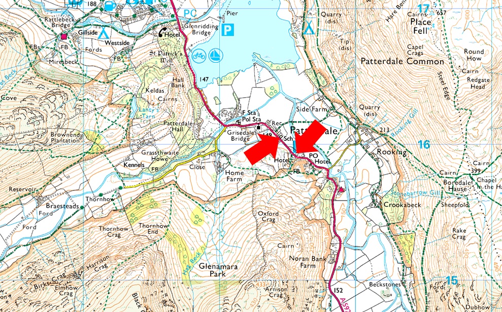
| Nearest Post Code: |
CA11 0NW |
| Grid Reference: |
White Lion Hotel - NY 395 315 - Patterdale Primary School NY 394 516 |
| Notes: |
Patterdale alongside Glenriddging acts as a hub for the eastern and far eastern fells yet unlike Glenridding Patterdale doesn't have a centralised car park. With this said parking in Patterdale, especially during the height of Summer can be a problem with only two main sites to leave your car. The first is very popular with fell walkers which is just opposite the White Lion Hotel, here you will find a short layby with room for up to five parked cars. Parking is free. The second place to park is found just outside Patterdale Primary School were you can park on the kerb right outside the School, here you will find spaces for around three to four well parked cars. Parking is free. |
|
| |
|
Walks starting from this parking place |
|
|
|
Fairfield from Patterdale |
|
|
 |
|
14th February 2026 |
| ASCENT: |
3,256 Feet - 992 Metres |
| MILES: |
9.5 |
| WAINWRIGHTS: |
4, Arnison Crag - Birks - St Sunday Crag - Fairfield |
| ROUTE: |
Patterdale - Arnison Crag - Trough Head - Birks - St Sunday Crag - Deepdale Hause - Cofa Pike - Fairfield - Hause Gap - Grisedale Tarn - Grisedale - Ruthwaite Lodge - Elmhow - Patterdale |
|
| |
|
St Sunday Crag & Fairfield from Patterdale |
|
|
|
|
18th January 2025 |
| ASCENT: |
3,255 Feet - 992 Metres |
| MILES: |
9 |
| WAINWRIGHTS: |
3, Birks - St Sunday Crag - Fairfield |
| ROUTE: |
Patterdale - Grisedale - Thornhow End - Birks - St Sunday Crag - Deepdale Hause - Cofa Pike - Fairfield - Hause Gap - Grisedale Tarn - Grisedale - Ruthwaite Lodge - Elmhow - Patterdale |
|
| |
|
Helvellyn, Dollywaggon Pike & The Grisedale Valley |
|
|
|
|
31st August 2024 |
| ASCENT: |
3,108 Feet - 947 Metres |
| MILES: |
10 |
| WAINWRIGHTS: |
3, Helvellyn - Nethermost Pike - Dollywaggon Pike |
| ROUTE: |
Patterdale - Grisedale Lane - Grisedale Brow - Hole-in-the-Wall - Red Tarn - Swirral Edge - Helvellyn - Nethermost Pike - High Crag - Dollywaggon Pike - The Tongue - Ruthwaite Lodge - Grisedale - Elmhow - Grisedale Lane - Patterdale |
|
| |
|
St Sunday Crag via Grisedale |
|
|
|
|
26th January 2024 |
| ASCENT: |
2,560 Feet 781 Metres |
| MILES: |
8 |
| WAINWRIGHTS: |
2, St Sunday Crag - Birks |
| ROUTE: |
Patterdale - Glenamara Park - Hag Beck - Grisedale - Thornhow - Elmhow - Ruthwaite Lodge - Grisedale Tarn - Deepdale Hause - St Sunday Crag - Birks - Thornhow End - Hag Beck - Glenamara Park - Patterdale |
|
| |
|
Not quite Grisedale Tarn |
|
|
|
|
2nd December 2023 |
| ASCENT: |
885 Feet - 269 Metres |
| MILES: |
6.2 |
| WAINWRIGHTS: |
N/A |
| ROUTE: |
Patterdale - Grisedale Lane - Grisedale - Ruthwaite Lodge - Grisedale - Grisedale Lane - Patterdale |
|
| |
|
Helvellyn by the Edges |
|
|
|
|
9th August 2023 |
| ASCENT: |
2,950 Feet - 899 Metres |
| MILES: |
7 |
| WAINWRIGHTS: |
Helvellyn |
| ROUTE: |
Patterdale - Grisedale Lane - Grisedale Brow - Hole-in-the-Wall - Striding Edge - Helvellyn - Swirral Edge - Red Tarn - Hole-in-the-Wall - Patterdale |
|
| |
|
Place Fell from Patterdale |
|
|
|
|
24th June 2023 |
| ASCENT: |
2,382 Feet - 726 Metres |
| MILES: |
7.6 |
| WAINWRIGHTS: |
Place Fell |
| ROUTE: |
Patterdale - Goldrill Beck - Boredale Hause - Round How - Place Fell - Scalehow Force - Ullswater Shore Path back to Side Farm - Patterdale |
|
| |
|
A low level walk through Patterdale & Dovedale |
|
|
|
|
9th January 2022 |
| ASCENT: |
742 Feet - 226 Metres |
| MILES: |
8.6 |
| WAINWRIGHTS: |
N/A |
| ROUTE: |
Patterdale - Rooking - Crookabeck - Beckstones - Hartsop - Cow Bridge - Brothers Water - Deepdale - Sykeside Campsite - Brothers Water East Shore Path - Hartsop - Cow Bridge - Low Wood - A592 - Deepdale Bridge - Greenbank Farm - Patterdale |
|
| |
|
St Sunday Crag via Grisedale |
|
|
|
|
19th December 2021 |
| ASCENT: |
2,704 Feet - 825 Metres |
| MILES: |
8.4 |
| WAINWRIGHTS: |
3, St Sunday Crag - Birks - Arnison Crag |
| ROUTE: |
Patterdale - Grisedale Lane - Grisedale - Ruthwaite Lodge - Grisedale Tarn - Deepdale Hause - St Sunday Crag - Birks - Trough Head - Arnison Crag - Patterdale |
|
| |
|
Angletarn Pikes & Brock Crags from Patterdale |
|
|
|
|
7th November 2021 |
| ASCENT: |
1,823 Feet - 556 Metres |
| MILES: |
6 |
| WAINWRIGHTS: |
2, Angletarn Pikes - Brock Crags |
| ROUTE: |
Patterdale School - Goldrill Beck - Boredale Hause - Angletarn Pikes - Angletarn Pikes South Summit - Angle Tarn - Brock Crags - Footpath Above Hayeswater Gill - Calf Close - Angletarn Beck - Beckstones - Crookabeck - Rooking - Patterdale |
|
| |
|
St Sunday Crag |
|
|
|
|
14th December 2019 |
| ASCENT: |
2,560 Feet 781 Metres |
| MILES: |
8 |
| WAINWRIGHTS: |
2, St Sunday Crag - Birks |
| ROUTE: |
Patterdale - Grisedale Bridge - Grisedale - Ruthwaite Lodge - Grisedale Tarn - Deepdale Hause - St Sunday Crag - Birks - Grisedale Bridge - Patterdale |
|
| |
|
Walking the Birketts, Deepdale Horseshoe |
|
|
|
|
14th April 2018 |
| ASCENT: |
3,521 Feet - 1,073 Meters |
| MILES: |
9.5 |
| BIRKETTS: |
9, Arnison Crag - Birks - Gavel Pike - St Sunday Crag - Cofa Pike - Fairfield - Hart Crag - Giil Crag (Hartsop above How) - Gale Crag |
| ROUTE: |
Patterdale - Oxford Crag - Arnison Crag - Trough Head - Birks - Gavel Pike - St Sunday Crag - Deepdale Hause - Cofa Pike - Fairfield - Link Hause - Hart Crag - Giil Crag (Hartsop above How) - Gale Crag - Deepdale Bridge - Patterdale |
|
| |
|
Place Fell from Patterdale |
|
|
|
|
28th October 2017 |
| ASCENT: |
2,382 Feet - 726 Metres |
| MILES: |
7.6 |
| WAINWRIGHTS: |
Place Fell |
| ROUTE: |
Patterdale - Side Farm - Boredale Hause - Round How - Place Fell - Scalehow Force - Ullswater Shore Path back to Side Farm - Patterdale |
|
| |
|
The tale of Charles Gough and his faithful dog Foxie |
|
|
|
|
8th July 2017 |
| ASCENT: |
2,950 Feet 899 Metres |
| MILES: |
8.5 |
| WAINWRIGHTS: |
Helvellyn |
| ROUTE: |
Patterdale - Grisedale Lane - Grisedale Brow - Hole-in-the-Wall - Striding Edge - Helvellyn - Swirral Edge - Red Tarn - Hole-in-the-Wall - Patterdale |
|
| |
|
A Deepdale Horseshoe |
|
|
|
|
8th October 2016 |
| ASCENT: |
3,448 Feet - 1,051 Meters |
| MILES: |
10.2 |
| WAINWRIGHTS: |
6, Arnison Crag - Birks - St Sunday Crag - Fairfield - Hart Crag - Hartsop above How |
| ROUTE: |
Patterdale - Arnison Crag - Trough Head - Birks - St Sunday Crag - Deepdale Hause - Cofa Pike - Fairfield - Hart Crag - Hartsop Above How - Deepdale Bridge - A592 – Patterdale |
|
| |
|
The Harry Griffin 2,000 footers Walk 24 -Place Fell |
|
|
|
|
23rd August 2015 |
| ASCENT: |
1,662 Feet - 507 Meters |
| MILES: |
4.5 |
| SUMMITS OVER 2'000Ft: |
2, Place Fell - Round How |
| ROUTE: |
Patterdale - Above Side Farm - Grey Crag - The Knight - Place Fell - Round How - Steel Edge - Boredale Hause - Rooking - Patterdale |
|
| |
|
The Harry Griffin 2,000 footers Walk 18 -Helvellyn Days |
|
|
|
|
27th June 2015 |
| ASCENT: |
6,468 Feet 1,972 Metres |
| MILES: |
16.2 |
| SUMMITS OVER 2,000 Ft: |
15, Birkhouse Moor (NY 365 163) - Birkhouse Moor (NY 363 159) - Birkhouse Moor (NY 361 158) Birkhouse Moor (NY 360 157) - Helvellyn - Catstye Cam - Helvellyn Lower Man - White Side - Raise - Nethermost Pike - High Crag - Dollywaggon Pike - Seat Sandal - St Sunday Crag - Gavel Pike |
| ROUTE: |
Patterdale - Glenridding - Birkhouse Moor North East Ridge - Hole-in-the-Wall - Striding Edge - Helvellyn - Swirral Edge - Catstye Cam - Swirral Edge - Helvellyn Lower Man - White Side - Raise - White Side - Helvellyn Lower Man - Helvellyn - Nethermost Pike - High Crag - Dollywaggon Pike - Seat Sandal - Grisedale Tarn - Deepdale Hause - St Sunday Crag - Gavel Pike - Thornhow End - Grisedale Lane - Patterdale |
|
| |
|
A Grisedale Horseshoe via Striding Edge |
|
|
|
|
13th September 2014 |
| ASCENT: |
4,934 Feet – 1,540 Meters |
| MILES: |
11.8 |
| WAINWRIGHTS: |
8, Helvellyn – Nethermost Pike – Dollywaggon Pike – Seat Sandal – Fairfield – St Sunday Crag – Birks – Arnison Crag |
| ROUTE: |
Patterdale – Grisedale – Striding Edge – Helvellyn – Nethermost Pike – High Crag – Dollywaggon Pike – Grisedale Tarn – Seat Sandal – Grisedale Hause – Fairfield – Cofa Pike – Deepdale Hause – St Sunday Crag – Birks – Trough Head – Arnison Crag – Oxford Crag – Patterdale |
|
| |
|
Angletarn Pikes, Beda Fell & Ullswater |
|
|
|
|
5th April 2014 |
| ASCENT: |
2,300 Feet – 702 Meters |
| MILES: |
10.5 |
| WAINWRIGHTS: |
2 Angletarn Pikes – Beda Fell |
| ROUTE: |
Patterdale School – Rooking – Boredale Hause – Angletarn Pikes – Heck Crag – Bedafell Knott – Beda Fell – Beda Head – Winter Crag – Doe Green – Sandwick – Ullswater shore path – Patterdale School |
|
| |
|
Helvellyn & the Nethermost Pike East Ridge |
|
|
|
|
7th October 2012 |
| ASCENT: |
3,149 Feet, 960 Metres |
| MILES: |
9 |
| WAINWRIGHTS: |
2, Helvellyn & Nethermost Pike |
| ROUTE: |
Patterdale – Hole-in-the-Wall – Striding Edge – Helvellyn – Nethermost Pike – Nethermost Pike East Ridge – Hard Tarn – Eagle Crag – Nethermost Beck – Grisedale Valley – Patterdale |
|
| |
|
The Grisedale Horseshoe |
|
|
|
|
10th March 2012 |
| ASCENT: |
4,590 Feet, 1,400 Metres |
| MILES: |
11.5 |
| WAINWRIGHTS: |
5, Helvellyn, Nethermost Pike, Dollywaggon Pike, Saint Sunday Crag & Birks |
| ROUTE: |
Patterdale – Grisedale Bridge – Brownend Plantation – Hole-in-the-wall – Birkhouse Moor – Red Tarn (Helvellyn) – Swirral Edge – Helvellyn – Nethermost Pike – High Crag – Dollywaggon Pike – Grisedale Tarn – Deepdale Hause – Saint Sunday Crag – Birks – Patterdale |
|
| |
|
My 214th Wainwright |
|
|
|
|
29th October 2011 |
| ASCENT: |
2,300 Feet, 701 Meters |
| MILES: |
6.5 |
| WAINWRIGHTS: |
2, Place Fell & Angletarn Pikes |
| ROUTE: |
Patterdale Place Fell Cottage PlaceFell Boredale Hause Angletarn Pikes Angle Tarn (Patterdale) Boredale Hause Patterdale |
|
| |
|
St Sunday Crag via Arnison Crag |
|
|
|
|
29th August 2011 |
| ASCENT: |
2,760 Feet, 841 Meters |
| MILES: |
9 |
| WAINWRIGHTS: |
3, Arnison Crag, Birks & St Sunday Crag |
| ROUTE: |
|
|
| |
|
A Grisedale Retreat |
|
|
|
|
4th December 2010 |
| ASCENT: |
875 Ft, 267 Mtrs |
| MILES: |
4 |
| WAINWRIGHTS: |
N/A |
| ROUTE: |
|
|
| |
|
Brock Crags, Rest Dodd & The Knott |
|
|
|
|
28th November 2010 |
| ASCENT: |
2,423 Ft 738.5 Mtrs |
| MILES: |
8.7 |
| WAINWRIGHTS: |
3, Brock Crags, Rest Dodd & The Knott |
| ROUTE: |
|
|
| |
|
St Sunday Crag |
|
|
|
|
18th April 2010 |
| ASCENT: |
873 Mtrs 2,863 Ft |
| MILES: |
9.9 |
| WAINWRIGHTS: |
4, Seat Sandal, Fairfield, St Sunday Crag, Birks |
| ROUTE: |
|
|
| |
|
High Street From Patterdale |
|
|
|
|
8th February 2009 |
| ASCENT: |
828 Mtrs 2718 ft |
| MILES: |
11 |
| WAINWRIGHTS: |
3 Angletarn Pikes, The Knott, High Street |
| ROUTE: |
Patterdale - Rooking - Boredale Hause - Angletarn Pikes - Satura Crag - The Knott - Straights of Riggindale - High Street - Straights of Riggindale - Satura Crag - Boredale Hause - Rooking - Patterdale |
|
| |
|
Angle Tarn |
|
|
|
|
17th March 2007 |
| ASCENT: |
485 Mtrs |
| MILES: |
xxx |
| WAINWRIGHTS: |
0 (We didn’t make the summit of Angle Tarn Pike) |
| ROUTE: |
xxxx |
|
| |
|
| |
| Back to top |
 |
|